Trail difficulty
75
HKG
|
| Track : albir_-_sierra_helada_-_benidorm.gpx |
|
These speeds are average for : HKG
(Hiking) Reanalyze as BYC (Bicycle) RNG (Running) |
|
|
| Level of correction applied to the trail: 0 |
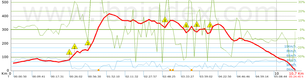
| Total length: 10.75 Km mi / ft ? |
| Analyzed distance: 10.75 Km |
| Lineal distance: 5.51 Km |
| Accumulated climb: 730.1 m |
 info Points list info Points list |
| Accumulated descent: 780.3 m | |
| Maximum height: 418.8 m | |
| Minimal height: 3 m | |
| Start height: 54 m | |
| End height : 3 m | |
| Climb rate: 15.19 % | |
| Descent rate: 14.02 % | |
| Positive climb difference per Km: 67.92 m | |
| Negative descent difference per Km: 72.59 m | |
| Max slope filter: ~55 % |
| Min. points separation: ~30 m |
| Number of points: 756 (cad. 14.22 m) |
| Significant points: 294 (cad. 36.69 m / 38.89 %) |
| Direction changes per Km: 14.23 |
| Direction changes >5ş per Km: 12.19 |
| Accumulated straight stretches: 0.848 Km |
| Straight stretches per Km: 78.88 m |
| Penalizables slope changes: 7 |
| Penalizables slope changes per Km: 0.651 |
| Total time: 5:24:45 h |
| Time in movement: 3:46:14 h |
| Stopped time: 1:38:31 h |
| Total speed average: 1.99 Km/h |
| Average speed in movement : 2.85 Km/h |
| Maximum held speed: 5.93 Km/h |
 |
|
|
Remove track and analysis |
|
|
Save this trail on "My trails" |