Trail difficulty
38
BYC
|
| Track : aragon-zaragoza-sendas-alfocea.gpx |
|
These speeds are average for : BYC
(Bicycle) Reanalyze as HKG (Hiking) RNG (Running) |
| Penalty trail's conditions: 51 % ( > 50 % = MTB, < 50 % = RDB) |
|
|
Level of correction applied to the trail:
5
 See original analysis (without corrections) See original analysis (without corrections)
|
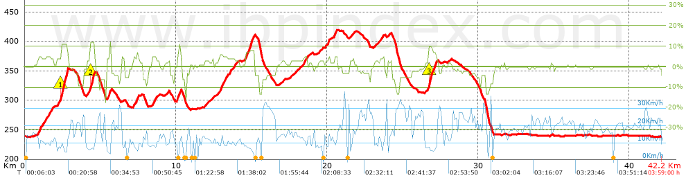
| Total length: 42.17 Km mi / ft ? |
| Analyzed distance: 42.17 Km |
| Lineal distance: 0 Km |
| Accumulated climb: 575.33 m |
info Points list |
| Accumulated descent: 583.19 m | |
| Maximum height: 419.31 m | |
| Minimal height: 237.9 m | |
| Start height: 238.6 m | |
| End height : 238 m | |
| Climb rate: 4.17 % | |
| Descent rate: 4.64 % | |
| Positive climb difference per Km: 13.64 m | |
| Negative descent difference per Km: 13.83 m | |
| Max slope filter: ~30 % |
| Min. points separation: ~30 m |
| Number of points: 2092 (cad. 20.16 m) |
| Significant points: 1045 (cad. 40.39 m / 49.95 %) |
| Direction changes per Km: 11.05 |
| Direction changes >5ş per Km: 8.02 |
| Accumulated straight stretches: 7.344 Km |
| Straight stretches per Km: 174.15 m |
| Penalizables slope changes: 9 |
| Penalizables slope changes per Km: 0.213 |
| Total time: 3:59:00 h |
| Time in movement: 2:57:39 h |
| Stopped time: 1:01:21 h |
| Total speed average: 10.59 Km/h |
| Average speed in movement : 14.24 Km/h |
| Maximum held speed: 43.07 Km/h |
Your fitness level
49
|
 |
|
|
Remove track and analysis |
|
|
Save this trail on "My trails" |