Trail difficulty
58
BYC
|
| Track : aragon-divisoria-sendas-urcamusa.gpx |
|
These speeds are average for : BYC
(Bicycle) Reanalyze as HKG (Hiking) RNG (Running) |
| Penalty trail's conditions: 55 % ( > 50 % = MTB, < 50 % = RDB) |
|
|
Level of correction applied to the trail:
2
 See original analysis (without corrections) See original analysis (without corrections)
|
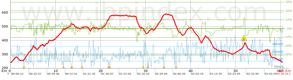
| Total length: 60.54 Km mi / ft ? |
| Analyzed distance: 60.54 Km |
| Lineal distance: 0.01 Km |
| Accumulated climb: 986.7 m |
info Points list |
| Accumulated descent: 976.29 m | |
| Maximum height: 589.68 m | |
| Minimal height: 241.67 m | |
| Start height: 242.5 m | |
| End height : 242.5 m | |
| Climb rate: 3.93 % | |
| Descent rate: 3.88 % | |
| Positive climb difference per Km: 16.3 m | |
| Negative descent difference per Km: 16.13 m | |
| Max slope filter: ~30 % |
| Min. points separation: ~30 m |
| Number of points: 2897 (cad. 20.9 m) |
| Significant points: 1195 (cad. 50.7 m / 41.25 %) |
| Direction changes per Km: 9.13 |
| Direction changes >5ş per Km: 7.12 |
| Accumulated straight stretches: 6.932 Km |
| Straight stretches per Km: 114.5 m |
| Penalizables slope changes: 10 |
| Penalizables slope changes per Km: 0.165 |
| Total time: 3:58:39 h |
| Time in movement: 3:29:54 h |
| Stopped time: 0:28:45 h |
| Total speed average: 15.22 Km/h |
| Average speed in movement : 17.31 Km/h |
| Maximum held speed: 44.33 Km/h |
Your fitness level
30
|
 |
|
|
Remove track and analysis |
|
|
Save this trail on "My trails" |