Trail difficulty
47
BYC
|
| Track : completa-aragon-teruel-via-verde-ojos-negros.gpx |
|
These speeds are average for : BYC
(Bicycle) Reanalyze as HKG (Hiking) RNG (Running) |
| Penalty trail's conditions: 27 % ( > 50 % = MTB, < 50 % = RDB) |
|
|
| Level of correction applied to the trail: 0 |
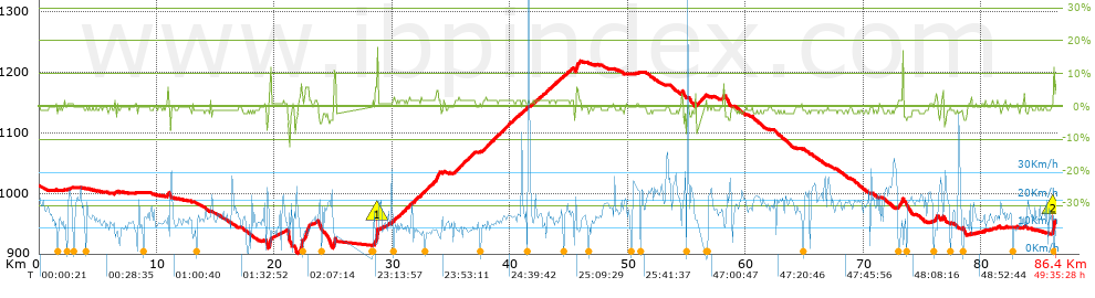
| Total length: 86.36 Km mi / ft ? |
| Analyzed distance: 86.36 Km |
| Lineal distance: 57.92 Km |
| Accumulated climb: 514.1 m |
 info Points list info Points list |
| Accumulated descent: 514.7 m | |
| Maximum height: 1218.9 m | |
| Minimal height: 901.3 m | |
| Start height: 1012.8 m | |
| End height : 953.8 m | |
| Climb rate: 2.39 % | |
| Descent rate: 2.04 % | |
| Positive climb difference per Km: 5.95 m | |
| Negative descent difference per Km: 5.96 m | |
| Max slope filter: ~30 % |
| Min. points separation: ~30 m |
| Number of points: 6213 (cad. 13.9 m) |
| Significant points: 2244 (cad. 38.5 m / 36.12 %) |
| Direction changes per Km: 10.9 |
| Direction changes >5ş per Km: 2.49 |
| Accumulated straight stretches: 40.782 Km |
| Straight stretches per Km: 472.23 m |
| Penalizables slope changes: 3 |
| Penalizables slope changes per Km: 0.035 |
| Total time: 49:35:28 h |
| Time in movement: 5:56:51 h |
| Stopped time: 43:38:37 h |
| Total speed average: 1.74 Km/h |
| Average speed in movement : 14.52 Km/h |
| Maximum held speed: 65.13 Km/h |
Your fitness level
87
|
 |
|
|
Remove track and analysis |
|
|
Save this trail on "My trails" |