Trail difficulty
16
BYC
|
| Track : v_v_ojos_negros_02.gpx |
|
These speeds are average for : BYC
(Bicycle) Reanalyze as HKG (Hiking) RNG (Running) |
| Penalty trail's conditions: 14 % ( > 50 % = MTB, < 50 % = RDB) |
|
|
| Level of correction applied to the trail: 0 |
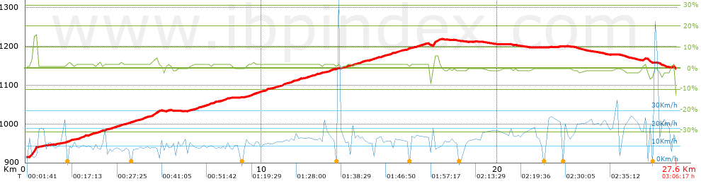
| Total length: 27.56 Km mi / ft ? |
| Analyzed distance: 27.56 Km |
| Lineal distance: 21.16 Km |
| Accumulated climb: 315.9 m |
 info Points list info Points list |
| Accumulated descent: 78.4 m | |
| Maximum height: 1218.9 m | |
| Minimal height: 914.3 m | |
| Start height: 914.3 m | |
| End height : 1142.8 m | |
| Climb rate: 2.03 % | |
| Descent rate: 1.91 % | |
| Positive climb difference per Km: 11.46 m | |
| Negative descent difference per Km: 2.84 m | |
| Max slope filter: ~30 % |
| Min. points separation: ~30 m |
| Number of points: 557 (cad. 49.48 m) |
| Significant points: 410 (cad. 67.39 m / 73.61 %) |
| Direction changes per Km: 4.93 |
| Direction changes >5ş per Km: 2.39 |
| Accumulated straight stretches: 12.896 Km |
| Straight stretches per Km: 467.92 m |
| Penalizables slope changes: 1 |
| Penalizables slope changes per Km: 0.036 |
| Total time: 3:06:17 h |
| Time in movement: 2:03:57 h |
| Stopped time: 1:02:20 h |
| Total speed average: 8.88 Km/h |
| Average speed in movement : 13.34 Km/h |
| Maximum held speed: 63.73 Km/h |
Your fitness level
?*
|
 |
|
|
Remove track and analysis |
|
|
Save this trail on "My trails" |