Trail difficulty
32
BYC
|
| Track : madrid-circular-ajalvir-serracines.gpx |
|
These speeds are average for : BYC
(Bicycle) Reanalyze as HKG (Hiking) RNG (Running) |
| Penalty trail's conditions: 30 % ( > 50 % = MTB, < 50 % = RDB) |
|
|
| Level of correction applied to the trail: 0 |
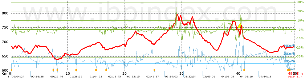
| Total length: 49.9 Km mi / ft ? |
| Analyzed distance: 49.9 Km |
| Lineal distance: 0 Km |
| Accumulated climb: 554 m |
 info Points list info Points list |
| Accumulated descent: 547.8 m | |
| Maximum height: 795 m | |
| Minimal height: 637.7 m | |
| Start height: 685.5 m | |
| End height : 685.6 m | |
| Climb rate: 3.48 % | |
| Descent rate: 3.07 % | |
| Positive climb difference per Km: 11.1 m | |
| Negative descent difference per Km: 10.98 m | |
| Max slope filter: ~30 % |
| Min. points separation: ~30 m |
| Number of points: 1009 (cad. 49.46 m) |
| Significant points: 689 (cad. 72.53 m / 68.29 %) |
| Direction changes per Km: 6.35 |
| Direction changes >5ş per Km: 4.65 |
| Accumulated straight stretches: 14.61 Km |
| Straight stretches per Km: 292.79 m |
| Penalizables slope changes: 4 |
| Penalizables slope changes per Km: 0.08 |
| Total time: 5:24:11 h |
| Time in movement: 3:41:48 h |
| Stopped time: 1:42:23 h |
| Total speed average: 9.24 Km/h |
| Average speed in movement : 13.5 Km/h |
| Maximum held speed: 37.71 Km/h |
Your fitness level
91
|
 |
|
|
Remove track and analysis |
|
|
Save this trail on "My trails" |