Trail difficulty
80
BYC
|
| Track : getafe-arganda-del-rey-campo-real-valdilecha-tielmes-perales.gpx |
|
These speeds are average for : Drawn track
(DRW) Reanalyze as HKG (Hiking) RNG (Running) |
| Penalty trail's conditions: 30 % ( > 50 % = MTB, < 50 % = RDB) |
|
|
Level of correction applied to the trail:
7
 See original analysis (without corrections) See original analysis (without corrections)
|
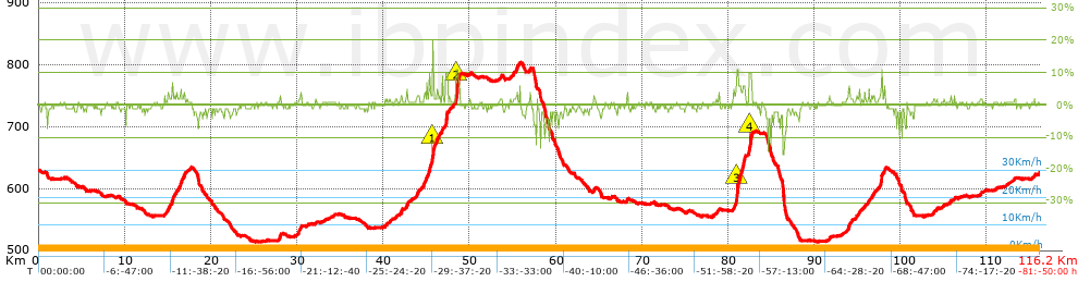
| Total length: 116.12 Km mi / ft ? |
| Analyzed distance: 116.12 Km |
| Lineal distance: 0.14 Km |
| Accumulated climb: 696.41 m |
info Points list |
| Accumulated descent: 693.12 m | |
| Maximum height: 803.93 m | |
| Minimal height: 513.6 m | |
| Start height: 629.1 m | |
| End height : 626 m | |
| Climb rate: 2.79 % | |
| Descent rate: 2.72 % | |
| Positive climb difference per Km: 6 m | |
| Negative descent difference per Km: 5.97 m | |
| Max slope filter: ~30 % |
| Min. points separation: ~30 m |
| Number of points: 8379 (cad. 13.86 m) |
| Significant points: 3339 (cad. 34.8 m / 39.85 %) |
| Direction changes per Km: 10.61 |
| Direction changes >5ş per Km: 2.72 |
| Accumulated straight stretches: 62.59 Km |
| Straight stretches per Km: 539.01 m |
| Penalizables slope changes: 13 |
| Penalizables slope changes per Km: 0.112 |
| Total time: 0 h |
| Time in movement: 0 h |
| Stopped time: 0 h |
| Total speed average: 0 Km/h |
| Average speed in movement : 0 Km/h |
| Maximum held speed: 0 Km/h |
Your fitness level
?*
|
 |
|
|
Remove track and analysis |
|
|
Save this trail on "My trails" |