Trail difficulty
135
BYC
|
| Track : subida_angliru.gpx |
|
These speeds are average for : Drawn track
(DRW) Reanalyze as HKG (Hiking) RNG (Running) |
| Penalty trail's conditions: 47 % ( > 50 % = MTB, < 50 % = RDB) |
|
|
| Level of correction applied to the trail: 0 |
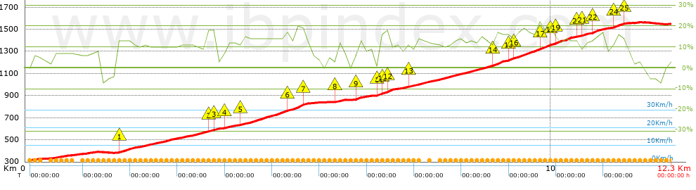
| Total length: 12.28 Km mi / ft ? |
| Analyzed distance: 12.28 Km |
| Lineal distance: 4.95 Km |
| Accumulated climb: 1264.6 m |
 info Points list info Points list |
| Accumulated descent: 34.7 m | |
| Maximum height: 1563.2 m | |
| Minimal height: 316.2 m | |
| Start height: 317.6 m | |
| End height : 1547.9 m | |
| Climb rate: 11.54 % | |
| Descent rate: 4.39 % | |
| Positive climb difference per Km: 102.98 m | |
| Negative descent difference per Km: 2.83 m | |
| Max slope filter: ~30 % |
| Min. points separation: ~30 m |
| Number of points: 514 (cad. 23.89 m) |
| Significant points: 263 (cad. 46.87 m / 51.17 %) |
| Direction changes per Km: 11.32 |
| Direction changes >5ş per Km: 10.34 |
| Accumulated straight stretches: 0.741 Km |
| Straight stretches per Km: 60.34 m |
| Penalizables slope changes: 3 |
| Penalizables slope changes per Km: 0.244 |
| Total time: 0 h |
| Time in movement: 0 h |
| Stopped time: 0 h |
| Total speed average: 0 Km/h |
| Average speed in movement : 0 Km/h |
| Maximum held speed: 0 Km/h |
Your fitness level
?*
|
 |
|
|
Remove track and analysis |
|
|
Save this trail on "My trails" |