Trail difficulty
81
BYC
|
| Track : hautacam_argel_s_gazost.gpx |
|
These speeds are average for : RNG
(Running) Reanalyze as HKG (Hiking) RNG (Running) |
| Penalty trail's conditions: 72 % ( > 50 % = MTB, < 50 % = RDB) |
|
|
| Level of correction applied to the trail: 0 |
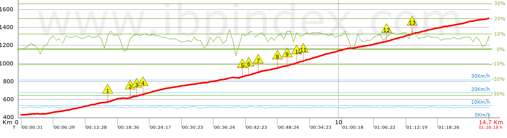
| Total length: 14.73 Km mi / ft ? |
| Analyzed distance: 14.73 Km |
| Lineal distance: 6.68 Km |
| Accumulated climb: 1076.8 m |
 info Points list info Points list |
| Accumulated descent: 5.8 m | |
| Maximum height: 1503.2 m | |
| Minimal height: 431.1 m | |
| Start height: 431.4 m | |
| End height : 1503.2 m | |
| Climb rate: 7.78 % | |
| Descent rate: 2.46 % | |
| Positive climb difference per Km: 73.1 m | |
| Negative descent difference per Km: 0.39 m | |
| Max slope filter: ~30 % |
| Min. points separation: ~30 m |
| Number of points: 796 (cad. 18.5 m) |
| Significant points: 371 (cad. 39.8 m / 46.61 %) |
| Direction changes per Km: 8.89 |
| Direction changes >5ş per Km: 7.13 |
| Accumulated straight stretches: 2.387 Km |
| Straight stretches per Km: 162.05 m |
| Penalizables slope changes: 1 |
| Penalizables slope changes per Km: 0.068 |
| Total time: 1:28:18 h |
| Time in movement: 1:28:18 h |
| Stopped time: 0:00:00 h |
| Total speed average: 10.01 Km/h |
| Average speed in movement : 10.01 Km/h |
| Maximum held speed: 10.84 Km/h |
Your fitness level
?*
|
 |
|
|
Remove track and analysis |
|
|
Save this trail on "My trails" |