Trail difficulty
36
BYC
|
| Track : acb003-vias-verdes-de-olloniego-cueva-de-la-lluera.gpx |
|
These speeds are average for : BYC
(Bicycle) Reanalyze as HKG (Hiking) RNG (Running) |
| Penalty trail's conditions: 42 % ( > 50 % = MTB, < 50 % = RDB) |
|
|
| Level of correction applied to the trail: 0 |
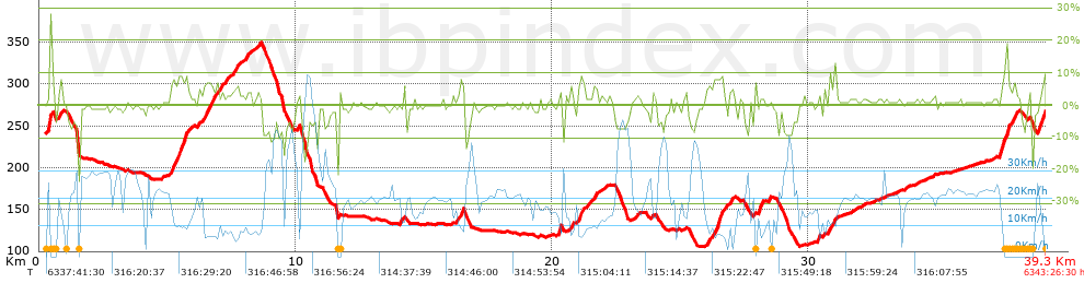
| Total length: 39.34 Km mi / ft ? |
| Analyzed distance: 39.34 Km |
| Lineal distance: 0 Km |
| Accumulated climb: 617.1 m |
 info Points list info Points list |
| Accumulated descent: 592.3 m | |
| Maximum height: 349.2 m | |
| Minimal height: 105.5 m | |
| Start height: 240.8 m | |
| End height : 266.5 m | |
| Climb rate: 3.91 % | |
| Descent rate: 5.04 % | |
| Positive climb difference per Km: 15.69 m | |
| Negative descent difference per Km: 15.06 m | |
| Max slope filter: ~30 % |
| Min. points separation: ~30 m |
| Number of points: 934 (cad. 42.12 m) |
| Significant points: 676 (cad. 58.27 m / 72.38 %) |
| Direction changes per Km: 6.69 |
| Direction changes >5ş per Km: 4.86 |
| Accumulated straight stretches: 6.674 Km |
| Straight stretches per Km: 169.65 m |
| Penalizables slope changes: 6 |
| Penalizables slope changes per Km: 0.153 |
| Total time: 6343:26:30 h |
| Time in movement: 2:20:35 h |
| Stopped time: 6341:05:55 h |
| Total speed average: 0.01 Km/h |
| Average speed in movement : 16.79 Km/h |
| Maximum held speed: 67.84 Km/h |
Your fitness level
14
|
 |
|
|
Remove track and analysis |
|
|
Save this trail on "My trails" |