Trail difficulty
?
DRW
|
| Track : 9-albacete-archena.gpx |
|
These speeds are average for : Drawn track
(DRW) Reanalyze as BYC (Bicycle) HKG (Hiking) RNG (Running) |
|
|
| Level of correction applied to the trail: 0 |
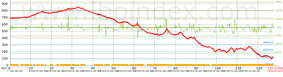
| Total length: 127.31 Km mi / ft ? |
| Analyzed distance: 127.31 Km |
| Lineal distance: 109.11 Km |
| Accumulated climb: 737 m |
 info Points list info Points list |
| Accumulated descent: 1319.2 m | |
| Maximum height: 852.5 m | |
| Minimal height: 97.7 m | |
| Start height: 691.3 m | |
| End height : 120.9 m | |
| Climb rate: 2.6 % | |
| Descent rate: 2.48 % | |
| Positive climb difference per Km: 5.79 m | |
| Negative descent difference per Km: 10.36 m | |
| Max slope filter: ~30 % |
| Min. points separation: ~30 m |
| Number of points: 541 (cad. 235.33 m) |
| Significant points: 513 (cad. 248.66 m / 94.82 %) |
| Direction changes per Km: 1.6 |
| Direction changes >5ş per Km: 1.27 |
| Accumulated straight stretches: 27.768 Km |
| Straight stretches per Km: 218.11 m |
| Penalizables slope changes: 12 |
| Penalizables slope changes per Km: 0.094 |
| Total time: 0 h |
| Time in movement: 0 h |
| Stopped time: 0 h |
| Total speed average: 0 Km/h |
| Average speed in movement : 0 Km/h |
| Maximum held speed: 0 Km/h |
 |
|
|
Remove track and analysis |
|
|
Save this trail on "My trails" |