Trail difficulty
?
DRW
|
| Track : 7-toledo-el_toboso.gpx |
|
These speeds are average for : Drawn track
(DRW) Reanalyze as BYC (Bicycle) HKG (Hiking) RNG (Running) |
|
|
| Level of correction applied to the trail: 0 |
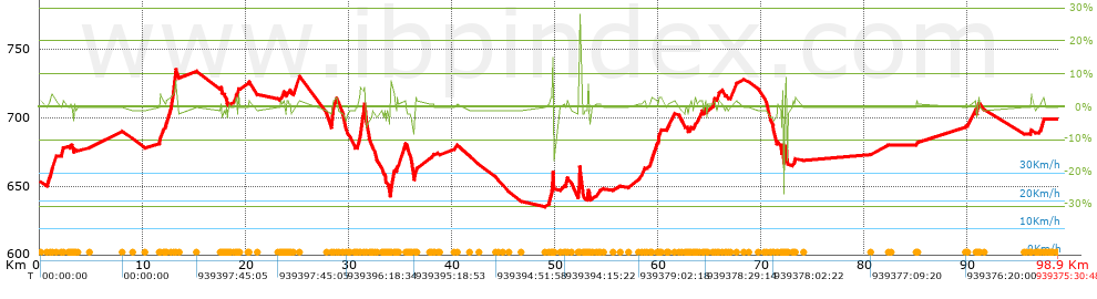
| Total length: 98.9 Km mi / ft ? |
| Analyzed distance: 98.9 Km |
| Lineal distance: 83.77 Km |
| Accumulated climb: 419.22 m |
 info Points list info Points list |
| Accumulated descent: 354.02 m | |
| Maximum height: 734.9 m | |
| Minimal height: 634.9 m | |
| Start height: 649.9 m | |
| End height : 698.9 m | |
| Climb rate: 2.74 % | |
| Descent rate: 2.27 % | |
| Positive climb difference per Km: 4.24 m | |
| Negative descent difference per Km: 3.58 m | |
| Max slope filter: ~30 % |
| Min. points separation: ~30 m |
| Number of points: 289 (cad. 342.21 m) |
| Significant points: 280 (cad. 355.75 m / 96.89 %) |
| Direction changes per Km: 1.51 |
| Direction changes >5ş per Km: 1.37 |
| Accumulated straight stretches: 16.544 Km |
| Straight stretches per Km: 167.28 m |
| Penalizables slope changes: 3 |
| Penalizables slope changes per Km: 0.03 |
| Total time: 939375:30:48 h |
| Time in movement: 0:00:00 h |
| Stopped time: 939375:30:48 h |
| Total speed average: 0 Km/h |
| Average speed in movement : 0 Km/h |
| Maximum held speed: 0 Km/h |
 |
|
|
Remove track and analysis |
|
|
Save this trail on "My trails" |