Trail difficulty
41
HKG
|
| Track : 814-La Vilaine et le chemin des Ker |
|
These speeds are average for : HKG
(Hiking) Reanalyze as BYC (Bicycle) RNG (Running) |
|
|
Level of correction applied to the trail:
4
 See original analysis (without corrections) See original analysis (without corrections)
|
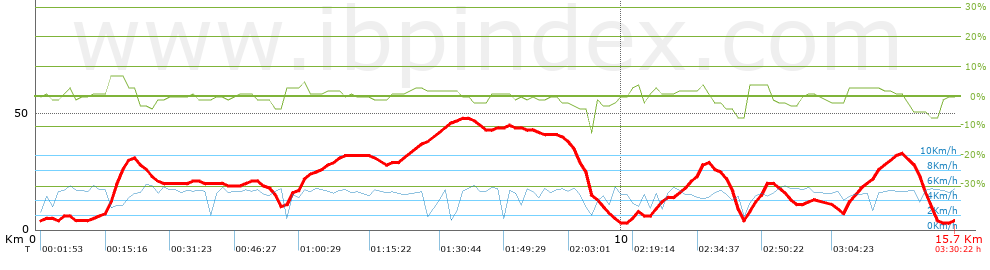
| Total length: 15.69 Km mi / ft ? |
| Analyzed distance: 15.69 Km |
| Lineal distance: 0 Km |
| Accumulated climb: 149.41 m |
info Points list |
| Accumulated descent: 151.38 m | |
| Maximum height: 47.91 m | |
| Minimal height: 2.89 m | |
| Start height: 3.5 m | |
| End height : 3.5 m | |
| Climb rate: 2.45 % | |
| Descent rate: 2.79 % | |
| Positive climb difference per Km: 9.52 m | |
| Negative descent difference per Km: 9.65 m | |
| Max slope filter: ~55 % |
| Min. points separation: ~30 m |
| Number of points: 361 (cad. 43.47 m) |
| Significant points: 259 (cad. 60.82 m / 71.75 %) |
| Direction changes per Km: 9.31 |
| Direction changes >5ş per Km: 8.8 |
| Accumulated straight stretches: 1.403 Km |
| Straight stretches per Km: 89.42 m |
| Penalizables slope changes: 0 |
| Penalizables slope changes per Km: 0 |
| Total time: 3:30:22 h |
| Time in movement: 3:30:22 h |
| Stopped time: 0:00:00 h |
| Total speed average: 4.48 Km/h |
| Average speed in movement : 4.48 Km/h |
| Maximum held speed: 6.21 Km/h |
 |
|
|
Remove track and analysis |
|
|
Save this trail on "My trails" |