User: Password:   Login   Login with Facebook   Register

Send to a friend
   

Detailed analysis of the trail analyzed as Bicycle (BYC)
Trail difficulty
45
BYC
Track : aragon-huesca-osqueta.gpx
These speeds are average for : BYC (Bicycle)
Reanalyze as
HKG (Hiking) RNG (Running)
 Penalty trail's conditions: 63 %   ( > 50 % = MTB, < 50 % = RDB)
 Reliability of the original trail: A   (716/82/0/-/-/82)
 Level of correction applied to the trail: 0
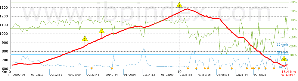
 Total length: 16.43 Km    mi / ft ?
 Analyzed distance: 16.43 Km
 Lineal distance: 0.01 Km
 Accumulated climb: 716 m  info Points list
 Accumulated descent: 715.4 m
 Maximum height: 1284.8 m
 Minimal height: 630 m
 Start height: 643.8 m
 End height : 645.8 m
 Climb rate: 7.25 %
 Descent rate: 12.21 %
 Positive climb difference per Km: 43.58 m
 Negative descent difference per Km: 43.54 m
 Max slope filter: ~30 %
 Min. points separation: ~30 m
 Number of points: 1067   (cad. 15.4 m)
 Significant points: 420   (cad. 39.21 m / 39.36 %)
 Direction changes per Km: 12.42
 Direction changes >5º per Km: 10.23
 Accumulated straight stretches: 2.079 Km
 Straight stretches per Km: 126.54 m
 Penalizables slope changes: 4
 Penalizables slope changes per Km: 0.243
 Total time: 3:13:50 h
 Time in movement: 2:09:26 h
 Stopped time: 1:04:24 h
 Total speed average: 5.09 Km/h
 Average speed in movement : 7.62 Km/h
 Maximum held speed: 32.46 Km/h
Your fitness level
?*
* fit = ? Not enought comparison elements or invalid track


Altitude Slope % Speed Km/h Speed < 2 Km/h

Steep slopes > 5%

Steep slopes >5% Steep slopes >10% Steep slopes >15% Steep slopes >20% Steep slopes >25%
 Steep slope of 124 m.  Average slope  Interval  Download as waypoint
1
 km 0.169  5%  124 m
 Steep slope of 730 m.  Average slope  Interval  Download as waypoint
2
 km 1.673  7%  730 m
 Steep slope of 177 m.  Average slope  Interval  Download as waypoint
3
 km 2.524  8%  177 m
 Steep slope of 630 m.  Average slope  Interval  Download as waypoint
4
 km 2.825  8%  630 m
 Steep slope of 389 m.  Average slope  Interval  Download as waypoint
5
 km 3.6  8%  389 m
 Steep slope of 1808 m.  Average slope  Interval  Download as waypoint
6
 km 4.09  8%  228 m
7
 km 4.318  10%  189 m
8
 km 4.507  9%  845 m
9
 km 5.352  12%  145 m
10
 km 5.497  9%  401 m
 Steep slope of 834 m.  Average slope  Interval  Download as waypoint
11
 km 6.114  8%  834 m
 Steep slope of 135 m.  Average slope  Interval  Download as waypoint
12
 km 7.106  5%  135 m
 Steep slope of 400 m.  Average slope  Interval  Download as waypoint
13
 km 7.92  7%  400 m
 Steep slope of 1948 m.  Average slope  Interval  Download as waypoint
14
 km 8.424  9%  1520 m
15
 km 9.944  11%  186 m
16
 km 10.13  8%  242 m
 Steep slope of 106 m.  Average slope  Interval  Download as waypoint
17
 km 16.195  17%  106 m


Compare this trail with...
Select trails to compare from "My trails". 
demo_montnegrebtt_2013.trk Ref.: 36172170671632
demo_matagalls_montserrat.trk Ref.: 36172170846048
demo_marathon_madrid_2013.trk Ref.: 36172170699197
Compare


Download (Registered users)

  GPX (.gpx)
  Garmin Training Center (.tcx)
  CompeGPS (.trk)
  OziExplorer (.plt)
  Google Earth (.kml)
  PDF analysis


Remove track and analysis
Save this trail on "My trails"


Send this analysis to a friend (Registered users)
Message that will receive your friend:
Re:
Hi.
(your name) has considered that this analysis of a trail could be of your interest.

(he/she will see a link to this page)
E-mail of your friend
You can enter multiple addresses separated by commas
Text
 
Send to a friend