Trail difficulty
261
RNG
|
| Track : 2019-05-12_09-27_sun.gpx |
|
These speeds are average for : BYC
(Bicycle) Reanalyze as BYC (Bicycle) HKG (Hiking) |
|
|
Level of correction applied to the trail:
6
 See original analysis (without corrections) See original analysis (without corrections)
|
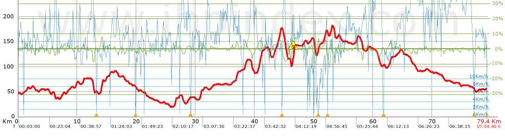
| Total length: 79.34 Km mi / ft ? |
| Analyzed distance: 79.34 Km |
| Lineal distance: 1.77 Km |
| Accumulated climb: 523.13 m |
info Points list |
| Accumulated descent: 501.32 m | |
| Maximum height: 182.21 m | |
| Minimal height: 19.4 m | |
| Start height: 46.7 m | |
| End height : 54.5 m | |
| Climb rate: 2.91 % | |
| Descent rate: 2.85 % | |
| Positive climb difference per Km: 6.59 m | |
| Negative descent difference per Km: 6.32 m | |
| Max slope filter: ~55 % |
| Min. points separation: ~30 m |
| Number of points: 4706 (cad. 16.86 m) |
| Significant points: 2082 (cad. 38.16 m / 44.24 %) |
| Direction changes per Km: 13.12 |
| Direction changes >5ş per Km: 2.23 |
| Accumulated straight stretches: 47.78 Km |
| Straight stretches per Km: 602.22 m |
| Penalizables slope changes: 4 |
| Penalizables slope changes per Km: 0.05 |
| Total time: 7:04:40 h |
| Time in movement: 4:25:19 h |
| Stopped time: 2:39:21 h |
| Total speed average: 11.21 Km/h |
| Average speed in movement : 17.94 Km/h |
| Maximum held speed: 47.02 Km/h |
 |
|
|
Remove track and analysis |
|
|
Save this trail on "My trails" |