User: Password:   Login   Login with Facebook   Register

Send to a friend
   

Detailed analysis of the trail analyzed as Bicycle (BYC)
Trail difficulty
82
BYC
Track : aragon-zaragoza-nueno-salto-roldan-pico-aguila.gpx
These speeds are average for : BYC (Bicycle)
Reanalyze as
HKG (Hiking) RNG (Running)
 Penalty trail's conditions: 63 %   ( > 50 % = MTB, < 50 % = RDB)
 Reliability of the original trail: A   (1326/82/0/-/-/82)
 Level of correction applied to the trail: 0
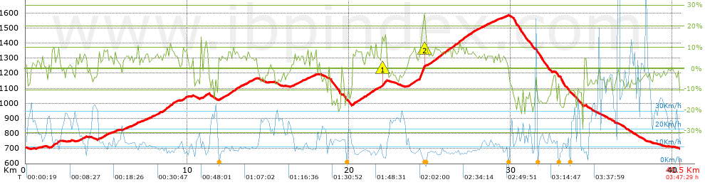
 Total length: 40.46 Km    mi / ft ?
 Analyzed distance: 40.46 Km
 Lineal distance: 0.09 Km
 Accumulated climb: 1325.49 m  info Points list
 Accumulated descent: 1328.29 m
 Maximum height: 1584.4 m
 Minimal height: 697.2 m
 Start height: 706.2 m
 End height : 700.4 m
 Climb rate: 6.25 %
 Descent rate: 8.08 %
 Positive climb difference per Km: 32.76 m
 Negative descent difference per Km: 32.83 m
 Max slope filter: ~30 %
 Min. points separation: ~30 m
 Number of points: 2295   (cad. 17.63 m)
 Significant points: 1034   (cad. 39.17 m / 45.05 %)
 Direction changes per Km: 10.48
 Direction changes >5º per Km: 8.06
 Accumulated straight stretches: 6.262 Km
 Straight stretches per Km: 154.77 m
 Penalizables slope changes: 10
 Penalizables slope changes per Km: 0.247
 Total time: 3:47:29 h
 Time in movement: 3:12:55 h
 Stopped time: 0:34:34 h
 Total speed average: 10.67 Km/h
 Average speed in movement : 12.58 Km/h
 Maximum held speed: 71.94 Km/h
Your fitness level
18


Altitude Slope % Speed Km/h Speed < 2 Km/h

Steep slopes > 5%

Steep slopes >5% Steep slopes >10% Steep slopes >15% Steep slopes >20% Steep slopes >25%
 Steep slope of 421 m.  Average slope  Interval  Download as waypoint
1
 km 1.621  7%  421 m
 Steep slope of 332 m.  Average slope  Interval  Download as waypoint
2
 km 3.345  6%  332 m
 Steep slope of 137 m.  Average slope  Interval  Download as waypoint
3
 km 4.52  6%  137 m
 Steep slope of 211 m.  Average slope  Interval  Download as waypoint
4
 km 4.845  8%  211 m
 Steep slope of 166 m.  Average slope  Interval  Download as waypoint
5
 km 5.483  6%  166 m
 Steep slope of 180 m.  Average slope  Interval  Download as waypoint
6
 km 6.12  5%  180 m
 Steep slope of 226 m.  Average slope  Interval  Download as waypoint
7
 km 6.666  6%  226 m
 Steep slope of 156 m.  Average slope  Interval  Download as waypoint
8
 km 7.434  6%  156 m
 Steep slope of 264 m.  Average slope  Interval  Download as waypoint
9
 km 7.762  6%  264 m
 Steep slope of 207 m.  Average slope  Interval  Download as waypoint
10
 km 8.132  7%  207 m
 Steep slope of 876 m.  Average slope  Interval  Download as waypoint
11
 km 8.463  6%  120 m
12
 km 8.583  8%  121 m
13
 km 8.703  8%  635 m
 Steep slope of 249 m.  Average slope  Interval  Download as waypoint
14
 km 9.733  8%  249 m
 Steep slope of 296 m.  Average slope  Interval  Download as waypoint
15
 km 10.973  8%  296 m
 Steep slope of 249 m.  Average slope  Interval  Download as waypoint
16
 km 11.935  6%  249 m
 Steep slope of 839 m.  Average slope  Interval  Download as waypoint
17
 km 12.297  7%  839 m
 Steep slope of 256 m.  Average slope  Interval  Download as waypoint
18
 km 13.285  6%  256 m
 Steep slope of 176 m.  Average slope  Interval  Download as waypoint
19
 km 13.701  7%  176 m
 Steep slope of 186 m.  Average slope  Interval  Download as waypoint
20
 km 16.412  5%  186 m
 Steep slope of 284 m.  Average slope  Interval  Download as waypoint
21
 km 16.819  6%  284 m
 Steep slope of 118 m.  Average slope  Interval  Download as waypoint
22
 km 17.631  5%  118 m
 Steep slope of 380 m.  Average slope  Interval  Download as waypoint
23
 km 20.207  8%  380 m
 Steep slope of 768 m.  Average slope  Interval  Download as waypoint
24
 km 20.707  7%  768 m
 Steep slope of 270 m.  Average slope  Interval  Download as waypoint
25
 km 21.591  7%  270 m
 Steep slope of 296 m.  Average slope  Interval  Download as waypoint
26
 km 22  8%  36 m
27
 km 22.037  14%  260 m
 Steep slope of 1033 m.  Average slope  Interval  Download as waypoint
28
 km 23.698  7%  692 m
29
 km 24.39  25%  341 m
 Steep slope of 3173 m.  Average slope  Interval  Download as waypoint
30
 km 24.823  8%  3173 m
 Steep slope of 510 m.  Average slope  Interval  Download as waypoint
31
 km 28.106  6%  510 m
 Steep slope of 94 m.  Average slope  Interval  Download as waypoint
32
 km 28.738  5%  94 m
 Steep slope of 112 m.  Average slope  Interval  Download as waypoint
33
 km 29.163  6%  112 m
 Steep slope of 159 m.  Average slope  Interval  Download as waypoint
34
 km 29.517  5%  159 m


Compare this trail with...
Select trails to compare from "My trails". 
demo_montnegrebtt_2013.trk Ref.: 36172170671632
demo_matagalls_montserrat.trk Ref.: 36172170846048
demo_marathon_madrid_2013.trk Ref.: 36172170699197
Compare


Download (Registered users)

  GPX (.gpx)
  Garmin Training Center (.tcx)
  CompeGPS (.trk)
  OziExplorer (.plt)
  Google Earth (.kml)
  PDF analysis


Remove track and analysis
Save this trail on "My trails"


Send this analysis to a friend (Registered users)
Message that will receive your friend:
Re:
Hi.
(your name) has considered that this analysis of a trail could be of your interest.

(he/she will see a link to this page)
E-mail of your friend
You can enter multiple addresses separated by commas
Text
 
Send to a friend