User: Password:   Login   Login with Facebook   Register

Send to a friend
   

Detailed analysis of the trail analyzed as Bicycle (BYC)
Trail difficulty
76
BYC
Track : madrid-valles-fuenfria-rio-moros.gpx
These speeds are average for : BYC (Bicycle)
Reanalyze as
HKG (Hiking) RNG (Running)
 Penalty trail's conditions: 55 %   ( > 50 % = MTB, < 50 % = RDB)
 Reliability of the original trail: A   (1168/78/0/-/-/78)
 Level of correction applied to the trail: 0
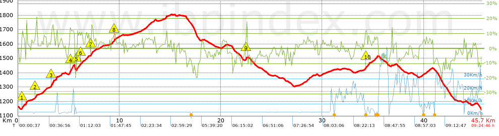
 Total length: 45.71 Km    mi / ft ?
 Analyzed distance: 45.71 Km
 Lineal distance: 0.24 Km
 Accumulated climb: 1167.8 m  info Points list
 Accumulated descent: 1193.2 m
 Maximum height: 1804.5 m
 Minimal height: 1144.2 m
 Start height: 1168.6 m
 End height : 1144.2 m
 Climb rate: 5.21 %
 Descent rate: 6.28 %
 Positive climb difference per Km: 25.55 m
 Negative descent difference per Km: 26.1 m
 Max slope filter: ~30 %
 Min. points separation: ~30 m
 Number of points: 3573   (cad. 12.79 m)
 Significant points: 1267   (cad. 36.11 m / 35.46 %)
 Direction changes per Km: 11.2
 Direction changes >5º per Km: 7.04
 Accumulated straight stretches: 8.612 Km
 Straight stretches per Km: 188.41 m
 Penalizables slope changes: 11
 Penalizables slope changes per Km: 0.241
 Total time: 9:24:46 h
 Time in movement: 7:05:48 h
 Stopped time: 2:18:58 h
 Total speed average: 4.86 Km/h
 Average speed in movement : 6.44 Km/h
 Maximum held speed: 52.89 Km/h
Your fitness level
100


Altitude Slope % Speed Km/h Speed < 2 Km/h

Steep slopes > 5%

Steep slopes >5% Steep slopes >10% Steep slopes >15% Steep slopes >20% Steep slopes >25%
 Steep slope of 462 m.  Average slope  Interval  Download as waypoint
1
 km 0.379  11%  201 m
2
 km 0.58  9%  97 m
3
 km 0.677  5%  130 m
4
 km 0.807  18%  34 m
 Steep slope of 270 m.  Average slope  Interval  Download as waypoint
5
 km 1.608  5%  103 m
6
 km 1.711  10%  102 m
7
 km 1.813  15%  65 m
 Steep slope of 345 m.  Average slope  Interval  Download as waypoint
8
 km 2.494  8%  345 m
 Steep slope of 370 m.  Average slope  Interval  Download as waypoint
9
 km 3.196  5%  70 m
10
 km 3.266  14%  300 m
 Steep slope of 211 m.  Average slope  Interval  Download as waypoint
11
 km 3.735  11%  211 m
 Steep slope of 464 m.  Average slope  Interval  Download as waypoint
12
 km 5.07  12%  464 m
 Steep slope of 571 m.  Average slope  Interval  Download as waypoint
13
 km 5.78  12%  166 m
14
 km 5.946  9%  238 m
15
 km 6.184  10%  134 m
16
 km 6.318  8%  33 m
 Steep slope of 303 m.  Average slope  Interval  Download as waypoint
17
 km 6.616  8%  303 m
 Steep slope of 272 m.  Average slope  Interval  Download as waypoint
18
 km 7.188  14%  170 m
19
 km 7.358  6%  102 m
 Steep slope of 453 m.  Average slope  Interval  Download as waypoint
20
 km 9.237  8%  240 m
21
 km 9.477  11%  142 m
22
 km 9.618  6%  71 m
 Steep slope of 107 m.  Average slope  Interval  Download as waypoint
23
 km 12.202  6%  107 m
 Steep slope of 841 m.  Average slope  Interval  Download as waypoint
24
 km 12.413  6%  841 m
 Steep slope of 168 m.  Average slope  Interval  Download as waypoint
25
 km 13.354  7%  168 m
 Steep slope of 232 m.  Average slope  Interval  Download as waypoint
26
 km 14.489  8%  232 m
 Steep slope of 290 m.  Average slope  Interval  Download as waypoint
27
 km 20.231  5%  290 m
 Steep slope of 182 m.  Average slope  Interval  Download as waypoint
28
 km 22.423  6%  72 m
29
 km 22.495  14%  110 m
 Steep slope of 135 m.  Average slope  Interval  Download as waypoint
30
 km 28.08  6%  135 m
 Steep slope of 546 m.  Average slope  Interval  Download as waypoint
31
 km 28.417  6%  546 m
 Steep slope of 506 m.  Average slope  Interval  Download as waypoint
32
 km 34.094  5%  134 m
33
 km 34.228  11%  136 m
34
 km 34.364  8%  236 m
 Steep slope of 404 m.  Average slope  Interval  Download as waypoint
35
 km 35.061  8%  404 m
 Steep slope of 217 m.  Average slope  Interval  Download as waypoint
36
 km 39.765  5%  217 m
 Steep slope of 134 m.  Average slope  Interval  Download as waypoint
37
 km 40.191  7%  134 m
 Steep slope of 172 m.  Average slope  Interval  Download as waypoint
38
 km 40.495  7%  172 m


Compare this trail with...
Select trails to compare from "My trails". 
demo_montnegrebtt_2013.trk Ref.: 36172170671632
demo_matagalls_montserrat.trk Ref.: 36172170846048
demo_marathon_madrid_2013.trk Ref.: 36172170699197
Compare


Download (Registered users)

  GPX (.gpx)
  Garmin Training Center (.tcx)
  CompeGPS (.trk)
  OziExplorer (.plt)
  Google Earth (.kml)
  PDF analysis


Remove track and analysis
Save this trail on "My trails"


Send this analysis to a friend (Registered users)
Message that will receive your friend:
Re:
Hi.
(your name) has considered that this analysis of a trail could be of your interest.

(he/she will see a link to this page)
E-mail of your friend
You can enter multiple addresses separated by commas
Text
 
Send to a friend