User: Password:   Login   Login with Facebook   Register

Send to a friend
   

Detailed analysis of the trail analyzed as Running (RNG)
Trail difficulty
657
RNG
Track : transpyr-etapa-02-camprodon-seu-durgell.gpx.gpx
These speeds are average for : BYC (Bicycle)
Reanalyze as
BYC (Bicycle) HKG (Hiking)
 Reliability of the original trail: A   (2813/75/0/-/-/75)
 Level of correction applied to the trail: 0
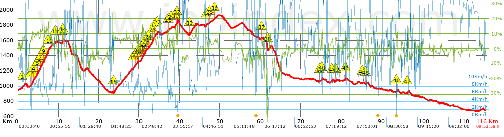
 Total length: 115.97 Km    mi / ft ?
 Analyzed distance: 115.97 Km
 Lineal distance: 73.99 Km
 Accumulated climb: 2813.7 m  info Points list
 Accumulated descent: 3037.9 m
 Maximum height: 1930.7 m
 Minimal height: 676.9 m
 Start height: 949.1 m
 End height : 686 m
 Climb rate: 6.13 %
 Descent rate: 6.11 %
 Positive climb difference per Km: 24.26 m
 Negative descent difference per Km: 26.2 m
 Max slope filter: ~55 %
 Min. points separation: ~30 m
 Number of points: 1485   (cad. 78.1 m)
 Significant points: 1339   (cad. 86.68 m / 90.17 %)
 Direction changes per Km: 5.85
 Direction changes >5º per Km: 5.41
 Accumulated straight stretches: 6.428 Km
 Straight stretches per Km: 55.43 m
 Penalizables slope changes: 27
 Penalizables slope changes per Km: 0.233
 Total time: 9:53:58 h
 Time in movement: 8:41:33 h
 Stopped time: 1:12:25 h
 Total speed average: 11.72 Km/h
 Average speed in movement : 13.34 Km/h
 Maximum held speed: 61.98 Km/h


Altitude Slope % Speed Km/h Speed < 0.5 Km/h

Steep slopes > 5%

Steep slopes >5% Steep slopes >10% Steep slopes >15% Steep slopes >20% Steep slopes >25%
 Steep slope of 722 m.  Average slope  Interval  Download as waypoint
1
 km 1.062  8%  722 m
 Steep slope of 3161 m.  Average slope  Interval  Download as waypoint
2
 km 3.048  7%  457 m
3
 km 3.505  12%  313 m
4
 km 3.818  9%  854 m
5
 km 4.671  11%  445 m
6
 km 5.117  7%  406 m
7
 km 5.522  12%  629 m
8
 km 6.151  9%  57 m
 Steep slope of 2102 m.  Average slope  Interval  Download as waypoint
9
 km 6.352  12%  1108 m
10
 km 7.461  10%  994 m
 Steep slope of 61 m.  Average slope  Interval  Download as waypoint
11
 km 9.193  11%  61 m
 Steep slope of 423 m.  Average slope  Interval  Download as waypoint
12
 km 10.853  9%  55 m
13
 km 10.908  13%  183 m
14
 km 11.091  7%  185 m
 Steep slope of 4152 m.  Average slope  Interval  Download as waypoint
15
 km 23.66  7%  4152 m
 Steep slope of 768 m.  Average slope  Interval  Download as waypoint
16
 km 28.512  7%  678 m
17
 km 29.19  11%  90 m
 Steep slope of 426 m.  Average slope  Interval  Download as waypoint
18
 km 29.572  5%  426 m
 Steep slope of 3748 m.  Average slope  Interval  Download as waypoint
19
 km 30.305  8%  160 m
20
 km 30.465  12%  552 m
21
 km 31.017  8%  443 m
22
 km 31.459  12%  243 m
23
 km 31.702  5%  478 m
24
 km 32.18  8%  1069 m
25
 km 33.249  13%  653 m
26
 km 33.902  6%  150 m
 Steep slope of 320 m.  Average slope  Interval  Download as waypoint
27
 km 34.396  8%  320 m
 Steep slope of 259 m.  Average slope  Interval  Download as waypoint
28
 km 37.125  14%  259 m
 Steep slope of 174 m.  Average slope  Interval  Download as waypoint
29
 km 37.848  5%  174 m
 Steep slope of 719 m.  Average slope  Interval  Download as waypoint
30
 km 38.808  8%  86 m
31
 km 38.894  11%  467 m
32
 km 39.361  29%  166 m
 Steep slope of 1794 m.  Average slope  Interval  Download as waypoint
33
 km 42.413  8%  1794 m
 Steep slope of 456 m.  Average slope  Interval  Download as waypoint
34
 km 46.449  7%  456 m
 Steep slope of 213 m.  Average slope  Interval  Download as waypoint
35
 km 47.435  7%  213 m
 Steep slope of 549 m.  Average slope  Interval  Download as waypoint
36
 km 48.652  5%  549 m
 Steep slope of 352 m.  Average slope  Interval  Download as waypoint
37
 km 60.199  6%  352 m
 Steep slope of 687 m.  Average slope  Interval  Download as waypoint
38
 km 61.891  8%  687 m
 Steep slope of 149 m.  Average slope  Interval  Download as waypoint
39
 km 74.623  8%  149 m
 Steep slope of 315 m.  Average slope  Interval  Download as waypoint
40
 km 75.194  9%  315 m
 Steep slope of 392 m.  Average slope  Interval  Download as waypoint
41
 km 77.594  6%  392 m
 Steep slope of 476 m.  Average slope  Interval  Download as waypoint
42
 km 78.57  6%  476 m
 Steep slope of 219 m.  Average slope  Interval  Download as waypoint
43
 km 81.069  8%  219 m
 Steep slope of 193 m.  Average slope  Interval  Download as waypoint
44
 km 85.146  7%  193 m
 Steep slope of 269 m.  Average slope  Interval  Download as waypoint
45
 km 86.063  7%  269 m
 Steep slope of 346 m.  Average slope  Interval  Download as waypoint
46
 km 93.648  9%  346 m
 Steep slope of 240 m.  Average slope  Interval  Download as waypoint
47
 km 96.386  7%  240 m


Compare this trail with...
Select trails to compare from "My trails". 
demo_montnegrebtt_2013.trk Ref.: 36172170671632
demo_matagalls_montserrat.trk Ref.: 36172170846048
demo_marathon_madrid_2013.trk Ref.: 36172170699197
Compare


Download (Registered users)

  GPX (.gpx)
  Garmin Training Center (.tcx)
  CompeGPS (.trk)
  OziExplorer (.plt)
  Google Earth (.kml)
  PDF analysis


Remove track and analysis
Save this trail on "My trails"


Send this analysis to a friend (Registered users)
Message that will receive your friend:
Re:
Hi.
(your name) has considered that this analysis of a trail could be of your interest.

(he/she will see a link to this page)
E-mail of your friend
You can enter multiple addresses separated by commas
Text
 
Send to a friend