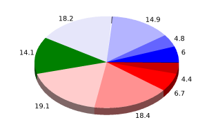
User: Password:   Login   Login with Facebook   Register

Send to a friend
   

Detailed analysis of the trail analyzed as Bicycle (BYC)
Trail difficulty
263
BYC
Track : transpyr-etapa03-seu-durgell-pont-de-suert.gpx
These speeds are average for : BYC (Bicycle)
Reanalyze as
HKG (Hiking) RNG (Running)
 Penalty trail's conditions: 66 %   ( > 50 % = MTB, < 50 % = RDB)
 Reliability of the original trail: A   (3564/75/0/-/-/75)
 Level of correction applied to the trail: 0
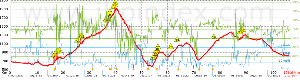
 Total length: 106.56 Km    mi / ft ?
 Analyzed distance: 106.56 Km
 Lineal distance: 60.04 Km
 Accumulated climb: 3546.47 m  info Points list
 Accumulated descent: 3379.04 m
 Maximum height: 1911.4 m
 Minimal height: 575 m
 Start height: 685.9 m
 End height : 841.8 m
 Climb rate: 7.3 %
 Descent rate: 7.69 %
 Positive climb difference per Km: 33.28 m
 Negative descent difference per Km: 31.71 m
 Max slope filter: ~30 %
 Min. points separation: ~30 m
 Number of points: 1563   (cad. 68.18 m)
 Significant points: 1384   (cad. 77.05 m / 88.55 %)
 Direction changes per Km: 7.51
 Direction changes >5º per Km: 6.82
 Accumulated straight stretches: 5.246 Km
 Straight stretches per Km: 49.23 m
 Penalizables slope changes: 28
 Penalizables slope changes per Km: 0.263
 Total time: 10:03:10 h
 Time in movement: 8:49:05 h
 Stopped time: 1:14:05 h
 Total speed average: 10.6 Km/h
 Average speed in movement : 12.08 Km/h
 Maximum held speed: 48.19 Km/h
Your fitness level
59


Altitude Slope % Speed Km/h Speed < 2 Km/h

Steep slopes > 5%

Steep slopes >5% Steep slopes >10% Steep slopes >15% Steep slopes >20% Steep slopes >25%
 Steep slope of 184 m.  Average slope  Interval  Download as waypoint
1
 km 6.599  10%  184 m
 Steep slope of 509 m.  Average slope  Interval  Download as waypoint
2
 km 8.853  7%  509 m
 Steep slope of 225 m.  Average slope  Interval  Download as waypoint
3
 km 14.189  6%  225 m
 Steep slope of 305 m.  Average slope  Interval  Download as waypoint
4
 km 16.25  6%  70 m
5
 km 16.32  14%  235 m
 Steep slope of 148 m.  Average slope  Interval  Download as waypoint
6
 km 16.755  11%  52 m
7
 km 16.808  22%  96 m
 Steep slope of 268 m.  Average slope  Interval  Download as waypoint
8
 km 17.112  8%  184 m
9
 km 17.296  13%  84 m
 Steep slope of 127 m.  Average slope  Interval  Download as waypoint
10
 km 17.504  13%  38 m
11
 km 17.542  28%  89 m
 Steep slope of 69 m.  Average slope  Interval  Download as waypoint
12
 km 17.805  18%  69 m
 Steep slope of 37 m.  Average slope  Interval  Download as waypoint
13
 km 18.445  20%  37 m
 Steep slope of 182 m.  Average slope  Interval  Download as waypoint
14
 km 18.747  13%  45 m
15
 km 18.792  13%  137 m
 Steep slope of 646 m.  Average slope  Interval  Download as waypoint
16
 km 20.599  8%  646 m
 Steep slope of 228 m.  Average slope  Interval  Download as waypoint
17
 km 22.544  11%  228 m
 Steep slope of 382 m.  Average slope  Interval  Download as waypoint
18
 km 23.322  5%  382 m
 Steep slope of 207 m.  Average slope  Interval  Download as waypoint
19
 km 24.035  8%  207 m
 Steep slope of 784 m.  Average slope  Interval  Download as waypoint
20
 km 24.781  7%  655 m
21
 km 25.436  24%  129 m
 Steep slope of 1095 m.  Average slope  Interval  Download as waypoint
22
 km 25.658  5%  617 m
23
 km 26.275  14%  275 m
24
 km 26.55  18%  103 m
25
 km 26.653  12%  100 m
 Steep slope of 881 m.  Average slope  Interval  Download as waypoint
26
 km 27.261  16%  144 m
27
 km 27.406  6%  331 m
28
 km 27.737  10%  406 m
 Steep slope of 187 m.  Average slope  Interval  Download as waypoint
29
 km 29.437  10%  187 m
 Steep slope of 298 m.  Average slope  Interval  Download as waypoint
30
 km 30.062  6%  298 m
 Steep slope of 297 m.  Average slope  Interval  Download as waypoint
31
 km 30.712  10%  297 m
 Steep slope of 346 m.  Average slope  Interval  Download as waypoint
32
 km 31.311  5%  346 m
 Steep slope of 413 m.  Average slope  Interval  Download as waypoint
33
 km 32.523  5%  413 m
 Steep slope of 316 m.  Average slope  Interval  Download as waypoint
34
 km 33.358  8%  316 m
 Steep slope of 533 m.  Average slope  Interval  Download as waypoint
35
 km 34.136  10%  533 m
 Steep slope of 379 m.  Average slope  Interval  Download as waypoint
36
 km 35.041  6%  379 m
 Steep slope of 917 m.  Average slope  Interval  Download as waypoint
37
 km 35.729  7%  594 m
38
 km 36.323  14%  323 m
 Steep slope of 1714 m.  Average slope  Interval  Download as waypoint
39
 km 36.861  8%  212 m
40
 km 37.073  13%  301 m
41
 km 37.374  8%  167 m
42
 km 37.541  15%  360 m
43
 km 37.9  11%  401 m
44
 km 38.302  5%  273 m
 Steep slope of 208 m.  Average slope  Interval  Download as waypoint
45
 km 38.818  9%  208 m
 Steep slope of 722 m.  Average slope  Interval  Download as waypoint
46
 km 39.283  13%  287 m
47
 km 39.569  17%  324 m
48
 km 39.893  10%  111 m
 Steep slope of 2497 m.  Average slope  Interval  Download as waypoint
49
 km 54.118  9%  275 m
50
 km 54.393  11%  721 m
51
 km 55.114  16%  320 m
52
 km 55.434  15%  245 m
53
 km 55.679  13%  169 m
54
 km 55.848  9%  49 m
55
 km 55.897  15%  65 m
56
 km 55.963  16%  267 m
57
 km 56.23  12%  183 m
58
 km 56.413  11%  203 m
 Steep slope of 724 m.  Average slope  Interval  Download as waypoint
59
 km 60.615  9%  517 m
60
 km 61.132  13%  207 m
 Steep slope of 396 m.  Average slope  Interval  Download as waypoint
61
 km 61.546  6%  396 m
 Steep slope of 1160 m.  Average slope  Interval  Download as waypoint
62
 km 62.819  8%  802 m
63
 km 63.621  10%  272 m
64
 km 63.893  6%  86 m
 Steep slope of 688 m.  Average slope  Interval  Download as waypoint
65
 km 65.708  6%  688 m
 Steep slope of 306 m.  Average slope  Interval  Download as waypoint
66
 km 66.847  7%  306 m
 Steep slope of 1751 m.  Average slope  Interval  Download as waypoint
67
 km 72.18  5%  134 m
68
 km 72.313  14%  51 m
69
 km 72.365  6%  1566 m
 Steep slope of 1271 m.  Average slope  Interval  Download as waypoint
70
 km 74.449  7%  1271 m
 Steep slope of 1265 m.  Average slope  Interval  Download as waypoint
71
 km 75.895  7%  1265 m
 Steep slope of 1005 m.  Average slope  Interval  Download as waypoint
72
 km 77.46  7%  154 m
73
 km 77.614  11%  311 m
74
 km 77.925  10%  540 m
 Steep slope of 599 m.  Average slope  Interval  Download as waypoint
75
 km 79.433  9%  599 m
 Steep slope of 402 m.  Average slope  Interval  Download as waypoint
76
 km 81.082  6%  402 m
 Steep slope of 205 m.  Average slope  Interval  Download as waypoint
77
 km 87.743  12%  143 m
78
 km 87.886  15%  62 m
 Steep slope of 541 m.  Average slope  Interval  Download as waypoint
79
 km 88.321  6%  331 m
80
 km 88.652  12%  210 m
 Steep slope of 249 m.  Average slope  Interval  Download as waypoint
81
 km 89.275  5%  249 m
 Steep slope of 316 m.  Average slope  Interval  Download as waypoint
82
 km 104.099  9%  316 m


Compare this trail with...
Select trails to compare from "My trails". 
demo_montnegrebtt_2013.trk Ref.: 36172170671632
demo_matagalls_montserrat.trk Ref.: 36172170846048
demo_marathon_madrid_2013.trk Ref.: 36172170699197
Compare


Download (Registered users)

  GPX (.gpx)
  Garmin Training Center (.tcx)
  CompeGPS (.trk)
  OziExplorer (.plt)
  Google Earth (.kml)
  PDF analysis


Remove track and analysis
Save this trail on "My trails"


Send this analysis to a friend (Registered users)
Message that will receive your friend:
Re:
Hi.
(your name) has considered that this analysis of a trail could be of your interest.

(he/she will see a link to this page)
E-mail of your friend
You can enter multiple addresses separated by commas
Text
 
Send to a friend