User: Password:   Login   Login with Facebook   Register

Send to a friend
   

Detailed analysis of the trail analyzed as Bicycle (BYC)
Trail difficulty
202
BYC
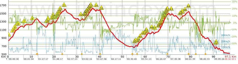
Track : transpyr-etapa04-pont-de-suert-ainsa.gpx
These speeds are average for : BYC (Bicycle)
Reanalyze as
HKG (Hiking) RNG (Running)
 Penalty trail's conditions: 62 %   ( > 50 % = MTB, < 50 % = RDB)
 Reliability of the original trail: A   (2962/83/0/-/-/83)
 Level of correction applied to the trail: 0
 Total length: 97.07 Km    mi / ft ?
 Analyzed distance: 97.07 Km
 Lineal distance: 48.98 Km
 Accumulated climb: 2960.6 m  info Points list
 Accumulated descent: 3250.7 m
 Maximum height: 1630.1 m
 Minimal height: 527.5 m
 Start height: 838.5 m
 End height : 528.4 m
 Climb rate: 7.19 %
 Descent rate: 7.04 %
 Positive climb difference per Km: 30.5 m
 Negative descent difference per Km: 33.49 m
 Max slope filter: ~30 %
 Min. points separation: ~30 m
 Number of points: 1426   (cad. 68.07 m)
 Significant points: 1265   (cad. 76.79 m / 88.71 %)
 Direction changes per Km: 7.11
 Direction changes >5º per Km: 6.57
 Accumulated straight stretches: 6.379 Km
 Straight stretches per Km: 65.72 m
 Penalizables slope changes: 23
 Penalizables slope changes per Km: 0.237
 Total time: 9:34:33 h
 Time in movement: 7:59:00 h
 Stopped time: 1:35:33 h
 Total speed average: 10.14 Km/h
 Average speed in movement : 12.16 Km/h
 Maximum held speed: 54.6 Km/h
Your fitness level
63


Altitude Slope % Speed Km/h Speed < 2 Km/h

Steep slopes > 10%

Steep slopes >5% Steep slopes >10% Steep slopes >15% Steep slopes >20% Steep slopes >25%
 Steep slope of 1267 m.  Average slope  Interval  Download as waypoint
1
 km 1.758  11%  596 m
2
 km 2.354  10%  414 m
3
 km 2.768  17%  257 m
 Steep slope of 294 m.  Average slope  Interval  Download as waypoint
4
 km 4.275  11%  294 m
 Steep slope of 339 m.  Average slope  Interval  Download as waypoint
5
 km 16.981  10%  339 m
 Steep slope of 252 m.  Average slope  Interval  Download as waypoint
6
 km 19.298  25%  190 m
7
 km 19.488  11%  62 m
 Steep slope of 1251 m.  Average slope  Interval  Download as waypoint
8
 km 21.357  11%  335 m
9
 km 21.692  10%  560 m
10
 km 22.252  12%  356 m
 Steep slope of 840 m.  Average slope  Interval  Download as waypoint
11
 km 33.302  12%  259 m
12
 km 33.982  12%  207 m
13
 km 35.055  10%  155 m
14
 km 35.563  10%  219 m
 Steep slope of 176 m.  Average slope  Interval  Download as waypoint
15
 km 55.66  10%  176 m
 Steep slope of 556 m.  Average slope  Interval  Download as waypoint
16
 km 56.555  10%  309 m
17
 km 60.341  10%  247 m
 Steep slope of 2633 m.  Average slope  Interval  Download as waypoint
18
 km 66.506  11%  135 m
19
 km 66.641  16%  116 m
20
 km 66.757  13%  157 m
21
 km 67.208  12%  613 m
22
 km 67.821  15%  234 m
23
 km 68.055  13%  302 m
24
 km 68.357  10%  318 m
25
 km 68.675  11%  402 m
26
 km 69.077  10%  193 m
27
 km 69.271  11%  163 m
 Steep slope of 163 m.  Average slope  Interval  Download as waypoint
28
 km 76.091  10%  163 m
 Steep slope of 282 m.  Average slope  Interval  Download as waypoint
29
 km 90.883  10%  282 m


Compare this trail with...
Select trails to compare from "My trails". 
demo_montnegrebtt_2013.trk Ref.: 36172170671632
demo_matagalls_montserrat.trk Ref.: 36172170846048
demo_marathon_madrid_2013.trk Ref.: 36172170699197
Compare


Download (Registered users)

  GPX (.gpx)
  Garmin Training Center (.tcx)
  CompeGPS (.trk)
  OziExplorer (.plt)
  Google Earth (.kml)
  PDF analysis


Remove track and analysis
Save this trail on "My trails"


Send this analysis to a friend (Registered users)
Message that will receive your friend:
Re:
Hi.
(your name) has considered that this analysis of a trail could be of your interest.

(he/she will see a link to this page)
E-mail of your friend
You can enter multiple addresses separated by commas
Text
 
Send to a friend