User: Password:   Login   Login with Facebook   Register

Send to a friend
   

Detailed analysis of the trail analyzed as Running (RNG)
Trail difficulty
598
RNG
Track : transpyr-etapa04-pont-de-suert-ainsa.gpx
These speeds are average for : BYC (Bicycle)
Reanalyze as
BYC (Bicycle) HKG (Hiking)
 Reliability of the original trail: A   (2962/83/0/-/-/83)
 Level of correction applied to the trail: 0
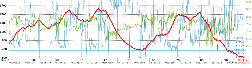
 Total length: 97.07 Km    mi / ft ?
 Analyzed distance: 97.07 Km
 Lineal distance: 48.98 Km
 Accumulated climb: 2961.7 m  info Points list
 Accumulated descent: 3251.8 m
 Maximum height: 1630.1 m
 Minimal height: 527.5 m
 Start height: 838.5 m
 End height : 528.4 m
 Climb rate: 7.18 %
 Descent rate: 7.06 %
 Positive climb difference per Km: 30.51 m
 Negative descent difference per Km: 33.5 m
 Max slope filter: ~55 %
 Min. points separation: ~30 m
 Number of points: 1426   (cad. 68.07 m)
 Significant points: 1265   (cad. 76.8 m / 88.71 %)
 Direction changes per Km: 7.11
 Direction changes >5º per Km: 6.57
 Accumulated straight stretches: 6.379 Km
 Straight stretches per Km: 65.72 m
 Penalizables slope changes: 23
 Penalizables slope changes per Km: 0.237
 Total time: 9:34:33 h
 Time in movement: 8:12:48 h
 Stopped time: 1:21:45 h
 Total speed average: 10.14 Km/h
 Average speed in movement : 11.82 Km/h
 Maximum held speed: 54.6 Km/h


Altitude Slope % Speed Km/h Speed < 0.5 Km/h

Steep slopes > 5%

Steep slopes >5% Steep slopes >10% Steep slopes >15% Steep slopes >20% Steep slopes >25%
 Steep slope of 978 m.  Average slope  Interval  Download as waypoint
1
 km 0.08  6%  978 m
 Steep slope of 1204 m.  Average slope  Interval  Download as waypoint
2
 km 1.758  11%  596 m
3
 km 2.354  10%  414 m
4
 km 2.768  16%  194 m
 Steep slope of 213 m.  Average slope  Interval  Download as waypoint
5
 km 3.745  8%  213 m
 Steep slope of 294 m.  Average slope  Interval  Download as waypoint
6
 km 4.275  11%  294 m
 Steep slope of 757 m.  Average slope  Interval  Download as waypoint
7
 km 6.796  7%  757 m
 Steep slope of 1686 m.  Average slope  Interval  Download as waypoint
8
 km 10.481  8%  1686 m
 Steep slope of 1053 m.  Average slope  Interval  Download as waypoint
9
 km 16.712  6%  269 m
10
 km 16.981  10%  339 m
11
 km 17.32  8%  445 m
 Steep slope of 490 m.  Average slope  Interval  Download as waypoint
12
 km 19.062  7%  236 m
13
 km 19.298  25%  192 m
14
 km 19.49  9%  62 m
 Steep slope of 1359 m.  Average slope  Interval  Download as waypoint
15
 km 20.468  8%  891 m
16
 km 21.359  11%  335 m
17
 km 21.694  12%  133 m
 Steep slope of 1460 m.  Average slope  Interval  Download as waypoint
18
 km 22.056  10%  198 m
19
 km 22.254  12%  356 m
20
 km 22.61  8%  906 m
 Steep slope of 605 m.  Average slope  Interval  Download as waypoint
21
 km 24.252  8%  605 m
 Steep slope of 587 m.  Average slope  Interval  Download as waypoint
22
 km 31.638  6%  587 m
 Steep slope of 172 m.  Average slope  Interval  Download as waypoint
23
 km 33.304  12%  172 m
 Steep slope of 294 m.  Average slope  Interval  Download as waypoint
24
 km 33.564  5%  120 m
25
 km 33.684  8%  174 m
 Steep slope of 245 m.  Average slope  Interval  Download as waypoint
26
 km 33.984  12%  207 m
27
 km 34.191  11%  38 m
 Steep slope of 1526 m.  Average slope  Interval  Download as waypoint
28
 km 34.406  8%  651 m
29
 km 35.058  10%  155 m
30
 km 35.212  8%  353 m
31
 km 35.565  10%  219 m
32
 km 35.784  9%  148 m
 Steep slope of 767 m.  Average slope  Interval  Download as waypoint
33
 km 36.102  8%  767 m
 Steep slope of 357 m.  Average slope  Interval  Download as waypoint
34
 km 38.422  10%  357 m
 Steep slope of 195 m.  Average slope  Interval  Download as waypoint
35
 km 40.728  5%  195 m
 Steep slope of 507 m.  Average slope  Interval  Download as waypoint
36
 km 55.332  6%  331 m
37
 km 55.663  10%  176 m
 Steep slope of 768 m.  Average slope  Interval  Download as waypoint
38
 km 56.558  10%  309 m
39
 km 56.867  11%  459 m
 Steep slope of 788 m.  Average slope  Interval  Download as waypoint
40
 km 57.749  6%  788 m
 Steep slope of 258 m.  Average slope  Interval  Download as waypoint
41
 km 58.844  7%  258 m
 Steep slope of 484 m.  Average slope  Interval  Download as waypoint
42
 km 59.639  8%  484 m
 Steep slope of 1086 m.  Average slope  Interval  Download as waypoint
43
 km 60.281  10%  63 m
44
 km 60.344  10%  247 m
45
 km 60.591  9%  776 m
 Steep slope of 354 m.  Average slope  Interval  Download as waypoint
46
 km 62.775  7%  354 m
 Steep slope of 360 m.  Average slope  Interval  Download as waypoint
47
 km 64.105  7%  360 m
 Steep slope of 395 m.  Average slope  Interval  Download as waypoint
48
 km 65.725  7%  395 m
 Steep slope of 3047 m.  Average slope  Interval  Download as waypoint
49
 km 66.428  9%  82 m
50
 km 66.51  11%  135 m
51
 km 66.644  16%  116 m
52
 km 66.76  13%  157 m
53
 km 66.917  7%  295 m
54
 km 67.211  12%  613 m
55
 km 67.824  15%  234 m
56
 km 68.058  13%  302 m
57
 km 68.36  10%  318 m
58
 km 68.679  11%  402 m
59
 km 69.081  10%  193 m
60
 km 69.274  11%  163 m
61
 km 69.437  15%  37 m
 Steep slope of 225 m.  Average slope  Interval  Download as waypoint
62
 km 69.752  5%  225 m
 Steep slope of 340 m.  Average slope  Interval  Download as waypoint
63
 km 71.372  7%  340 m
 Steep slope of 360 m.  Average slope  Interval  Download as waypoint
64
 km 75.371  7%  360 m
 Steep slope of 601 m.  Average slope  Interval  Download as waypoint
65
 km 76.001  8%  93 m
66
 km 76.094  10%  163 m
67
 km 76.257  7%  345 m
 Steep slope of 854 m.  Average slope  Interval  Download as waypoint
68
 km 77.327  6%  854 m
 Steep slope of 271 m.  Average slope  Interval  Download as waypoint
69
 km 78.84  6%  271 m
 Steep slope of 383 m.  Average slope  Interval  Download as waypoint
70
 km 90.889  10%  282 m
71
 km 91.17  12%  101 m


Compare this trail with...
Select trails to compare from "My trails". 
demo_montnegrebtt_2013.trk Ref.: 36172170671632
demo_matagalls_montserrat.trk Ref.: 36172170846048
demo_marathon_madrid_2013.trk Ref.: 36172170699197
Compare


Download (Registered users)

  GPX (.gpx)
  Garmin Training Center (.tcx)
  CompeGPS (.trk)
  OziExplorer (.plt)
  Google Earth (.kml)
  PDF analysis


Remove track and analysis
Save this trail on "My trails"


Send this analysis to a friend (Registered users)
Message that will receive your friend:
Re:
Hi.
(your name) has considered that this analysis of a trail could be of your interest.

(he/she will see a link to this page)
E-mail of your friend
You can enter multiple addresses separated by commas
Text
 
Send to a friend