User: Password:   Login   Login with Facebook   Register

Send to a friend
   

Detailed analysis of the trail analyzed as Bicycle (BYC)
Trail difficulty
237
BYC
Track : transpyr-etapa06-jaca-burguete-auritz.gpx.gpx
These speeds are average for : BYC (Bicycle)
Reanalyze as
HKG (Hiking) RNG (Running)
 Penalty trail's conditions: 49 %   ( > 50 % = MTB, < 50 % = RDB)
 Reliability of the original trail: B   (3261/71/0/-/-/71)
 Level of correction applied to the trail: 0
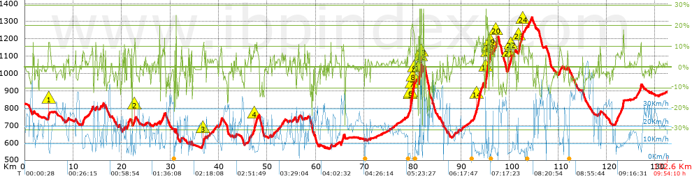
 Total length: 132.59 Km    mi / ft ?
 Analyzed distance: 132.59 Km
 Lineal distance: 78.91 Km
 Accumulated climb: 3252.7 m  info Points list
 Accumulated descent: 3199.6 m
 Maximum height: 1322.7 m
 Minimal height: 565.2 m
 Start height: 824.3 m
 End height : 894.4 m
 Climb rate: 5.85 %
 Descent rate: 5.94 %
 Positive climb difference per Km: 24.53 m
 Negative descent difference per Km: 24.13 m
 Max slope filter: ~30 %
 Min. points separation: ~30 m
 Number of points: 1540   (cad. 86.1 m)
 Significant points: 1419   (cad. 93.5 m / 92.14 %)
 Direction changes per Km: 5.82
 Direction changes >5º per Km: 5.13
 Accumulated straight stretches: 9.725 Km
 Straight stretches per Km: 73.35 m
 Penalizables slope changes: 30
 Penalizables slope changes per Km: 0.226
 Total time: 9:54:10 h
 Time in movement: 8:44:26 h
 Stopped time: 1:09:44 h
 Total speed average: 13.39 Km/h
 Average speed in movement : 15.17 Km/h
 Maximum held speed: 59.15 Km/h
Your fitness level
47


Altitude Slope % Speed Km/h Speed < 2 Km/h

Steep slopes > 10%

Steep slopes >5% Steep slopes >10% Steep slopes >15% Steep slopes >20% Steep slopes >25%
 Steep slope of 249 m.  Average slope  Interval  Download as waypoint
1
 km 4.918  12%  249 m
 Steep slope of 166 m.  Average slope  Interval  Download as waypoint
2
 km 22.664  12%  166 m
 Steep slope of 335 m.  Average slope  Interval  Download as waypoint
3
 km 36.697  11%  335 m
 Steep slope of 380 m.  Average slope  Interval  Download as waypoint
4
 km 47.368  11%  380 m
 Steep slope of 972 m.  Average slope  Interval  Download as waypoint
5
 km 79.472  11%  97 m
6
 km 79.569  17%  135 m
7
 km 79.704  19%  292 m
8
 km 79.996  18%  363 m
9
 km 80.359  14%  85 m
 Steep slope of 479 m.  Average slope  Interval  Download as waypoint
10
 km 81.245  11%  117 m
11
 km 81.361  26%  107 m
12
 km 81.617  28%  185 m
13
 km 81.802  28%  70 m
 Steep slope of 776 m.  Average slope  Interval  Download as waypoint
14
 km 93.122  13%  776 m
 Steep slope of 949 m.  Average slope  Interval  Download as waypoint
15
 km 95.003  22%  439 m
16
 km 95.442  15%  173 m
17
 km 95.615  20%  58 m
18
 km 95.782  17%  173 m
19
 km 95.955  14%  106 m
 Steep slope of 524 m.  Average slope  Interval  Download as waypoint
20
 km 97.101  13%  524 m
 Steep slope of 441 m.  Average slope  Interval  Download as waypoint
21
 km 99.78  10%  166 m
22
 km 100.191  12%  275 m
 Steep slope of 874 m.  Average slope  Interval  Download as waypoint
23
 km 101.849  13%  550 m
24
 km 102.594  11%  324 m


Compare this trail with...
Select trails to compare from "My trails". 
demo_montnegrebtt_2013.trk Ref.: 36172170671632
demo_matagalls_montserrat.trk Ref.: 36172170846048
demo_marathon_madrid_2013.trk Ref.: 36172170699197
Compare


Download (Registered users)

  GPX (.gpx)
  Garmin Training Center (.tcx)
  CompeGPS (.trk)
  OziExplorer (.plt)
  Google Earth (.kml)
  PDF analysis


Remove track and analysis
Save this trail on "My trails"


Send this analysis to a friend (Registered users)
Message that will receive your friend:
Re:
Hi.
(your name) has considered that this analysis of a trail could be of your interest.

(he/she will see a link to this page)
E-mail of your friend
You can enter multiple addresses separated by commas
Text
 
Send to a friend