User: Password:   Login   Login with Facebook   Register

Send to a friend
   

Detailed analysis of the trail analyzed as Bicycle (BYC)
Trail difficulty
182
BYC
Track : transpyr-etapa07-burguete-hondarribia.gpx.gpx
These speeds are average for : BYC (Bicycle)
Reanalyze as
HKG (Hiking) RNG (Running)
 Penalty trail's conditions: 68 %   ( > 50 % = MTB, < 50 % = RDB)
 Reliability of the original trail: B   (2209/68/0/-/-/68)
 Level of correction applied to the trail: 0
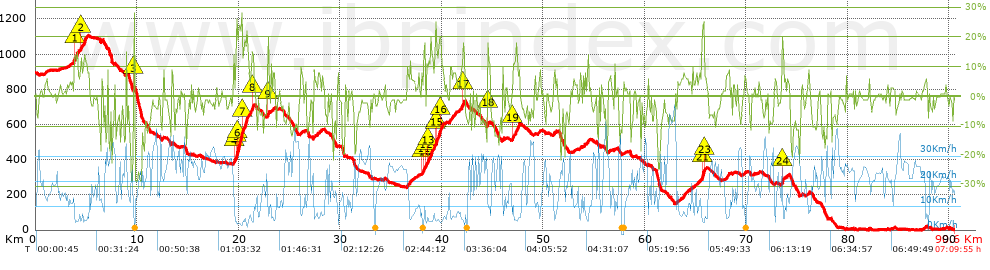
 Total length: 90.61 Km    mi / ft ?
 Analyzed distance: 90.61 Km
 Lineal distance: 57.23 Km
 Accumulated climb: 2197.04 m  info Points list
 Accumulated descent: 3084.04 m
 Maximum height: 1107.2 m
 Minimal height: -0.4 m
 Start height: 893.5 m
 End height : 2.8 m
 Climb rate: 6.62 %
 Descent rate: 7.22 %
 Positive climb difference per Km: 24.25 m
 Negative descent difference per Km: 34.04 m
 Max slope filter: ~30 %
 Min. points separation: ~30 m
 Number of points: 1255   (cad. 72.2 m)
 Significant points: 1159   (cad. 78.25 m / 92.35 %)
 Direction changes per Km: 7.13
 Direction changes >5º per Km: 6.47
 Accumulated straight stretches: 4.061 Km
 Straight stretches per Km: 44.82 m
 Penalizables slope changes: 30
 Penalizables slope changes per Km: 0.331
 Total time: 7:09:55 h
 Time in movement: 6:19:28 h
 Stopped time: 0:50:27 h
 Total speed average: 12.65 Km/h
 Average speed in movement : 14.33 Km/h
 Maximum held speed: 48.99 Km/h
Your fitness level
37


Altitude Slope % Speed Km/h Speed < 2 Km/h

Steep slopes > 5%

Steep slopes >5% Steep slopes >10% Steep slopes >15% Steep slopes >20% Steep slopes >25%
 Steep slope of 1470 m.  Average slope  Interval  Download as waypoint
1
 km 3.794  14%  397 m
2
 km 4.191  7%  275 m
3
 km 4.465  11%  468 m
4
 km 4.934  10%  330 m
 Steep slope of 136 m.  Average slope  Interval  Download as waypoint
5
 km 9.661  22%  136 m
 Steep slope of 1914 m.  Average slope  Interval  Download as waypoint
6
 km 19.511  11%  260 m
7
 km 19.77  16%  53 m
8
 km 19.823  22%  461 m
9
 km 20.284  19%  599 m
10
 km 20.884  9%  310 m
11
 km 21.194  16%  231 m
 Steep slope of 202 m.  Average slope  Interval  Download as waypoint
12
 km 22.843  8%  58 m
13
 km 22.901  19%  144 m
 Steep slope of 145 m.  Average slope  Interval  Download as waypoint
14
 km 23.226  5%  145 m
 Steep slope of 235 m.  Average slope  Interval  Download as waypoint
15
 km 26.15  7%  235 m
 Steep slope of 557 m.  Average slope  Interval  Download as waypoint
16
 km 27.399  6%  557 m
 Steep slope of 479 m.  Average slope  Interval  Download as waypoint
17
 km 36.616  8%  479 m
 Steep slope of 2117 m.  Average slope  Interval  Download as waypoint
18
 km 38.028  9%  34 m
19
 km 38.063  10%  200 m
20
 km 38.262  11%  215 m
21
 km 38.477  12%  199 m
22
 km 38.676  14%  512 m
23
 km 39.188  9%  161 m
24
 km 39.349  14%  83 m
25
 km 39.432  17%  370 m
26
 km 39.802  15%  343 m
 Steep slope of 710 m.  Average slope  Interval  Download as waypoint
27
 km 40.787  8%  710 m
 Steep slope of 490 m.  Average slope  Interval  Download as waypoint
28
 km 41.84  7%  130 m
29
 km 41.97  13%  312 m
30
 km 42.282  6%  48 m
 Steep slope of 184 m.  Average slope  Interval  Download as waypoint
31
 km 44.502  12%  184 m
 Steep slope of 774 m.  Average slope  Interval  Download as waypoint
32
 km 46.97  12%  558 m
33
 km 47.528  10%  216 m
 Steep slope of 267 m.  Average slope  Interval  Download as waypoint
34
 km 51.015  6%  267 m
 Steep slope of 319 m.  Average slope  Interval  Download as waypoint
35
 km 54.132  8%  319 m
 Steep slope of 821 m.  Average slope  Interval  Download as waypoint
36
 km 63.598  6%  821 m
 Steep slope of 437 m.  Average slope  Interval  Download as waypoint
37
 km 65.041  6%  437 m
 Steep slope of 270 m.  Average slope  Interval  Download as waypoint
38
 km 65.64  18%  52 m
39
 km 65.692  24%  94 m
40
 km 65.785  25%  78 m
41
 km 65.863  18%  46 m
 Steep slope of 347 m.  Average slope  Interval  Download as waypoint
42
 km 67.995  7%  347 m
 Steep slope of 248 m.  Average slope  Interval  Download as waypoint
43
 km 73.524  17%  153 m
44
 km 73.677  7%  95 m
 Steep slope of 119 m.  Average slope  Interval  Download as waypoint
45
 km 73.98  6%  119 m


Compare this trail with...
Select trails to compare from "My trails". 
demo_montnegrebtt_2013.trk Ref.: 36172170671632
demo_matagalls_montserrat.trk Ref.: 36172170846048
demo_marathon_madrid_2013.trk Ref.: 36172170699197
Compare


Download (Registered users)

  GPX (.gpx)
  Garmin Training Center (.tcx)
  CompeGPS (.trk)
  OziExplorer (.plt)
  Google Earth (.kml)
  PDF analysis


Remove track and analysis
Save this trail on "My trails"


Send this analysis to a friend (Registered users)
Message that will receive your friend:
Re:
Hi.
(your name) has considered that this analysis of a trail could be of your interest.

(he/she will see a link to this page)
E-mail of your friend
You can enter multiple addresses separated by commas
Text
 
Send to a friend