User: Password:   Login   Login with Facebook   Register

Send to a friend
   

Detailed analysis of the trail analyzed as Bicycle (BYC)
Trail difficulty
1346
BYC
Track : transpyr-2019-completa.gpx
These speeds are average for : BYC (Bicycle)
Reanalyze as
HKG (Hiking) RNG (Running)
 Penalty trail's conditions: 57 %   ( > 50 % = MTB, < 50 % = RDB)
 Reliability of the original trail: A   (19008/73/0/-/-/73)
 Level of correction applied to the trail: 0
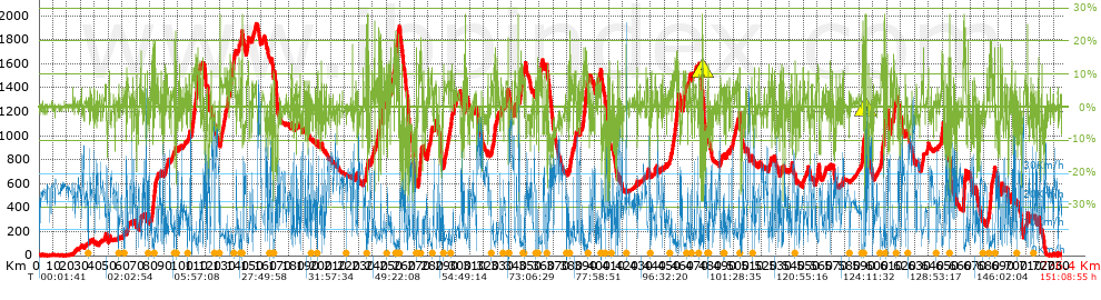
 Total length: 736.33 Km    mi / ft ?
 Analyzed distance: 736.33 Km
 Lineal distance: 424.7 Km
 Accumulated climb: 18913.77 m  info Points list
 Accumulated descent: 18927.34 m
 Maximum height: 1930.7 m
 Minimal height: -0.4 m
 Start height: 1.8 m
 End height : 2.8 m
 Climb rate: 6.13 %
 Descent rate: 6.54 %
 Positive climb difference per Km: 25.69 m
 Negative descent difference per Km: 25.7 m
 Max slope filter: ~30 %
 Min. points separation: ~30 m
 Number of points: 9660   (cad. 76.23 m)
 Significant points: 8711   (cad. 84.57 m / 90.18 %)
 Direction changes per Km: 6.44
 Direction changes >5º per Km: 5.84
 Accumulated straight stretches: 45.941 Km
 Straight stretches per Km: 62.39 m
 Penalizables slope changes: 177
 Penalizables slope changes per Km: 0.24
 Total time: 151:08:55 h
 Time in movement: 53:07:55 h
 Stopped time: 98:01:00 h
 Total speed average: 4.87 Km/h
 Average speed in movement : 13.86 Km/h
 Maximum held speed: 63.44 Km/h
Your fitness level
?*
* fit = ? Not enought comparison elements or invalid track


Altitude Slope % Speed Km/h Speed < 2 Km/h

Steep slopes > 10%

Steep slopes >5% Steep slopes >10% Steep slopes >15% Steep slopes >20% Steep slopes >25%
 Steep slope of 1597 m.  Average slope  Interval  Download as waypoint
1
 km 81.684  10%  333 m
2
 km 82.017  14%  69 m
3
 km 82.086  13%  76 m
4
 km 82.162  19%  78 m
5
 km 82.24  14%  411 m
6
 km 83.216  11%  439 m
7
 km 83.655  19%  118 m
8
 km 83.773  23%  73 m
 Steep slope of 271 m.  Average slope  Interval  Download as waypoint
9
 km 87.835  11%  271 m
 Steep slope of 222 m.  Average slope  Interval  Download as waypoint
10
 km 98.294  11%  222 m
 Steep slope of 1387 m.  Average slope  Interval  Download as waypoint
11
 km 110.311  12%  313 m
12
 km 111.478  11%  445 m
13
 km 112.328  12%  629 m
 Steep slope of 1306 m.  Average slope  Interval  Download as waypoint
14
 km 113.158  12%  1108 m
15
 km 115.999  13%  198 m
 Steep slope of 183 m.  Average slope  Interval  Download as waypoint
16
 km 117.714  13%  183 m
 Steep slope of 1572 m.  Average slope  Interval  Download as waypoint
17
 km 135.995  13%  124 m
18
 km 137.271  12%  552 m
19
 km 138.265  12%  243 m
20
 km 140.055  13%  653 m
 Steep slope of 259 m.  Average slope  Interval  Download as waypoint
21
 km 143.931  14%  259 m
 Steep slope of 666 m.  Average slope  Interval  Download as waypoint
22
 km 145.7  11%  467 m
23
 km 146.166  28%  77 m
24
 km 146.243  24%  122 m
 Steep slope of 235 m.  Average slope  Interval  Download as waypoint
25
 km 235.288  14%  235 m
 Steep slope of 226 m.  Average slope  Interval  Download as waypoint
26
 km 235.723  11%  52 m
27
 km 235.776  19%  174 m
 Steep slope of 84 m.  Average slope  Interval  Download as waypoint
28
 km 236.264  13%  84 m
 Steep slope of 89 m.  Average slope  Interval  Download as waypoint
29
 km 236.51  28%  89 m
 Steep slope of 202 m.  Average slope  Interval  Download as waypoint
30
 km 236.773  20%  202 m
 Steep slope of 37 m.  Average slope  Interval  Download as waypoint
31
 km 237.413  20%  37 m
 Steep slope of 182 m.  Average slope  Interval  Download as waypoint
32
 km 237.715  13%  45 m
33
 km 237.76  13%  137 m
 Steep slope of 129 m.  Average slope  Interval  Download as waypoint
34
 km 244.404  24%  129 m
 Steep slope of 378 m.  Average slope  Interval  Download as waypoint
35
 km 245.243  14%  275 m
36
 km 245.518  18%  103 m
 Steep slope of 144 m.  Average slope  Interval  Download as waypoint
37
 km 246.229  16%  144 m
 Steep slope of 363 m.  Average slope  Interval  Download as waypoint
38
 km 255.291  14%  363 m
 Steep slope of 1784 m.  Average slope  Interval  Download as waypoint
39
 km 256.041  13%  301 m
40
 km 256.509  15%  360 m
41
 km 256.868  11%  401 m
42
 km 258.251  13%  287 m
43
 km 258.538  17%  324 m
44
 km 258.861  10%  111 m
 Steep slope of 1970 m.  Average slope  Interval  Download as waypoint
45
 km 273.362  11%  721 m
46
 km 274.082  16%  320 m
47
 km 274.402  15%  245 m
48
 km 274.647  13%  169 m
49
 km 274.866  15%  65 m
50
 km 274.931  16%  267 m
51
 km 275.198  12%  183 m
 Steep slope of 479 m.  Average slope  Interval  Download as waypoint
52
 km 280.1  13%  207 m
53
 km 282.589  10%  272 m
 Steep slope of 311 m.  Average slope  Interval  Download as waypoint
54
 km 296.582  11%  311 m
 Steep slope of 143 m.  Average slope  Interval  Download as waypoint
55
 km 306.711  12%  143 m
 Steep slope of 258 m.  Average slope  Interval  Download as waypoint
56
 km 307.62  11%  258 m
 Steep slope of 1267 m.  Average slope  Interval  Download as waypoint
57
 km 327.227  11%  596 m
58
 km 327.824  10%  414 m
59
 km 328.238  17%  257 m
 Steep slope of 294 m.  Average slope  Interval  Download as waypoint
60
 km 329.745  11%  294 m
 Steep slope of 339 m.  Average slope  Interval  Download as waypoint
61
 km 342.45  10%  339 m
 Steep slope of 252 m.  Average slope  Interval  Download as waypoint
62
 km 344.768  25%  190 m
63
 km 344.958  11%  62 m
 Steep slope of 1251 m.  Average slope  Interval  Download as waypoint
64
 km 346.827  11%  335 m
65
 km 347.162  10%  560 m
66
 km 347.722  12%  356 m
 Steep slope of 840 m.  Average slope  Interval  Download as waypoint
67
 km 358.772  12%  259 m
68
 km 359.452  12%  207 m
69
 km 360.525  10%  155 m
70
 km 361.033  10%  219 m
 Steep slope of 176 m.  Average slope  Interval  Download as waypoint
71
 km 381.13  10%  176 m
 Steep slope of 556 m.  Average slope  Interval  Download as waypoint
72
 km 382.024  10%  309 m
73
 km 385.811  10%  247 m
 Steep slope of 2633 m.  Average slope  Interval  Download as waypoint
74
 km 391.976  11%  135 m
75
 km 392.111  16%  116 m
76
 km 392.227  13%  157 m
77
 km 392.678  12%  613 m
78
 km 393.291  15%  234 m
79
 km 393.525  13%  302 m
80
 km 393.827  10%  318 m
81
 km 394.145  11%  402 m
82
 km 394.547  10%  193 m
83
 km 394.741  11%  163 m
 Steep slope of 163 m.  Average slope  Interval  Download as waypoint
84
 km 401.56  10%  163 m
 Steep slope of 282 m.  Average slope  Interval  Download as waypoint
85
 km 416.353  10%  282 m
 Steep slope of 190 m.  Average slope  Interval  Download as waypoint
86
 km 440.687  11%  190 m
 Steep slope of 1724 m.  Average slope  Interval  Download as waypoint
87
 km 457.605  12%  262 m
88
 km 458.4  14%  405 m
89
 km 459.086  17%  245 m
90
 km 459.331  12%  242 m
91
 km 459.803  13%  288 m
92
 km 460.276  10%  282 m
 Steep slope of 452 m.  Average slope  Interval  Download as waypoint
93
 km 463.911  11%  300 m
94
 km 465.505  11%  152 m
 Steep slope of 196 m.  Average slope  Interval  Download as waypoint
95
 km 477.477  28%  159 m
96
 km 477.636  16%  37 m
 Steep slope of 194 m.  Average slope  Interval  Download as waypoint
97
 km 504.243  10%  194 m
 Steep slope of 249 m.  Average slope  Interval  Download as waypoint
98
 km 518.071  12%  249 m
 Steep slope of 166 m.  Average slope  Interval  Download as waypoint
99
 km 535.817  12%  166 m
 Steep slope of 335 m.  Average slope  Interval  Download as waypoint
100
 km 549.85  11%  335 m
 Steep slope of 380 m.  Average slope  Interval  Download as waypoint
101
 km 560.521  11%  380 m
 Steep slope of 972 m.  Average slope  Interval  Download as waypoint
102
 km 592.625  11%  97 m
103
 km 592.722  17%  135 m
104
 km 592.857  19%  292 m
105
 km 593.149  18%  363 m
106
 km 593.512  14%  85 m
 Steep slope of 479 m.  Average slope  Interval  Download as waypoint
107
 km 594.398  11%  117 m
108
 km 594.515  26%  107 m
109
 km 594.77  28%  185 m
110
 km 594.955  28%  70 m
 Steep slope of 776 m.  Average slope  Interval  Download as waypoint
111
 km 606.275  13%  776 m
 Steep slope of 949 m.  Average slope  Interval  Download as waypoint
112
 km 608.156  22%  439 m
113
 km 608.595  15%  173 m
114
 km 608.768  20%  58 m
115
 km 608.935  17%  173 m
116
 km 609.108  14%  106 m
 Steep slope of 524 m.  Average slope  Interval  Download as waypoint
117
 km 610.254  13%  524 m
 Steep slope of 441 m.  Average slope  Interval  Download as waypoint
118
 km 612.933  10%  166 m
119
 km 613.344  12%  275 m
 Steep slope of 874 m.  Average slope  Interval  Download as waypoint
120
 km 615.002  13%  550 m
121
 km 615.747  11%  324 m
 Steep slope of 865 m.  Average slope  Interval  Download as waypoint
122
 km 649.52  14%  397 m
123
 km 650.191  11%  468 m
 Steep slope of 136 m.  Average slope  Interval  Download as waypoint
124
 km 655.387  22%  136 m
 Steep slope of 1653 m.  Average slope  Interval  Download as waypoint
125
 km 665.236  11%  260 m
126
 km 665.496  16%  53 m
127
 km 665.549  22%  461 m
128
 km 666.01  19%  599 m
129
 km 666.92  16%  280 m
 Steep slope of 144 m.  Average slope  Interval  Download as waypoint
130
 km 668.627  19%  144 m
 Steep slope of 2234 m.  Average slope  Interval  Download as waypoint
131
 km 683.789  10%  200 m
132
 km 683.988  11%  215 m
133
 km 684.203  12%  199 m
134
 km 684.402  14%  512 m
135
 km 685.075  14%  83 m
136
 km 685.158  17%  370 m
137
 km 685.528  15%  343 m
138
 km 687.696  13%  312 m
 Steep slope of 184 m.  Average slope  Interval  Download as waypoint
139
 km 690.227  12%  184 m
 Steep slope of 558 m.  Average slope  Interval  Download as waypoint
140
 km 692.696  12%  558 m
 Steep slope of 270 m.  Average slope  Interval  Download as waypoint
141
 km 711.366  18%  52 m
142
 km 711.418  24%  94 m
143
 km 711.511  25%  78 m
144
 km 711.589  18%  46 m
 Steep slope of 153 m.  Average slope  Interval  Download as waypoint
145
 km 719.25  17%  153 m


Compare this trail with...
Select trails to compare from "My trails". 
demo_montnegrebtt_2013.trk Ref.: 36172170671632
demo_matagalls_montserrat.trk Ref.: 36172170846048
demo_marathon_madrid_2013.trk Ref.: 36172170699197
Compare


Download (Registered users)

  GPX (.gpx)
  Garmin Training Center (.tcx)
  CompeGPS (.trk)
  OziExplorer (.plt)
  Google Earth (.kml)
  PDF analysis


Remove track and analysis
Save this trail on "My trails"


Send this analysis to a friend (Registered users)
Message that will receive your friend:
Re:
Hi.
(your name) has considered that this analysis of a trail could be of your interest.

(he/she will see a link to this page)
E-mail of your friend
You can enter multiple addresses separated by commas
Text
 
Send to a friend