User: Password:   Login   Login with Facebook   Register

Send to a friend
   

Detailed analysis of the trail analyzed as Running (RNG)
Trail difficulty
3985
RNG
Track : transpyr-2019-completa.gpx
These speeds are average for : BYC (Bicycle)
Reanalyze as
BYC (Bicycle) HKG (Hiking)
 Reliability of the original trail: A   (19008/73/0/-/-/73)
 Level of correction applied to the trail: 0
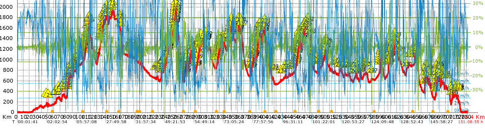
 Total length: 736.44 Km    mi / ft ?
 Analyzed distance: 736.44 Km
 Lineal distance: 424.7 Km
 Accumulated climb: 19018.28 m  info Points list
 Accumulated descent: 19032.18 m
 Maximum height: 1930.7 m
 Minimal height: -0.4 m
 Start height: 1.8 m
 End height : 2.8 m
 Climb rate: 6.16 %
 Descent rate: 6.59 %
 Positive climb difference per Km: 25.82 m
 Negative descent difference per Km: 25.84 m
 Max slope filter: ~55 %
 Min. points separation: ~30 m
 Number of points: 9660   (cad. 76.24 m)
 Significant points: 8711   (cad. 84.55 m / 90.18 %)
 Direction changes per Km: 6.44
 Direction changes >5º per Km: 5.84
 Accumulated straight stretches: 45.976 Km
 Straight stretches per Km: 62.43 m
 Penalizables slope changes: 177
 Penalizables slope changes per Km: 0.24
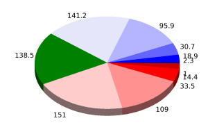
 Total time: 151:08:55 h
 Time in movement: 55:04:08 h
 Stopped time: 96:04:47 h
 Total speed average: 4.87 Km/h
 Average speed in movement : 13.37 Km/h
 Maximum held speed: 63.44 Km/h


Altitude Slope % Speed Km/h Speed < 0.5 Km/h

Steep slopes > 5%

Steep slopes >5% Steep slopes >10% Steep slopes >15% Steep slopes >20% Steep slopes >25%
 Steep slope of 334 m.  Average slope  Interval  Download as waypoint
1
 km 47.54  5%  334 m
 Steep slope of 492 m.  Average slope  Interval  Download as waypoint
2
 km 50.462  8%  492 m
 Steep slope of 122 m.  Average slope  Interval  Download as waypoint
3
 km 61.399  7%  122 m
 Steep slope of 203 m.  Average slope  Interval  Download as waypoint
4
 km 62.973  9%  203 m
 Steep slope of 956 m.  Average slope  Interval  Download as waypoint
5
 km 63.499  7%  956 m
 Steep slope of 269 m.  Average slope  Interval  Download as waypoint
6
 km 67.397  6%  269 m
 Steep slope of 161 m.  Average slope  Interval  Download as waypoint
7
 km 70.276  8%  161 m
 Steep slope of 602 m.  Average slope  Interval  Download as waypoint
8
 km 72.605  7%  602 m
 Steep slope of 460 m.  Average slope  Interval  Download as waypoint
9
 km 73.388  11%  460 m
 Steep slope of 284 m.  Average slope  Interval  Download as waypoint
10
 km 76.19  9%  284 m
 Steep slope of 158 m.  Average slope  Interval  Download as waypoint
11
 km 77.857  9%  158 m
 Steep slope of 204 m.  Average slope  Interval  Download as waypoint
12
 km 80.984  12%  204 m
 Steep slope of 444 m.  Average slope  Interval  Download as waypoint
13
 km 81.402  6%  282 m
14
 km 81.685  16%  162 m
 Steep slope of 845 m.  Average slope  Interval  Download as waypoint
15
 km 82.017  14%  69 m
16
 km 82.086  13%  76 m
17
 km 82.162  19%  78 m
18
 km 82.24  14%  411 m
19
 km 82.651  11%  211 m
 Steep slope of 727 m.  Average slope  Interval  Download as waypoint
20
 km 83.119  8%  97 m
21
 km 83.216  11%  439 m
22
 km 83.655  19%  118 m
23
 km 83.773  23%  73 m
 Steep slope of 171 m.  Average slope  Interval  Download as waypoint
24
 km 84.714  8%  171 m
 Steep slope of 379 m.  Average slope  Interval  Download as waypoint
25
 km 87.777  6%  58 m
26
 km 87.835  11%  271 m
27
 km 88.107  9%  50 m
 Steep slope of 433 m.  Average slope  Interval  Download as waypoint
28
 km 91.218  8%  433 m
 Steep slope of 217 m.  Average slope  Interval  Download as waypoint
29
 km 92.218  6%  217 m
 Steep slope of 165 m.  Average slope  Interval  Download as waypoint
30
 km 96.566  5%  165 m
 Steep slope of 46 m.  Average slope  Interval  Download as waypoint
31
 km 97.678  12%  46 m
 Steep slope of 302 m.  Average slope  Interval  Download as waypoint
32
 km 98.076  5%  218 m
33
 km 98.294  23%  84 m
 Steep slope of 132 m.  Average slope  Interval  Download as waypoint
34
 km 98.515  11%  132 m
 Steep slope of 162 m.  Average slope  Interval  Download as waypoint
35
 km 101.063  11%  162 m
 Steep slope of 722 m.  Average slope  Interval  Download as waypoint
36
 km 107.869  8%  722 m
 Steep slope of 3161 m.  Average slope  Interval  Download as waypoint
37
 km 109.854  7%  457 m
38
 km 110.311  12%  313 m
39
 km 110.624  9%  854 m
40
 km 111.478  11%  445 m
41
 km 111.923  7%  406 m
42
 km 112.329  12%  629 m
43
 km 112.958  9%  57 m
 Steep slope of 2102 m.  Average slope  Interval  Download as waypoint
44
 km 113.159  12%  1108 m
45
 km 114.267  10%  994 m
 Steep slope of 61 m.  Average slope  Interval  Download as waypoint
46
 km 116  11%  61 m
 Steep slope of 423 m.  Average slope  Interval  Download as waypoint
47
 km 117.659  9%  55 m
48
 km 117.715  13%  183 m
49
 km 117.898  7%  185 m
 Steep slope of 4152 m.  Average slope  Interval  Download as waypoint
50
 km 130.467  7%  4152 m
 Steep slope of 768 m.  Average slope  Interval  Download as waypoint
51
 km 135.318  7%  678 m
52
 km 135.996  11%  90 m
 Steep slope of 426 m.  Average slope  Interval  Download as waypoint
53
 km 136.379  5%  426 m
 Steep slope of 3748 m.  Average slope  Interval  Download as waypoint
54
 km 137.111  8%  160 m
55
 km 137.272  12%  552 m
56
 km 137.823  8%  443 m
57
 km 138.266  12%  243 m
58
 km 138.509  5%  478 m
59
 km 138.987  8%  1069 m
60
 km 140.056  13%  653 m
61
 km 140.709  6%  150 m
 Steep slope of 320 m.  Average slope  Interval  Download as waypoint
62
 km 141.203  8%  320 m
 Steep slope of 259 m.  Average slope  Interval  Download as waypoint
63
 km 143.932  14%  259 m
 Steep slope of 174 m.  Average slope  Interval  Download as waypoint
64
 km 144.655  5%  174 m
 Steep slope of 719 m.  Average slope  Interval  Download as waypoint
65
 km 145.614  8%  86 m
66
 km 145.701  11%  467 m
67
 km 146.167  29%  166 m
 Steep slope of 1794 m.  Average slope  Interval  Download as waypoint
68
 km 149.219  8%  1794 m
 Steep slope of 456 m.  Average slope  Interval  Download as waypoint
69
 km 153.255  7%  456 m
 Steep slope of 213 m.  Average slope  Interval  Download as waypoint
70
 km 154.241  7%  213 m
 Steep slope of 549 m.  Average slope  Interval  Download as waypoint
71
 km 155.459  5%  549 m
 Steep slope of 352 m.  Average slope  Interval  Download as waypoint
72
 km 167.005  6%  352 m
 Steep slope of 687 m.  Average slope  Interval  Download as waypoint
73
 km 168.697  8%  687 m
 Steep slope of 149 m.  Average slope  Interval  Download as waypoint
74
 km 181.429  8%  149 m
 Steep slope of 315 m.  Average slope  Interval  Download as waypoint
75
 km 182  9%  315 m
 Steep slope of 392 m.  Average slope  Interval  Download as waypoint
76
 km 184.4  6%  392 m
 Steep slope of 476 m.  Average slope  Interval  Download as waypoint
77
 km 185.376  6%  476 m
 Steep slope of 219 m.  Average slope  Interval  Download as waypoint
78
 km 187.876  8%  219 m
 Steep slope of 193 m.  Average slope  Interval  Download as waypoint
79
 km 191.953  7%  193 m
 Steep slope of 269 m.  Average slope  Interval  Download as waypoint
80
 km 192.869  7%  269 m
 Steep slope of 346 m.  Average slope  Interval  Download as waypoint
81
 km 200.454  9%  346 m
 Steep slope of 240 m.  Average slope  Interval  Download as waypoint
82
 km 203.193  7%  240 m
 Steep slope of 184 m.  Average slope  Interval  Download as waypoint
83
 km 225.584  10%  184 m
 Steep slope of 509 m.  Average slope  Interval  Download as waypoint
84
 km 227.838  7%  509 m
 Steep slope of 225 m.  Average slope  Interval  Download as waypoint
85
 km 233.174  6%  225 m
 Steep slope of 305 m.  Average slope  Interval  Download as waypoint
86
 km 235.235  6%  70 m
87
 km 235.305  14%  235 m
 Steep slope of 148 m.  Average slope  Interval  Download as waypoint
88
 km 235.741  11%  52 m
89
 km 235.793  22%  96 m
 Steep slope of 184 m.  Average slope  Interval  Download as waypoint
90
 km 236.097  8%  184 m
 Steep slope of 470 m.  Average slope  Interval  Download as waypoint
91
 km 236.527  5%  267 m
92
 km 236.794  21%  203 m
 Steep slope of 37 m.  Average slope  Interval  Download as waypoint
93
 km 237.436  20%  37 m
 Steep slope of 182 m.  Average slope  Interval  Download as waypoint
94
 km 237.738  13%  45 m
95
 km 237.783  13%  137 m
 Steep slope of 646 m.  Average slope  Interval  Download as waypoint
96
 km 239.591  8%  646 m
 Steep slope of 382 m.  Average slope  Interval  Download as waypoint
97
 km 242.318  5%  382 m
 Steep slope of 207 m.  Average slope  Interval  Download as waypoint
98
 km 243.03  8%  207 m
 Steep slope of 784 m.  Average slope  Interval  Download as waypoint
99
 km 243.776  7%  655 m
100
 km 244.431  24%  129 m
 Steep slope of 1097 m.  Average slope  Interval  Download as waypoint
101
 km 244.653  5%  619 m
102
 km 245.272  22%  169 m
103
 km 245.441  10%  209 m
104
 km 245.65  12%  100 m
 Steep slope of 881 m.  Average slope  Interval  Download as waypoint
105
 km 246.259  16%  144 m
106
 km 246.403  6%  331 m
107
 km 246.734  10%  406 m
 Steep slope of 187 m.  Average slope  Interval  Download as waypoint
108
 km 248.435  10%  187 m
 Steep slope of 298 m.  Average slope  Interval  Download as waypoint
109
 km 249.059  6%  298 m
 Steep slope of 297 m.  Average slope  Interval  Download as waypoint
110
 km 249.71  10%  297 m
 Steep slope of 346 m.  Average slope  Interval  Download as waypoint
111
 km 250.309  5%  346 m
 Steep slope of 413 m.  Average slope  Interval  Download as waypoint
112
 km 251.522  5%  413 m
 Steep slope of 316 m.  Average slope  Interval  Download as waypoint
113
 km 252.356  8%  316 m
 Steep slope of 533 m.  Average slope  Interval  Download as waypoint
114
 km 253.134  10%  533 m
 Steep slope of 379 m.  Average slope  Interval  Download as waypoint
115
 km 254.04  6%  379 m
 Steep slope of 917 m.  Average slope  Interval  Download as waypoint
116
 km 254.727  7%  594 m
117
 km 255.322  14%  323 m
 Steep slope of 1714 m.  Average slope  Interval  Download as waypoint
118
 km 255.859  8%  212 m
119
 km 256.071  13%  301 m
120
 km 256.372  8%  167 m
121
 km 256.539  15%  360 m
122
 km 256.899  11%  401 m
123
 km 257.3  5%  273 m
 Steep slope of 208 m.  Average slope  Interval  Download as waypoint
124
 km 257.816  9%  208 m
 Steep slope of 722 m.  Average slope  Interval  Download as waypoint
125
 km 258.281  13%  287 m
126
 km 258.568  17%  324 m
127
 km 258.891  10%  111 m
 Steep slope of 2497 m.  Average slope  Interval  Download as waypoint
128
 km 273.12  9%  275 m
129
 km 273.395  11%  721 m
130
 km 274.116  16%  320 m
131
 km 274.436  15%  245 m
132
 km 274.68  13%  169 m
133
 km 274.85  9%  49 m
134
 km 274.899  15%  65 m
135
 km 274.965  16%  267 m
136
 km 275.232  12%  183 m
137
 km 275.415  11%  203 m
 Steep slope of 724 m.  Average slope  Interval  Download as waypoint
138
 km 279.617  9%  517 m
139
 km 280.134  13%  207 m
 Steep slope of 396 m.  Average slope  Interval  Download as waypoint
140
 km 280.548  6%  396 m
 Steep slope of 1160 m.  Average slope  Interval  Download as waypoint
141
 km 281.821  8%  802 m
142
 km 282.623  10%  272 m
143
 km 282.895  6%  86 m
 Steep slope of 688 m.  Average slope  Interval  Download as waypoint
144
 km 284.71  6%  688 m
 Steep slope of 306 m.  Average slope  Interval  Download as waypoint
145
 km 285.848  7%  306 m
 Steep slope of 1751 m.  Average slope  Interval  Download as waypoint
146
 km 291.182  5%  134 m
147
 km 291.315  14%  51 m
148
 km 291.367  6%  1566 m
 Steep slope of 1271 m.  Average slope  Interval  Download as waypoint
149
 km 293.45  7%  1271 m
 Steep slope of 1265 m.  Average slope  Interval  Download as waypoint
150
 km 294.897  7%  1265 m
 Steep slope of 1005 m.  Average slope  Interval  Download as waypoint
151
 km 296.462  7%  154 m
152
 km 296.616  11%  311 m
153
 km 296.927  10%  540 m
 Steep slope of 599 m.  Average slope  Interval  Download as waypoint
154
 km 298.435  9%  599 m
 Steep slope of 402 m.  Average slope  Interval  Download as waypoint
155
 km 300.084  6%  402 m
 Steep slope of 206 m.  Average slope  Interval  Download as waypoint
156
 km 306.746  12%  144 m
157
 km 306.889  15%  62 m
 Steep slope of 541 m.  Average slope  Interval  Download as waypoint
158
 km 307.325  6%  331 m
159
 km 307.656  12%  210 m
 Steep slope of 249 m.  Average slope  Interval  Download as waypoint
160
 km 308.278  5%  249 m
 Steep slope of 316 m.  Average slope  Interval  Download as waypoint
161
 km 323.103  9%  316 m
 Steep slope of 681 m.  Average slope  Interval  Download as waypoint
162
 km 325.477  5%  681 m
 Steep slope of 222 m.  Average slope  Interval  Download as waypoint
163
 km 326.487  7%  222 m
 Steep slope of 1204 m.  Average slope  Interval  Download as waypoint
164
 km 327.263  11%  596 m
165
 km 327.859  10%  414 m
166
 km 328.273  16%  194 m
 Steep slope of 213 m.  Average slope  Interval  Download as waypoint
167
 km 329.25  8%  213 m
 Steep slope of 294 m.  Average slope  Interval  Download as waypoint
168
 km 329.78  11%  294 m
 Steep slope of 757 m.  Average slope  Interval  Download as waypoint
169
 km 332.301  7%  757 m
 Steep slope of 1686 m.  Average slope  Interval  Download as waypoint
170
 km 335.986  8%  1686 m
 Steep slope of 1053 m.  Average slope  Interval  Download as waypoint
171
 km 342.217  6%  269 m
172
 km 342.486  10%  339 m
173
 km 342.825  8%  445 m
 Steep slope of 490 m.  Average slope  Interval  Download as waypoint
174
 km 344.567  7%  236 m
175
 km 344.803  25%  192 m
176
 km 344.995  9%  62 m
 Steep slope of 1359 m.  Average slope  Interval  Download as waypoint
177
 km 345.973  8%  891 m
178
 km 346.865  11%  335 m
179
 km 347.199  12%  133 m
 Steep slope of 1460 m.  Average slope  Interval  Download as waypoint
180
 km 347.561  10%  198 m
181
 km 347.759  12%  356 m
182
 km 348.116  8%  906 m
 Steep slope of 605 m.  Average slope  Interval  Download as waypoint
183
 km 349.757  8%  605 m
 Steep slope of 587 m.  Average slope  Interval  Download as waypoint
184
 km 357.144  6%  587 m
 Steep slope of 172 m.  Average slope  Interval  Download as waypoint
185
 km 358.81  12%  172 m
 Steep slope of 294 m.  Average slope  Interval  Download as waypoint
186
 km 359.069  5%  120 m
187
 km 359.189  8%  174 m
 Steep slope of 245 m.  Average slope  Interval  Download as waypoint
188
 km 359.489  12%  207 m
189
 km 359.696  11%  38 m
 Steep slope of 1526 m.  Average slope  Interval  Download as waypoint
190
 km 359.911  8%  651 m
191
 km 360.563  10%  155 m
192
 km 360.718  8%  353 m
193
 km 361.07  10%  219 m
194
 km 361.289  9%  148 m
 Steep slope of 767 m.  Average slope  Interval  Download as waypoint
195
 km 361.607  8%  767 m
 Steep slope of 357 m.  Average slope  Interval  Download as waypoint
196
 km 363.928  10%  357 m
 Steep slope of 195 m.  Average slope  Interval  Download as waypoint
197
 km 366.233  5%  195 m
 Steep slope of 507 m.  Average slope  Interval  Download as waypoint
198
 km 380.837  6%  331 m
199
 km 381.168  10%  176 m
 Steep slope of 768 m.  Average slope  Interval  Download as waypoint
200
 km 382.063  10%  309 m
201
 km 382.372  11%  459 m
 Steep slope of 788 m.  Average slope  Interval  Download as waypoint
202
 km 383.254  6%  788 m
 Steep slope of 258 m.  Average slope  Interval  Download as waypoint
203
 km 384.349  7%  258 m
 Steep slope of 484 m.  Average slope  Interval  Download as waypoint
204
 km 385.144  8%  484 m
 Steep slope of 1086 m.  Average slope  Interval  Download as waypoint
205
 km 385.786  10%  63 m
206
 km 385.85  10%  247 m
207
 km 386.096  9%  776 m
 Steep slope of 354 m.  Average slope  Interval  Download as waypoint
208
 km 388.28  7%  354 m
 Steep slope of 360 m.  Average slope  Interval  Download as waypoint
209
 km 389.611  7%  360 m
 Steep slope of 395 m.  Average slope  Interval  Download as waypoint
210
 km 391.23  7%  395 m
 Steep slope of 3047 m.  Average slope  Interval  Download as waypoint
211
 km 391.933  9%  82 m
212
 km 392.015  11%  135 m
213
 km 392.149  16%  116 m
214
 km 392.265  13%  157 m
215
 km 392.422  7%  295 m
216
 km 392.717  12%  613 m
217
 km 393.329  15%  234 m
218
 km 393.563  13%  302 m
219
 km 393.865  10%  318 m
220
 km 394.184  11%  402 m
221
 km 394.586  10%  193 m
222
 km 394.779  11%  163 m
223
 km 394.943  15%  37 m
 Steep slope of 225 m.  Average slope  Interval  Download as waypoint
224
 km 395.257  5%  225 m
 Steep slope of 340 m.  Average slope  Interval  Download as waypoint
225
 km 396.878  7%  340 m
 Steep slope of 360 m.  Average slope  Interval  Download as waypoint
226
 km 400.876  7%  360 m
 Steep slope of 601 m.  Average slope  Interval  Download as waypoint
227
 km 401.506  8%  93 m
228
 km 401.599  10%  163 m
229
 km 401.762  7%  345 m
 Steep slope of 854 m.  Average slope  Interval  Download as waypoint
230
 km 402.833  6%  854 m
 Steep slope of 271 m.  Average slope  Interval  Download as waypoint
231
 km 404.345  6%  271 m
 Steep slope of 383 m.  Average slope  Interval  Download as waypoint
232
 km 416.394  10%  282 m
233
 km 416.676  12%  101 m
 Steep slope of 271 m.  Average slope  Interval  Download as waypoint
234
 km 430.262  8%  271 m
 Steep slope of 502 m.  Average slope  Interval  Download as waypoint
235
 km 437.933  8%  502 m
 Steep slope of 190 m.  Average slope  Interval  Download as waypoint
236
 km 440.729  11%  190 m
 Steep slope of 641 m.  Average slope  Interval  Download as waypoint
237
 km 443.221  8%  641 m
 Steep slope of 291 m.  Average slope  Interval  Download as waypoint
238
 km 448.677  8%  291 m
 Steep slope of 313 m.  Average slope  Interval  Download as waypoint
239
 km 453.82  6%  313 m
 Steep slope of 553 m.  Average slope  Interval  Download as waypoint
240
 km 454.674  7%  553 m
 Steep slope of 1292 m.  Average slope  Interval  Download as waypoint
241
 km 455.655  8%  1292 m
 Steep slope of 1678 m.  Average slope  Interval  Download as waypoint
242
 km 457.169  7%  479 m
243
 km 457.648  12%  262 m
244
 km 457.91  9%  532 m
245
 km 458.443  14%  405 m
 Steep slope of 1708 m.  Average slope  Interval  Download as waypoint
246
 km 459.072  10%  57 m
247
 km 459.129  17%  245 m
248
 km 459.374  12%  242 m
249
 km 459.615  8%  230 m
250
 km 459.845  13%  288 m
251
 km 460.133  9%  185 m
252
 km 460.318  10%  282 m
253
 km 460.601  8%  179 m
 Steep slope of 2267 m.  Average slope  Interval  Download as waypoint
254
 km 463.434  7%  520 m
255
 km 463.953  11%  300 m
256
 km 464.253  8%  1295 m
257
 km 465.548  11%  152 m
 Steep slope of 360 m.  Average slope  Interval  Download as waypoint
258
 km 467.306  7%  360 m
 Steep slope of 719 m.  Average slope  Interval  Download as waypoint
259
 km 468.361  6%  719 m
 Steep slope of 421 m.  Average slope  Interval  Download as waypoint
260
 km 470.529  7%  421 m
 Steep slope of 1009 m.  Average slope  Interval  Download as waypoint
261
 km 472.099  6%  1009 m
 Steep slope of 509 m.  Average slope  Interval  Download as waypoint
262
 km 474.85  7%  509 m
 Steep slope of 163 m.  Average slope  Interval  Download as waypoint
263
 km 477.54  34%  163 m
 Steep slope of 218 m.  Average slope  Interval  Download as waypoint
264
 km 481.06  7%  218 m
 Steep slope of 144 m.  Average slope  Interval  Download as waypoint
265
 km 490.428  8%  144 m
 Steep slope of 211 m.  Average slope  Interval  Download as waypoint
266
 km 490.786  7%  211 m
 Steep slope of 333 m.  Average slope  Interval  Download as waypoint
267
 km 491.597  5%  333 m
 Steep slope of 261 m.  Average slope  Interval  Download as waypoint
268
 km 494.865  7%  261 m
 Steep slope of 206 m.  Average slope  Interval  Download as waypoint
269
 km 496.914  8%  206 m
 Steep slope of 907 m.  Average slope  Interval  Download as waypoint
270
 km 499.053  5%  907 m
 Steep slope of 304 m.  Average slope  Interval  Download as waypoint
271
 km 500.179  7%  304 m
 Steep slope of 785 m.  Average slope  Interval  Download as waypoint
272
 km 501.23  7%  785 m
 Steep slope of 1104 m.  Average slope  Interval  Download as waypoint
273
 km 502.359  7%  1104 m
 Steep slope of 478 m.  Average slope  Interval  Download as waypoint
274
 km 504.249  8%  73 m
275
 km 504.321  10%  194 m
276
 km 504.515  11%  211 m
 Steep slope of 312 m.  Average slope  Interval  Download as waypoint
277
 km 518.026  7%  124 m
278
 km 518.149  12%  188 m
 Steep slope of 545 m.  Average slope  Interval  Download as waypoint
279
 km 525.071  6%  545 m
 Steep slope of 548 m.  Average slope  Interval  Download as waypoint
280
 km 526.714  6%  548 m
 Steep slope of 256 m.  Average slope  Interval  Download as waypoint
281
 km 528.744  6%  256 m
 Steep slope of 686 m.  Average slope  Interval  Download as waypoint
282
 km 534.356  7%  686 m
 Steep slope of 457 m.  Average slope  Interval  Download as waypoint
283
 km 535.604  7%  291 m
284
 km 535.895  12%  166 m
 Steep slope of 857 m.  Average slope  Interval  Download as waypoint
285
 km 541.235  7%  857 m
 Steep slope of 184 m.  Average slope  Interval  Download as waypoint
286
 km 547.57  7%  184 m
 Steep slope of 439 m.  Average slope  Interval  Download as waypoint
287
 km 549.824  7%  104 m
288
 km 549.929  11%  335 m
 Steep slope of 519 m.  Average slope  Interval  Download as waypoint
289
 km 553.396  8%  519 m
 Steep slope of 301 m.  Average slope  Interval  Download as waypoint
290
 km 556.679  6%  301 m
 Steep slope of 317 m.  Average slope  Interval  Download as waypoint
291
 km 559.42  8%  317 m
 Steep slope of 1393 m.  Average slope  Interval  Download as waypoint
292
 km 559.921  6%  678 m
293
 km 560.599  11%  380 m
294
 km 560.979  9%  335 m
 Steep slope of 264 m.  Average slope  Interval  Download as waypoint
295
 km 566.26  5%  264 m
 Steep slope of 345 m.  Average slope  Interval  Download as waypoint
296
 km 569.53  9%  345 m
 Steep slope of 631 m.  Average slope  Interval  Download as waypoint
297
 km 578.501  9%  631 m
 Steep slope of 1453 m.  Average slope  Interval  Download as waypoint
298
 km 592.223  7%  481 m
299
 km 592.704  11%  97 m
300
 km 592.801  17%  135 m
301
 km 592.936  19%  292 m
302
 km 593.228  18%  363 m
303
 km 593.591  14%  85 m
 Steep slope of 226 m.  Average slope  Interval  Download as waypoint
304
 km 594.478  22%  226 m
 Steep slope of 226 m.  Average slope  Interval  Download as waypoint
305
 km 594.852  32%  226 m
 Steep slope of 228 m.  Average slope  Interval  Download as waypoint
306
 km 595.344  13%  228 m
 Steep slope of 2022 m.  Average slope  Interval  Download as waypoint
307
 km 605.942  8%  427 m
308
 km 606.369  13%  776 m
309
 km 607.145  8%  819 m
 Steep slope of 1059 m.  Average slope  Interval  Download as waypoint
310
 km 608.251  24%  258 m
311
 km 608.508  19%  181 m
312
 km 608.69  15%  173 m
313
 km 608.863  20%  58 m
314
 km 608.921  8%  110 m
315
 km 609.03  17%  173 m
316
 km 609.203  14%  106 m
 Steep slope of 937 m.  Average slope  Interval  Download as waypoint
317
 km 609.895  7%  454 m
318
 km 610.349  12%  483 m
 Steep slope of 922 m.  Average slope  Interval  Download as waypoint
319
 km 612.893  8%  135 m
320
 km 613.028  10%  166 m
321
 km 613.194  8%  245 m
322
 km 613.439  12%  275 m
323
 km 613.714  6%  101 m
 Steep slope of 379 m.  Average slope  Interval  Download as waypoint
324
 km 614.057  6%  379 m
 Steep slope of 1069 m.  Average slope  Interval  Download as waypoint
325
 km 615.097  13%  550 m
326
 km 615.647  8%  195 m
327
 km 615.842  11%  324 m
 Steep slope of 606 m.  Average slope  Interval  Download as waypoint
328
 km 617.161  7%  606 m
 Steep slope of 343 m.  Average slope  Interval  Download as waypoint
329
 km 623.457  8%  343 m
 Steep slope of 1765 m.  Average slope  Interval  Download as waypoint
330
 km 635.015  7%  1765 m
 Steep slope of 706 m.  Average slope  Interval  Download as waypoint
331
 km 639.787  8%  706 m
 Steep slope of 1470 m.  Average slope  Interval  Download as waypoint
332
 km 649.615  14%  397 m
333
 km 650.012  7%  275 m
334
 km 650.287  11%  468 m
335
 km 650.755  10%  330 m
 Steep slope of 1915 m.  Average slope  Interval  Download as waypoint
336
 km 665.343  11%  260 m
337
 km 665.603  16%  53 m
338
 km 665.656  23%  462 m
339
 km 666.118  19%  599 m
340
 km 666.717  9%  310 m
341
 km 667.027  16%  231 m
 Steep slope of 202 m.  Average slope  Interval  Download as waypoint
342
 km 668.676  8%  58 m
343
 km 668.734  19%  144 m
 Steep slope of 145 m.  Average slope  Interval  Download as waypoint
344
 km 669.059  5%  145 m
 Steep slope of 235 m.  Average slope  Interval  Download as waypoint
345
 km 671.983  7%  235 m
 Steep slope of 557 m.  Average slope  Interval  Download as waypoint
346
 km 673.232  6%  557 m
 Steep slope of 479 m.  Average slope  Interval  Download as waypoint
347
 km 682.449  8%  479 m
 Steep slope of 2117 m.  Average slope  Interval  Download as waypoint
348
 km 683.861  9%  34 m
349
 km 683.896  10%  200 m
350
 km 684.095  11%  215 m
351
 km 684.31  12%  199 m
352
 km 684.509  14%  512 m
353
 km 685.021  9%  161 m
354
 km 685.182  14%  83 m
355
 km 685.265  17%  370 m
356
 km 685.635  15%  343 m
 Steep slope of 710 m.  Average slope  Interval  Download as waypoint
357
 km 686.62  8%  710 m
 Steep slope of 490 m.  Average slope  Interval  Download as waypoint
358
 km 687.673  7%  130 m
359
 km 687.803  13%  312 m
360
 km 688.115  6%  48 m
 Steep slope of 184 m.  Average slope  Interval  Download as waypoint
361
 km 690.335  12%  184 m
 Steep slope of 774 m.  Average slope  Interval  Download as waypoint
362
 km 692.803  12%  558 m
363
 km 693.361  10%  216 m
 Steep slope of 267 m.  Average slope  Interval  Download as waypoint
364
 km 696.848  6%  267 m
 Steep slope of 319 m.  Average slope  Interval  Download as waypoint
365
 km 699.965  8%  319 m
 Steep slope of 821 m.  Average slope  Interval  Download as waypoint
366
 km 709.431  6%  821 m
 Steep slope of 437 m.  Average slope  Interval  Download as waypoint
367
 km 710.874  6%  437 m
 Steep slope of 270 m.  Average slope  Interval  Download as waypoint
368
 km 711.473  18%  52 m
369
 km 711.525  24%  94 m
370
 km 711.618  25%  78 m
371
 km 711.696  18%  46 m
 Steep slope of 347 m.  Average slope  Interval  Download as waypoint
372
 km 713.828  7%  347 m
 Steep slope of 248 m.  Average slope  Interval  Download as waypoint
373
 km 719.357  17%  153 m
374
 km 719.51  7%  95 m
 Steep slope of 119 m.  Average slope  Interval  Download as waypoint
375
 km 719.813  6%  119 m


Compare this trail with...
Select trails to compare from "My trails". 
demo_montnegrebtt_2013.trk Ref.: 36172170671632
demo_matagalls_montserrat.trk Ref.: 36172170846048
demo_marathon_madrid_2013.trk Ref.: 36172170699197
Compare


Download (Registered users)

  GPX (.gpx)
  Garmin Training Center (.tcx)
  CompeGPS (.trk)
  OziExplorer (.plt)
  Google Earth (.kml)
  PDF analysis


Remove track and analysis
Save this trail on "My trails"


Send this analysis to a friend (Registered users)
Message that will receive your friend:
Re:
Hi.
(your name) has considered that this analysis of a trail could be of your interest.

(he/she will see a link to this page)
E-mail of your friend
You can enter multiple addresses separated by commas
Text
 
Send to a friend