User: Password:   Login   Login with Facebook   Register

Send to a friend
   

Detailed analysis of the trail analyzed as Bicycle (BYC)
Trail difficulty
76
BYC
Track : aragon-huesca-sallent-ibon-piedrafita.gpx
These speeds are average for : BYC (Bicycle)
Reanalyze as
HKG (Hiking) RNG (Running)
 Penalty trail's conditions: 64 %   ( > 50 % = MTB, < 50 % = RDB)
 Reliability of the original trail: B   (1088/70/0/-/-/70)
 Level of correction applied to the trail: 0
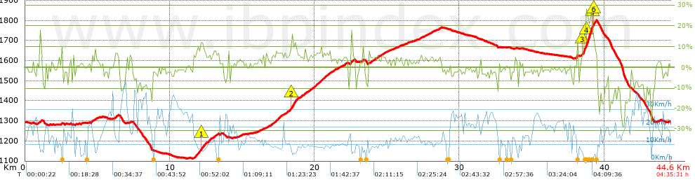
 Total length: 44.65 Km    mi / ft ?
 Analyzed distance: 44.65 Km
 Lineal distance: 0.06 Km
 Accumulated climb: 1088 m  info Points list
 Accumulated descent: 1078.8 m
 Maximum height: 1800.6 m
 Minimal height: 1112 m
 Start height: 1295.8 m
 End height : 1297.8 m
 Climb rate: 5.33 %
 Descent rate: 6.06 %
 Positive climb difference per Km: 24.37 m
 Negative descent difference per Km: 24.16 m
 Max slope filter: ~30 %
 Min. points separation: ~30 m
 Number of points: 2400   (cad. 18.6 m)
 Significant points: 1125   (cad. 39.72 m / 46.88 %)
 Direction changes per Km: 11.18
 Direction changes >5º per Km: 9.38
 Accumulated straight stretches: 4.904 Km
 Straight stretches per Km: 109.83 m
 Penalizables slope changes: 10
 Penalizables slope changes per Km: 0.224
 Total time: 4:35:31 h
 Time in movement: 3:12:11 h
 Stopped time: 1:23:20 h
 Total speed average: 9.72 Km/h
 Average speed in movement : 13.94 Km/h
 Maximum held speed: 47.28 Km/h
Your fitness level
24


Altitude Slope % Speed Km/h Speed < 2 Km/h

Steep slopes > 5%

Steep slopes >5% Steep slopes >10% Steep slopes >15% Steep slopes >20% Steep slopes >25%
 Steep slope of 113 m.  Average slope  Interval  Download as waypoint
1
 km 1.043  13%  113 m
 Steep slope of 102 m.  Average slope  Interval  Download as waypoint
2
 km 4.611  9%  102 m
 Steep slope of 227 m.  Average slope  Interval  Download as waypoint
3
 km 6.189  7%  227 m
 Steep slope of 805 m.  Average slope  Interval  Download as waypoint
4
 km 11.639  8%  479 m
5
 km 12.118  11%  148 m
6
 km 12.266  9%  178 m
 Steep slope of 199 m.  Average slope  Interval  Download as waypoint
7
 km 12.61  6%  199 m
 Steep slope of 214 m.  Average slope  Interval  Download as waypoint
8
 km 12.92  5%  214 m
 Steep slope of 114 m.  Average slope  Interval  Download as waypoint
9
 km 13.248  6%  114 m
 Steep slope of 195 m.  Average slope  Interval  Download as waypoint
10
 km 16.953  5%  195 m
 Steep slope of 488 m.  Average slope  Interval  Download as waypoint
11
 km 17.266  7%  488 m
 Steep slope of 251 m.  Average slope  Interval  Download as waypoint
12
 km 17.941  5%  251 m
 Steep slope of 618 m.  Average slope  Interval  Download as waypoint
13
 km 18.312  8%  71 m
14
 km 18.383  12%  357 m
15
 km 18.741  6%  190 m
 Steep slope of 224 m.  Average slope  Interval  Download as waypoint
16
 km 19.132  6%  224 m
 Steep slope of 141 m.  Average slope  Interval  Download as waypoint
17
 km 19.563  5%  141 m
 Steep slope of 1180 m.  Average slope  Interval  Download as waypoint
18
 km 19.851  6%  1180 m
 Steep slope of 124 m.  Average slope  Interval  Download as waypoint
19
 km 22.052  5%  124 m
 Steep slope of 201 m.  Average slope  Interval  Download as waypoint
20
 km 22.51  10%  201 m
 Steep slope of 154 m.  Average slope  Interval  Download as waypoint
21
 km 24.155  5%  154 m
 Steep slope of 194 m.  Average slope  Interval  Download as waypoint
22
 km 24.597  5%  194 m
 Steep slope of 1047 m.  Average slope  Interval  Download as waypoint
23
 km 38.359  5%  131 m
24
 km 38.489  12%  242 m
25
 km 38.731  23%  450 m
26
 km 39.181  18%  74 m
27
 km 39.255  13%  108 m
28
 km 39.363  11%  42 m


Compare this trail with...
Select trails to compare from "My trails". 
demo_montnegrebtt_2013.trk Ref.: 36172170671632
demo_matagalls_montserrat.trk Ref.: 36172170846048
demo_marathon_madrid_2013.trk Ref.: 36172170699197
Compare


Download (Registered users)

  GPX (.gpx)
  Garmin Training Center (.tcx)
  CompeGPS (.trk)
  OziExplorer (.plt)
  Google Earth (.kml)
  PDF analysis


Remove track and analysis
Save this trail on "My trails"


Send this analysis to a friend (Registered users)
Message that will receive your friend:
Re:
Hi.
(your name) has considered that this analysis of a trail could be of your interest.

(he/she will see a link to this page)
E-mail of your friend
You can enter multiple addresses separated by commas
Text
 
Send to a friend