User: Password:   Login   Login with Facebook   Register

Send to a friend
   

Detailed analysis of the trail analyzed as Bicycle (BYC)
Trail difficulty
125
BYC
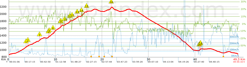
Track : aragon-huesca-miradores-ordesa.gpx
These speeds are average for : BYC (Bicycle)
Reanalyze as
HKG (Hiking) RNG (Running)
 Penalty trail's conditions: 56 %   ( > 50 % = MTB, < 50 % = RDB)
 Reliability of the original trail: A   (1625/88/0/-/-/88)
 Level of correction applied to the trail: 0
 Total length: 49.28 Km    mi / ft ?
 Analyzed distance: 49.28 Km
 Lineal distance: 0 Km
 Accumulated climb: 1625.2 m  info Points list
 Accumulated descent: 1608.8 m
 Maximum height: 2190.6 m
 Minimal height: 866.8 m
 Start height: 867.6 m
 End height : 885.2 m
 Climb rate: 7.53 %
 Descent rate: 6.92 %
 Positive climb difference per Km: 32.98 m
 Negative descent difference per Km: 32.65 m
 Max slope filter: ~30 %
 Min. points separation: ~30 m
 Number of points: 2653   (cad. 18.58 m)
 Significant points: 1204   (cad. 40.97 m / 45.38 %)
 Direction changes per Km: 9.17
 Direction changes >5º per Km: 6.09
 Accumulated straight stretches: 9.854 Km
 Straight stretches per Km: 199.96 m
 Penalizables slope changes: 12
 Penalizables slope changes per Km: 0.243
 Total time: 4:55:16 h
 Time in movement: 4:17:19 h
 Stopped time: 0:37:57 h
 Total speed average: 10.01 Km/h
 Average speed in movement : 11.49 Km/h
 Maximum held speed: 63.43 Km/h
Your fitness level
51


Altitude Slope % Speed Km/h Speed < 2 Km/h

Steep slopes > 10%

Steep slopes >5% Steep slopes >10% Steep slopes >15% Steep slopes >20% Steep slopes >25%
 Steep slope of 751 m.  Average slope  Interval  Download as waypoint
1
 km 3.616  10%  151 m
2
 km 4.02  11%  180 m
3
 km 6.404  11%  420 m
 Steep slope of 2151 m.  Average slope  Interval  Download as waypoint
4
 km 8.428  12%  159 m
5
 km 8.587  10%  832 m
6
 km 9.419  14%  738 m
7
 km 11.036  13%  56 m
8
 km 11.092  17%  99 m
9
 km 11.191  15%  267 m
 Steep slope of 451 m.  Average slope  Interval  Download as waypoint
10
 km 11.825  11%  230 m
11
 km 13.022  16%  221 m
 Steep slope of 304 m.  Average slope  Interval  Download as waypoint
12
 km 13.601  10%  115 m
13
 km 14.612  10%  189 m
 Steep slope of 819 m.  Average slope  Interval  Download as waypoint
14
 km 15.519  14%  819 m
 Steep slope of 153 m.  Average slope  Interval  Download as waypoint
15
 km 16.632  12%  153 m
 Steep slope of 336 m.  Average slope  Interval  Download as waypoint
16
 km 21.721  16%  336 m
 Steep slope of 347 m.  Average slope  Interval  Download as waypoint
17
 km 40.866  12%  165 m
18
 km 41.032  16%  111 m
19
 km 41.143  13%  71 m


Compare this trail with...
Select trails to compare from "My trails". 
demo_montnegrebtt_2013.trk Ref.: 36172170671632
demo_matagalls_montserrat.trk Ref.: 36172170846048
demo_marathon_madrid_2013.trk Ref.: 36172170699197
Compare


Download (Registered users)

  GPX (.gpx)
  Garmin Training Center (.tcx)
  CompeGPS (.trk)
  OziExplorer (.plt)
  Google Earth (.kml)
  PDF analysis


Remove track and analysis
Save this trail on "My trails"


Send this analysis to a friend (Registered users)
Message that will receive your friend:
Re:
Hi.
(your name) has considered that this analysis of a trail could be of your interest.

(he/she will see a link to this page)
E-mail of your friend
You can enter multiple addresses separated by commas
Text
 
Send to a friend