Trail difficulty
16
BYC
|
| Track : andalucia-cadiz-via-verde-entre-rios.gpx |
|
These speeds are average for : BYC
(Bicycle) Reanalyze as HKG (Hiking) RNG (Running) |
| Penalty trail's conditions: 49 % ( > 50 % = MTB, < 50 % = RDB) |
|
|
Level of correction applied to the trail:
7
 See original analysis (without corrections) See original analysis (without corrections)
|
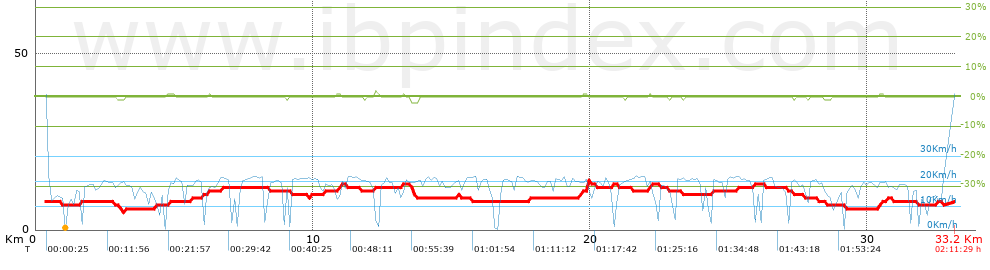
| Total length: 33.18 Km mi / ft ? |
| Analyzed distance: 33.18 Km |
| Lineal distance: 0 Km |
| Accumulated climb: 5.58 m |
info Points list |
| Accumulated descent: 4.24 m | |
| Maximum height: 13.55 m | |
| Minimal height: 5.34 m | |
| Start height: 7.7 m | |
| End height : 7.7 m | |
| Climb rate: 1.85 % | |
| Descent rate: 1.66 % | |
| Positive climb difference per Km: 0.17 m | |
| Negative descent difference per Km: 0.13 m | |
| Max slope filter: ~30 % |
| Min. points separation: ~30 m |
| Number of points: 634 (cad. 52.33 m) |
| Significant points: 529 (cad. 62.84 m / 83.44 %) |
| Direction changes per Km: 8.08 |
| Direction changes >5ş per Km: 0.9 |
| Accumulated straight stretches: 21.463 Km |
| Straight stretches per Km: 646.87 m |
| Penalizables slope changes: 0 |
| Penalizables slope changes per Km: 0 |
| Total time: 2:11:29 h |
| Time in movement: 2:11:29 h |
| Stopped time: 0:00:00 h |
| Total speed average: 15.14 Km/h |
| Average speed in movement : 15.14 Km/h |
| Maximum held speed: 24.15 Km/h |
Your fitness level
?*
|
 |
|
|
Remove track and analysis |
|
|
Save this trail on "My trails" |