User: Password:   Login   Login with Facebook   Register

Send to a friend
   

Detailed analysis of the trail analyzed as Bicycle (BYC)
Trail difficulty
106
BYC
Track : cataluna-barcelona-vuelta-montserrat.gpx
These speeds are average for : BYC (Bicycle)
Reanalyze as
HKG (Hiking) RNG (Running)
 Penalty trail's conditions: 71 %   ( > 50 % = MTB, < 50 % = RDB)
 Reliability of the original trail: B   (1442/62/0/-/-/62)
 Level of correction applied to the trail: 0
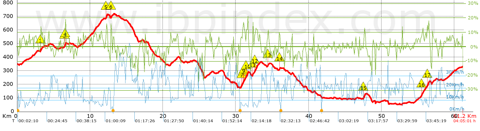
 Total length: 61.18 Km    mi / ft ?
 Analyzed distance: 61.18 Km
 Lineal distance: 0.11 Km
 Accumulated climb: 1442.2 m  info Points list
 Accumulated descent: 1459.4 m
 Maximum height: 716.8 m
 Minimal height: 51.3 m
 Start height: 352.9 m
 End height : 327.4 m
 Climb rate: 5.94 %
 Descent rate: 6.07 %
 Positive climb difference per Km: 23.57 m
 Negative descent difference per Km: 23.85 m
 Max slope filter: ~30 %
 Min. points separation: ~30 m
 Number of points: 4809   (cad. 12.72 m)
 Significant points: 1734   (cad. 35.3 m / 36.06 %)
 Direction changes per Km: 11.39
 Direction changes >5º per Km: 8.55
 Accumulated straight stretches: 9.422 Km
 Straight stretches per Km: 154 m
 Penalizables slope changes: 13
 Penalizables slope changes per Km: 0.212
 Total time: 4:05:01 h
 Time in movement: 3:44:10 h
 Stopped time: 0:20:51 h
 Total speed average: 14.98 Km/h
 Average speed in movement : 16.38 Km/h
 Maximum held speed: 58.61 Km/h
Your fitness level
13


Altitude Slope % Speed Km/h Speed < 2 Km/h

Steep slopes > 5%

Steep slopes >5% Steep slopes >10% Steep slopes >15% Steep slopes >20% Steep slopes >25%
 Steep slope of 385 m.  Average slope  Interval  Download as waypoint
1
 km 0.602  6%  385 m
 Steep slope of 267 m.  Average slope  Interval  Download as waypoint
2
 km 1.82  6%  267 m
 Steep slope of 402 m.  Average slope  Interval  Download as waypoint
3
 km 2.289  7%  402 m
 Steep slope of 339 m.  Average slope  Interval  Download as waypoint
4
 km 3.156  7%  33 m
5
 km 3.189  14%  103 m
6
 km 3.292  7%  203 m
 Steep slope of 137 m.  Average slope  Interval  Download as waypoint
7
 km 4.232  9%  137 m
 Steep slope of 164 m.  Average slope  Interval  Download as waypoint
8
 km 6.477  13%  32 m
9
 km 6.509  14%  99 m
10
 km 6.609  12%  33 m
 Steep slope of 105 m.  Average slope  Interval  Download as waypoint
11
 km 8.282  6%  105 m
 Steep slope of 142 m.  Average slope  Interval  Download as waypoint
12
 km 8.633  5%  142 m
 Steep slope of 234 m.  Average slope  Interval  Download as waypoint
13
 km 8.99  7%  234 m
 Steep slope of 490 m.  Average slope  Interval  Download as waypoint
14
 km 9.327  6%  490 m
 Steep slope of 244 m.  Average slope  Interval  Download as waypoint
15
 km 9.92  7%  244 m
 Steep slope of 542 m.  Average slope  Interval  Download as waypoint
16
 km 10.378  9%  542 m
 Steep slope of 530 m.  Average slope  Interval  Download as waypoint
17
 km 11.062  8%  530 m
 Steep slope of 102 m.  Average slope  Interval  Download as waypoint
18
 km 11.729  9%  102 m
 Steep slope of 275 m.  Average slope  Interval  Download as waypoint
19
 km 12.086  7%  109 m
20
 km 12.195  14%  166 m
 Steep slope of 116 m.  Average slope  Interval  Download as waypoint
21
 km 12.835  17%  116 m
 Steep slope of 139 m.  Average slope  Interval  Download as waypoint
22
 km 13.1  6%  139 m
 Steep slope of 202 m.  Average slope  Interval  Download as waypoint
23
 km 20.95  8%  202 m
 Steep slope of 102 m.  Average slope  Interval  Download as waypoint
24
 km 21.6  6%  102 m
 Steep slope of 226 m.  Average slope  Interval  Download as waypoint
25
 km 21.838  7%  226 m
 Steep slope of 107 m.  Average slope  Interval  Download as waypoint
26
 km 23.648  7%  107 m
 Steep slope of 208 m.  Average slope  Interval  Download as waypoint
27
 km 25.805  6%  208 m
 Steep slope of 107 m.  Average slope  Interval  Download as waypoint
28
 km 26.367  7%  107 m
 Steep slope of 132 m.  Average slope  Interval  Download as waypoint
29
 km 26.612  6%  132 m
 Steep slope of 105 m.  Average slope  Interval  Download as waypoint
30
 km 27.573  7%  105 m
 Steep slope of 984 m.  Average slope  Interval  Download as waypoint
31
 km 30.634  8%  164 m
32
 km 30.798  12%  127 m
33
 km 30.925  11%  97 m
34
 km 31.022  12%  263 m
35
 km 31.285  6%  103 m
36
 km 31.388  12%  230 m
 Steep slope of 238 m.  Average slope  Interval  Download as waypoint
37
 km 32.255  15%  102 m
38
 km 32.357  7%  136 m
 Steep slope of 459 m.  Average slope  Interval  Download as waypoint
39
 km 32.596  12%  330 m
40
 km 32.926  9%  129 m
 Steep slope of 138 m.  Average slope  Interval  Download as waypoint
41
 km 33.195  8%  138 m
 Steep slope of 305 m.  Average slope  Interval  Download as waypoint
42
 km 34.302  7%  69 m
43
 km 34.371  11%  97 m
44
 km 34.469  5%  139 m
 Steep slope of 198 m.  Average slope  Interval  Download as waypoint
45
 km 35.892  6%  36 m
46
 km 35.928  12%  99 m
47
 km 36.027  7%  63 m
 Steep slope of 138 m.  Average slope  Interval  Download as waypoint
48
 km 37.584  7%  138 m
 Steep slope of 113 m.  Average slope  Interval  Download as waypoint
49
 km 40.628  8%  113 m
 Steep slope of 104 m.  Average slope  Interval  Download as waypoint
50
 km 46.395  6%  104 m
 Steep slope of 302 m.  Average slope  Interval  Download as waypoint
51
 km 47.451  11%  204 m
52
 km 47.656  12%  98 m
 Steep slope of 96 m.  Average slope  Interval  Download as waypoint
53
 km 52.797  11%  96 m
 Steep slope of 173 m.  Average slope  Interval  Download as waypoint
54
 km 54.467  5%  173 m
 Steep slope of 100 m.  Average slope  Interval  Download as waypoint
55
 km 54.885  5%  100 m
 Steep slope of 1203 m.  Average slope  Interval  Download as waypoint
56
 km 55.319  6%  141 m
57
 km 55.46  10%  165 m
58
 km 55.625  8%  606 m
59
 km 56.23  13%  192 m
60
 km 56.422  12%  99 m
 Steep slope of 273 m.  Average slope  Interval  Download as waypoint
61
 km 56.865  7%  273 m
 Steep slope of 185 m.  Average slope  Interval  Download as waypoint
62
 km 59.348  5%  185 m
 Steep slope of 307 m.  Average slope  Interval  Download as waypoint
63
 km 59.647  7%  307 m
 Steep slope of 151 m.  Average slope  Interval  Download as waypoint
64
 km 60.187  5%  151 m


Compare this trail with...
Select trails to compare from "My trails". 
demo_montnegrebtt_2013.trk Ref.: 36172170671632
demo_matagalls_montserrat.trk Ref.: 36172170846048
demo_marathon_madrid_2013.trk Ref.: 36172170699197
Compare


Download (Registered users)

  GPX (.gpx)
  Garmin Training Center (.tcx)
  CompeGPS (.trk)
  OziExplorer (.plt)
  Google Earth (.kml)
  PDF analysis


Remove track and analysis
Save this trail on "My trails"


Send this analysis to a friend (Registered users)
Message that will receive your friend:
Re:
Hi.
(your name) has considered that this analysis of a trail could be of your interest.

(he/she will see a link to this page)
E-mail of your friend
You can enter multiple addresses separated by commas
Text
 
Send to a friend