User: Password:   Login   Login with Facebook   Register

Send to a friend
   

Detailed analysis of the trail analyzed as Hiking (HKG)
Trail difficulty
140
HKG
Track : sierra_occidental.gpx
These speeds are average for : RNG (Running)
Reanalyze as
BYC (Bicycle) RNG (Running)
 Reliability of the original trail: B   (1033/67/0/-/-/67)
 Level of correction applied to the trail: 0
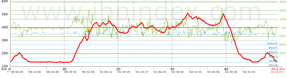
 Total length: 49.41 Km    mi / ft ?
 Analyzed distance: 49.41 Km
 Lineal distance: 0 Km
 Accumulated climb: 1032.9 m  info Points list
 Accumulated descent: 1033.4 m
 Maximum height: 508.1 m
 Minimal height: 130.6 m
 Start height: 137.6 m
 End height : 137.6 m
 Climb rate: 5.47 %
 Descent rate: 5.28 %
 Positive climb difference per Km: 20.9 m
 Negative descent difference per Km: 20.91 m
 Max slope filter: ~55 %
 Min. points separation: ~30 m
 Number of points: 2515   (cad. 19.65 m)
 Significant points: 1050   (cad. 47.11 m / 41.75 %)
 Direction changes per Km: 9.21
 Direction changes >5º per Km: 6.88
 Accumulated straight stretches: 10.442 Km
 Straight stretches per Km: 211.33 m
 Penalizables slope changes: 10
 Penalizables slope changes per Km: 0.202
 Total time: 3:18:07 h
 Time in movement: 3:18:07 h
 Stopped time: 0:00:00 h
 Total speed average: 14.97 Km/h
 Average speed in movement : 14.96 Km/h
 Maximum held speed: 16.76 Km/h


Altitude Slope % Speed Km/h Speed < 0.5 Km/h

Steep slopes > 5%

Steep slopes >5% Steep slopes >10% Steep slopes >15% Steep slopes >20% Steep slopes >25%
 Steep slope of 620 m.  Average slope  Interval  Download as waypoint
1
 km 0.379  5%  620 m
 Steep slope of 1426 m.  Average slope  Interval  Download as waypoint
2
 km 11.494  8%  216 m
3
 km 11.71  12%  148 m
4
 km 11.857  9%  413 m
5
 km 12.27  10%  163 m
6
 km 12.433  9%  230 m
7
 km 12.663  10%  133 m
8
 km 12.796  9%  123 m
 Steep slope of 234 m.  Average slope  Interval  Download as waypoint
9
 km 13.184  7%  195 m
10
 km 13.379  12%  39 m
 Steep slope of 116 m.  Average slope  Interval  Download as waypoint
11
 km 13.533  11%  116 m
 Steep slope of 709 m.  Average slope  Interval  Download as waypoint
12
 km 14.21  7%  186 m
13
 km 14.396  15%  40 m
14
 km 14.435  17%  35 m
15
 km 14.471  22%  119 m
16
 km 14.59  18%  39 m
17
 km 14.629  14%  75 m
18
 km 14.704  6%  215 m
 Steep slope of 246 m.  Average slope  Interval  Download as waypoint
19
 km 15.095  14%  138 m
20
 km 15.233  6%  108 m
 Steep slope of 196 m.  Average slope  Interval  Download as waypoint
21
 km 16.907  8%  196 m
 Steep slope of 270 m.  Average slope  Interval  Download as waypoint
22
 km 18.028  8%  63 m
23
 km 18.091  15%  103 m
24
 km 18.194  6%  104 m
 Steep slope of 246 m.  Average slope  Interval  Download as waypoint
25
 km 21.77  11%  179 m
26
 km 21.949  9%  67 m
 Steep slope of 117 m.  Average slope  Interval  Download as waypoint
27
 km 24.164  7%  117 m
 Steep slope of 112 m.  Average slope  Interval  Download as waypoint
28
 km 25.787  8%  112 m
 Steep slope of 494 m.  Average slope  Interval  Download as waypoint
29
 km 28.544  7%  175 m
30
 km 28.718  11%  177 m
31
 km 28.895  8%  142 m
 Steep slope of 152 m.  Average slope  Interval  Download as waypoint
32
 km 30.601  8%  152 m
 Steep slope of 139 m.  Average slope  Interval  Download as waypoint
33
 km 31.528  7%  139 m
 Steep slope of 182 m.  Average slope  Interval  Download as waypoint
34
 km 31.781  7%  38 m
35
 km 31.818  12%  102 m
36
 km 31.92  7%  42 m
 Steep slope of 186 m.  Average slope  Interval  Download as waypoint
37
 km 32.25  8%  186 m
 Steep slope of 176 m.  Average slope  Interval  Download as waypoint
38
 km 32.543  9%  176 m
 Steep slope of 103 m.  Average slope  Interval  Download as waypoint
39
 km 34.688  10%  103 m
 Steep slope of 118 m.  Average slope  Interval  Download as waypoint
40
 km 37.982  7%  118 m
 Steep slope of 262 m.  Average slope  Interval  Download as waypoint
41
 km 38.778  9%  74 m
42
 km 38.852  12%  150 m
43
 km 39.001  17%  38 m
 Steep slope of 310 m.  Average slope  Interval  Download as waypoint
44
 km 39.139  18%  170 m
45
 km 39.309  10%  33 m
46
 km 39.343  8%  107 m
 Steep slope of 376 m.  Average slope  Interval  Download as waypoint
47
 km 47.11  8%  376 m


Compare this trail with...
Select trails to compare from "My trails". 
demo_montnegrebtt_2013.trk Ref.: 36172170671632
demo_matagalls_montserrat.trk Ref.: 36172170846048
demo_marathon_madrid_2013.trk Ref.: 36172170699197
Compare


Download (Registered users)

  GPX (.gpx)
  Garmin Training Center (.tcx)
  CompeGPS (.trk)
  OziExplorer (.plt)
  Google Earth (.kml)
  PDF analysis


Remove track and analysis
Save this trail on "My trails"


Send this analysis to a friend (Registered users)
Message that will receive your friend:
Re:
Hi.
(your name) has considered that this analysis of a trail could be of your interest.

(he/she will see a link to this page)
E-mail of your friend
You can enter multiple addresses separated by commas
Text
 
Send to a friend