User: Password:   Login   Login with Facebook   Register

Send to a friend
   

Detailed analysis of the trail analyzed as Bicycle (BYC)
Trail difficulty
49
BYC
Track : aragon-zaragoza-sendas-villamayor-dragon-khan.gpx
These speeds are average for : BYC (Bicycle)
Reanalyze as
HKG (Hiking) RNG (Running)
 Penalty trail's conditions: 77 %   ( > 50 % = MTB, < 50 % = RDB)
 Reliability of the original trail: C   (759/51/1/16/-/75)
 Level of correction applied to the trail: 1        See original analysis (without corrections)
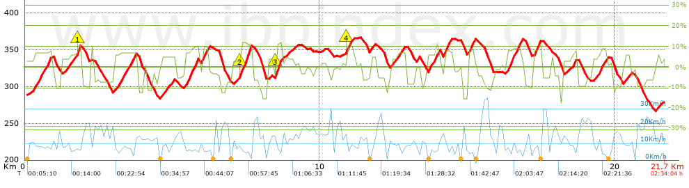
 Total length: 21.66 Km    mi / ft ?
 Analyzed distance: 21.66 Km
 Lineal distance: 0 Km
 Accumulated climb: 674.31 m  info Points list
 Accumulated descent: 682.87 m
 Maximum height: 366.98 m
 Minimal height: 266.94 m
 Start height: 286.8 m
 End height : 279.2 m
 Climb rate: 6.2 %
 Descent rate: 7.07 %
 Positive climb difference per Km: 31.13 m
 Negative descent difference per Km: 31.53 m
 Max slope filter: ~30 %
 Min. points separation: ~30 m
 Number of points: 1399   (cad. 15.48 m)
 Significant points: 578   (cad. 37.61 m / 41.32 %)
 Direction changes per Km: 12.42
 Direction changes >5º per Km: 10.2
 Accumulated straight stretches: 2.144 Km
 Straight stretches per Km: 98.98 m
 Penalizables slope changes: 3
 Penalizables slope changes per Km: 0.139
 Total time: 2:34:04 h
 Time in movement: 1:59:44 h
 Stopped time: 0:34:20 h
 Total speed average: 8.44 Km/h
 Average speed in movement : 10.85 Km/h
 Maximum held speed: 36.48 Km/h
Your fitness level
45


Altitude Slope % Speed Km/h Speed < 2 Km/h

Steep slopes > 5%

Steep slopes >5% Steep slopes >10% Steep slopes >15% Steep slopes >20% Steep slopes >25%
 Steep slope of 628 m.  Average slope  Interval  Download as waypoint
1
 km 0.291  7%  628 m
 Steep slope of 441 m.  Average slope  Interval  Download as waypoint
2
 km 1.466  6%  289 m
3
 km 1.754  11%  120 m
4
 km 1.874  8%  32 m
 Steep slope of 782 m.  Average slope  Interval  Download as waypoint
5
 km 3.008  7%  782 m
 Steep slope of 257 m.  Average slope  Interval  Download as waypoint
6
 km 4.801  5%  257 m
 Steep slope of 478 m.  Average slope  Interval  Download as waypoint
7
 km 5.39  8%  478 m
 Steep slope of 243 m.  Average slope  Interval  Download as waypoint
8
 km 5.987  10%  243 m
 Steep slope of 412 m.  Average slope  Interval  Download as waypoint
9
 km 7.263  7%  45 m
10
 km 7.309  11%  367 m
 Steep slope of 221 m.  Average slope  Interval  Download as waypoint
11
 km 8.489  12%  221 m
 Steep slope of 183 m.  Average slope  Interval  Download as waypoint
12
 km 10.873  5%  36 m
13
 km 10.908  11%  147 m
 Steep slope of 213 m.  Average slope  Interval  Download as waypoint
14
 km 11.663  5%  213 m
 Steep slope of 325 m.  Average slope  Interval  Download as waypoint
15
 km 12.586  6%  325 m
 Steep slope of 391 m.  Average slope  Interval  Download as waypoint
16
 km 13.623  8%  391 m
 Steep slope of 296 m.  Average slope  Interval  Download as waypoint
17
 km 14.163  8%  296 m
 Steep slope of 254 m.  Average slope  Interval  Download as waypoint
18
 km 14.996  9%  254 m
 Steep slope of 529 m.  Average slope  Interval  Download as waypoint
19
 km 16.32  8%  529 m
 Steep slope of 304 m.  Average slope  Interval  Download as waypoint
20
 km 17.214  8%  304 m
 Steep slope of 185 m.  Average slope  Interval  Download as waypoint
21
 km 18.518  8%  185 m
 Steep slope of 275 m.  Average slope  Interval  Download as waypoint
22
 km 19.443  9%  275 m
 Steep slope of 258 m.  Average slope  Interval  Download as waypoint
23
 km 20.28  6%  258 m
 Steep slope of 149 m.  Average slope  Interval  Download as waypoint
24
 km 21.389  6%  149 m


Compare this trail with...
Select trails to compare from "My trails". 
demo_montnegrebtt_2013.trk Ref.: 36172170671632
demo_matagalls_montserrat.trk Ref.: 36172170846048
demo_marathon_madrid_2013.trk Ref.: 36172170699197
Compare


Download (Registered users)

  GPX (.gpx)
  Garmin Training Center (.tcx)
  CompeGPS (.trk)
  OziExplorer (.plt)
  Google Earth (.kml)
  PDF analysis


Remove track and analysis
Save this trail on "My trails"


Send this analysis to a friend (Registered users)
Message that will receive your friend:
Re:
Hi.
(your name) has considered that this analysis of a trail could be of your interest.

(he/she will see a link to this page)
E-mail of your friend
You can enter multiple addresses separated by commas
Text
 
Send to a friend