User: Password:   Login   Login with Facebook   Register

Send to a friend
   

Detailed analysis of the trail analyzed as Bicycle (BYC)
Trail difficulty
116
BYC
Track : completo_aragon-huesca-castillo-mora.gpx
These speeds are average for : BYC (Bicycle)
Reanalyze as
HKG (Hiking) RNG (Running)
 Penalty trail's conditions: 58 %   ( > 50 % = MTB, < 50 % = RDB)
 Reliability of the original trail: C   (1558/57/0/-/-/57)
 Level of correction applied to the trail: 0
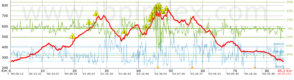
 Total length: 85.19 Km    mi / ft ?
 Analyzed distance: 85.19 Km
 Lineal distance: 0.02 Km
 Accumulated climb: 1556.39 m  info Points list
 Accumulated descent: 1562.29 m
 Maximum height: 752.7 m
 Minimal height: 261.8 m
 Start height: 261.8 m
 End height : 261.9 m
 Climb rate: 4.92 %
 Descent rate: 4.66 %
 Positive climb difference per Km: 18.27 m
 Negative descent difference per Km: 18.34 m
 Max slope filter: ~30 %
 Min. points separation: ~30 m
 Number of points: 5800   (cad. 14.69 m)
 Significant points: 2299   (cad. 37.07 m / 39.64 %)
 Direction changes per Km: 11.63
 Direction changes >5º per Km: 8.1
 Accumulated straight stretches: 18.489 Km
 Straight stretches per Km: 217.03 m
 Penalizables slope changes: 14
 Penalizables slope changes per Km: 0.164
 Total time: 4:54:19 h
 Time in movement: 4:42:29 h
 Stopped time: 0:11:50 h
 Total speed average: 17.37 Km/h
 Average speed in movement : 18.09 Km/h
 Maximum held speed: 50.06 Km/h
Your fitness level
20


Altitude Slope % Speed Km/h Speed < 2 Km/h

Steep slopes > 5%

Steep slopes >5% Steep slopes >10% Steep slopes >15% Steep slopes >20% Steep slopes >25%
 Steep slope of 119 m.  Average slope  Interval  Download as waypoint
1
 km 2.093  6%  119 m
 Steep slope of 105 m.  Average slope  Interval  Download as waypoint
2
 km 2.995  8%  105 m
 Steep slope of 292 m.  Average slope  Interval  Download as waypoint
3
 km 5.947  8%  292 m
 Steep slope of 221 m.  Average slope  Interval  Download as waypoint
4
 km 9.608  7%  221 m
 Steep slope of 141 m.  Average slope  Interval  Download as waypoint
5
 km 15.825  8%  141 m
 Steep slope of 208 m.  Average slope  Interval  Download as waypoint
6
 km 19.288  7%  35 m
7
 km 19.323  11%  103 m
8
 km 19.425  7%  70 m
 Steep slope of 207 m.  Average slope  Interval  Download as waypoint
9
 km 19.907  9%  207 m
 Steep slope of 214 m.  Average slope  Interval  Download as waypoint
10
 km 21.009  7%  214 m
 Steep slope of 168 m.  Average slope  Interval  Download as waypoint
11
 km 24.482  9%  34 m
12
 km 24.516  13%  100 m
13
 km 24.615  10%  34 m
 Steep slope of 360 m.  Average slope  Interval  Download as waypoint
14
 km 25.711  6%  360 m
 Steep slope of 526 m.  Average slope  Interval  Download as waypoint
15
 km 26.494  7%  140 m
16
 km 26.635  12%  102 m
17
 km 26.737  7%  284 m
 Steep slope of 111 m.  Average slope  Interval  Download as waypoint
18
 km 28.385  5%  111 m
 Steep slope of 257 m.  Average slope  Interval  Download as waypoint
19
 km 28.72  8%  257 m
 Steep slope of 107 m.  Average slope  Interval  Download as waypoint
20
 km 34.685  9%  107 m
 Steep slope of 461 m.  Average slope  Interval  Download as waypoint
21
 km 35.489  11%  170 m
22
 km 35.658  7%  291 m
 Steep slope of 364 m.  Average slope  Interval  Download as waypoint
23
 km 36.771  7%  364 m
 Steep slope of 218 m.  Average slope  Interval  Download as waypoint
24
 km 38.597  7%  218 m
 Steep slope of 238 m.  Average slope  Interval  Download as waypoint
25
 km 41.57  9%  238 m
 Steep slope of 427 m.  Average slope  Interval  Download as waypoint
26
 km 42.343  8%  33 m
27
 km 42.376  13%  262 m
28
 km 42.638  10%  132 m
 Steep slope of 214 m.  Average slope  Interval  Download as waypoint
29
 km 43.554  12%  105 m
30
 km 43.66  6%  109 m
 Steep slope of 516 m.  Average slope  Interval  Download as waypoint
31
 km 43.875  10%  225 m
32
 km 44.1  10%  150 m
33
 km 44.25  13%  141 m
 Steep slope of 300 m.  Average slope  Interval  Download as waypoint
34
 km 44.786  9%  38 m
35
 km 44.824  11%  223 m
36
 km 45.047  20%  39 m
 Steep slope of 151 m.  Average slope  Interval  Download as waypoint
37
 km 45.224  24%  151 m
 Steep slope of 248 m.  Average slope  Interval  Download as waypoint
38
 km 45.649  9%  106 m
39
 km 45.755  22%  109 m
40
 km 45.864  16%  33 m
 Steep slope of 260 m.  Average slope  Interval  Download as waypoint
41
 km 46.304  19%  48 m
42
 km 46.351  28%  103 m
43
 km 46.454  12%  33 m
44
 km 46.486  10%  40 m
45
 km 46.527  18%  36 m
 Steep slope of 313 m.  Average slope  Interval  Download as waypoint
46
 km 47.574  12%  102 m
47
 km 47.676  8%  107 m
48
 km 47.783  7%  104 m
 Steep slope of 481 m.  Average slope  Interval  Download as waypoint
49
 km 48.606  7%  100 m
50
 km 48.706  17%  143 m
51
 km 48.849  8%  133 m
52
 km 48.982  11%  105 m
 Steep slope of 157 m.  Average slope  Interval  Download as waypoint
53
 km 52.886  5%  157 m
 Steep slope of 119 m.  Average slope  Interval  Download as waypoint
54
 km 55.535  7%  119 m
 Steep slope of 625 m.  Average slope  Interval  Download as waypoint
55
 km 55.86  8%  625 m
 Steep slope of 138 m.  Average slope  Interval  Download as waypoint
56
 km 56.736  7%  138 m
 Steep slope of 115 m.  Average slope  Interval  Download as waypoint
57
 km 61.708  7%  115 m
 Steep slope of 280 m.  Average slope  Interval  Download as waypoint
58
 km 65.983  6%  280 m
 Steep slope of 186 m.  Average slope  Interval  Download as waypoint
59
 km 66.649  8%  186 m
 Steep slope of 104 m.  Average slope  Interval  Download as waypoint
60
 km 67.1  6%  104 m


Compare this trail with...
Select trails to compare from "My trails". 
demo_montnegrebtt_2013.trk Ref.: 36172170671632
demo_matagalls_montserrat.trk Ref.: 36172170846048
demo_marathon_madrid_2013.trk Ref.: 36172170699197
Compare


Download (Registered users)

  GPX (.gpx)
  Garmin Training Center (.tcx)
  CompeGPS (.trk)
  OziExplorer (.plt)
  Google Earth (.kml)
  PDF analysis


Remove track and analysis
Save this trail on "My trails"


Send this analysis to a friend (Registered users)
Message that will receive your friend:
Re:
Hi.
(your name) has considered that this analysis of a trail could be of your interest.

(he/she will see a link to this page)
E-mail of your friend
You can enter multiple addresses separated by commas
Text
 
Send to a friend