User: Password:   Login   Login with Facebook   Register

Send to a friend
   

Detailed analysis of the trail analyzed as Bicycle (BYC)
Trail difficulty
89
BYC
Track : andalucia-4-miradores-montes-malaga.gpx
These speeds are average for : BYC (Bicycle)
Reanalyze as
HKG (Hiking) RNG (Running)
 Penalty trail's conditions: 51 %   ( > 50 % = MTB, < 50 % = RDB)
 Reliability of the original trail: D   (2517/32/2/2/4/77)
 Level of correction applied to the trail: 6        See original analysis (without corrections)
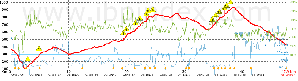
 Total length: 47.58 Km    mi / ft ?
 Analyzed distance: 47.58 Km
 Lineal distance: 1.03 Km
 Accumulated climb: 1293.98 m  info Points list
 Accumulated descent: 1220.04 m
 Maximum height: 931.62 m
 Minimal height: 105.14 m
 Start height: 360.4 m
 End height : 430.1 m
 Climb rate: 5.76 %
 Descent rate: 5.86 %
 Positive climb difference per Km: 27.2 m
 Negative descent difference per Km: 25.64 m
 Max slope filter: ~30 %
 Min. points separation: ~30 m
 Number of points: 3575   (cad. 13.31 m)
 Significant points: 1327   (cad. 36.04 m / 37.12 %)
 Direction changes per Km: 11.64
 Direction changes >5º per Km: 10.05
 Accumulated straight stretches: 4.815 Km
 Straight stretches per Km: 101.2 m
 Penalizables slope changes: 8
 Penalizables slope changes per Km: 0.168
 Total time: 6:29:50 h
 Time in movement: 4:07:27 h
 Stopped time: 2:22:23 h
 Total speed average: 7.32 Km/h
 Average speed in movement : 11.54 Km/h
 Maximum held speed: 58.28 Km/h
Your fitness level
56


Altitude Slope % Speed Km/h Speed < 2 Km/h

Steep slopes > 5%

Steep slopes >5% Steep slopes >10% Steep slopes >15% Steep slopes >20% Steep slopes >25%
 Steep slope of 99 m.  Average slope  Interval  Download as waypoint
1
 km 2.598  8%  99 m
 Steep slope of 2183 m.  Average slope  Interval  Download as waypoint
2
 km 2.928  9%  32 m
3
 km 2.96  17%  97 m
4
 km 3.057  6%  395 m
5
 km 3.452  7%  1368 m
6
 km 4.82  15%  130 m
7
 km 4.95  10%  161 m
 Steep slope of 99 m.  Average slope  Interval  Download as waypoint
8
 km 5.286  6%  99 m
 Steep slope of 170 m.  Average slope  Interval  Download as waypoint
9
 km 6.135  6%  170 m
 Steep slope of 280 m.  Average slope  Interval  Download as waypoint
10
 km 7.01  9%  280 m
 Steep slope of 167 m.  Average slope  Interval  Download as waypoint
11
 km 11.999  6%  167 m
 Steep slope of 199 m.  Average slope  Interval  Download as waypoint
12
 km 13.854  5%  199 m
 Steep slope of 241 m.  Average slope  Interval  Download as waypoint
13
 km 16.123  7%  241 m
 Steep slope of 108 m.  Average slope  Interval  Download as waypoint
14
 km 16.977  5%  108 m
 Steep slope of 719 m.  Average slope  Interval  Download as waypoint
15
 km 19.482  20%  96 m
16
 km 19.579  8%  391 m
17
 km 19.97  14%  232 m
 Steep slope of 107 m.  Average slope  Interval  Download as waypoint
18
 km 20.669  6%  107 m
 Steep slope of 1101 m.  Average slope  Interval  Download as waypoint
19
 km 21.495  6%  32 m
20
 km 21.527  13%  126 m
21
 km 21.653  7%  708 m
22
 km 22.361  17%  100 m
23
 km 22.461  7%  135 m
 Steep slope of 99 m.  Average slope  Interval  Download as waypoint
24
 km 22.926  11%  99 m
 Steep slope of 539 m.  Average slope  Interval  Download as waypoint
25
 km 23.478  7%  34 m
26
 km 23.512  16%  229 m
27
 km 23.741  11%  276 m
 Steep slope of 264 m.  Average slope  Interval  Download as waypoint
28
 km 24.551  12%  99 m
29
 km 24.651  6%  165 m
 Steep slope of 371 m.  Average slope  Interval  Download as waypoint
30
 km 27.967  8%  371 m
 Steep slope of 1033 m.  Average slope  Interval  Download as waypoint
31
 km 34.573  7%  317 m
32
 km 34.89  11%  161 m
33
 km 35.051  9%  422 m
34
 km 35.474  16%  102 m
35
 km 35.575  9%  31 m
 Steep slope of 460 m.  Average slope  Interval  Download as waypoint
36
 km 35.736  8%  290 m
37
 km 36.026  12%  133 m
38
 km 36.159  7%  37 m
 Steep slope of 934 m.  Average slope  Interval  Download as waypoint
39
 km 36.692  7%  293 m
40
 km 36.985  18%  112 m
41
 km 37.097  5%  229 m
42
 km 37.326  7%  32 m
43
 km 37.358  13%  234 m
44
 km 37.592  8%  34 m
 Steep slope of 262 m.  Average slope  Interval  Download as waypoint
45
 km 38.028  7%  34 m
46
 km 38.062  12%  122 m
47
 km 38.184  6%  106 m


Compare this trail with...
Select trails to compare from "My trails". 
demo_montnegrebtt_2013.trk Ref.: 36172170671632
demo_matagalls_montserrat.trk Ref.: 36172170846048
demo_marathon_madrid_2013.trk Ref.: 36172170699197
Compare


Download (Registered users)

  GPX (.gpx)
  Garmin Training Center (.tcx)
  CompeGPS (.trk)
  OziExplorer (.plt)
  Google Earth (.kml)
  PDF analysis


Remove track and analysis
Save this trail on "My trails"


Send this analysis to a friend (Registered users)
Message that will receive your friend:
Re:
Hi.
(your name) has considered that this analysis of a trail could be of your interest.

(he/she will see a link to this page)
E-mail of your friend
You can enter multiple addresses separated by commas
Text
 
Send to a friend