Trail difficulty
32
BYC
|
| Track : circular_humanes_-_rio_guadarrama.gpx |
|
These speeds are average for : BYC
(Bicycle) Reanalyze as HKG (Hiking) RNG (Running) |
| Penalty trail's conditions: 31 % ( > 50 % = MTB, < 50 % = RDB) |
|
|
Level of correction applied to the trail:
1
 See original analysis (without corrections) See original analysis (without corrections)
|
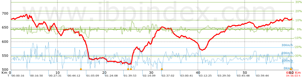
| Total length: 60.17 Km mi / ft ? |
| Analyzed distance: 60.17 Km |
| Lineal distance: 0.18 Km |
| Accumulated climb: 458.59 m |
info Points list |
| Accumulated descent: 477.41 m | |
| Maximum height: 697.17 m | |
| Minimal height: 519.71 m | |
| Start height: 679.6 m | |
| End height : 681.8 m | |
| Climb rate: 2.38 % | |
| Descent rate: 2.58 % | |
| Positive climb difference per Km: 7.62 m | |
| Negative descent difference per Km: 7.93 m | |
| Max slope filter: ~30 % |
| Min. points separation: ~30 m |
| Number of points: 911 (cad. 66.04 m) |
| Significant points: 757 (cad. 79.58 m / 83.1 %) |
| Direction changes per Km: 6.1 |
| Direction changes >5ş per Km: 4.77 |
| Accumulated straight stretches: 5.666 Km |
| Straight stretches per Km: 94.17 m |
| Penalizables slope changes: 4 |
| Penalizables slope changes per Km: 0.066 |
| Total time: 4:56:03 h |
| Time in movement: 4:09:50 h |
| Stopped time: 0:46:13 h |
| Total speed average: 12.19 Km/h |
| Average speed in movement : 14.45 Km/h |
| Maximum held speed: 37.63 Km/h |
Your fitness level
94
|
 |
|
|
Remove track and analysis |
|
|
Save this trail on "My trails" |