User: Password:   Login   Login with Facebook   Register

Send to a friend
   

Detailed analysis of the trail analyzed as Hiking (HKG)
Trail difficulty
638
HKG
Track : ruta_del_rey_fernando.gpx
These speeds are average for : RNG (Running)
Reanalyze as
BYC (Bicycle) RNG (Running)
 Reliability of the original trail: B   (5747/68/0/-/-/68)
 Level of correction applied to the trail: 0
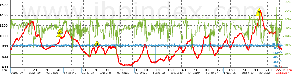
 Total length: 221.69 Km    mi / ft ?
 Analyzed distance: 221.69 Km
 Lineal distance: 0.02 Km
 Accumulated climb: 5748.1 m  info Points list
 Accumulated descent: 5747.8 m
 Maximum height: 1497.5 m
 Minimal height: 432 m
 Start height: 751.8 m
 End height : 747.7 m
 Climb rate: 5.44 %
 Descent rate: 6.77 %
 Positive climb difference per Km: 25.93 m
 Negative descent difference per Km: 25.93 m
 Max slope filter: ~55 %
 Min. points separation: ~30 m
 Number of points: 14023   (cad. 15.81 m)
 Significant points: 6136   (cad. 36.14 m / 43.76 %)
 Direction changes per Km: 11.43
 Direction changes >5º per Km: 8.06
 Accumulated straight stretches: 37.549 Km
 Straight stretches per Km: 169.38 m
 Penalizables slope changes: 56
 Penalizables slope changes per Km: 0.253
 Total time: 22:13:20 h
 Time in movement: 22:13:20 h
 Stopped time: 0:00:00 h
 Total speed average: 9.98 Km/h
 Average speed in movement : 9.98 Km/h
 Maximum held speed: 11.19 Km/h


Altitude Slope % Speed Km/h Speed < 0.5 Km/h

Steep slopes > 5%

Steep slopes >5% Steep slopes >10% Steep slopes >15% Steep slopes >20% Steep slopes >25%
 Steep slope of 252 m.  Average slope  Interval  Download as waypoint
1
 km 0.738  8%  252 m
 Steep slope of 559 m.  Average slope  Interval  Download as waypoint
2
 km 1.172  7%  559 m
 Steep slope of 146 m.  Average slope  Interval  Download as waypoint
3
 km 2.483  6%  146 m
 Steep slope of 136 m.  Average slope  Interval  Download as waypoint
4
 km 2.907  6%  136 m
 Steep slope of 169 m.  Average slope  Interval  Download as waypoint
5
 km 3.149  5%  169 m
 Steep slope of 99 m.  Average slope  Interval  Download as waypoint
6
 km 3.459  6%  99 m
 Steep slope of 269 m.  Average slope  Interval  Download as waypoint
7
 km 3.733  6%  269 m
 Steep slope of 269 m.  Average slope  Interval  Download as waypoint
8
 km 4.105  6%  269 m
 Steep slope of 330 m.  Average slope  Interval  Download as waypoint
9
 km 8.714  6%  330 m
 Steep slope of 104 m.  Average slope  Interval  Download as waypoint
10
 km 9.315  5%  104 m
 Steep slope of 1181 m.  Average slope  Interval  Download as waypoint
11
 km 10.596  6%  1181 m
 Steep slope of 411 m.  Average slope  Interval  Download as waypoint
12
 km 11.874  6%  411 m
 Steep slope of 469 m.  Average slope  Interval  Download as waypoint
13
 km 12.783  6%  469 m
 Steep slope of 395 m.  Average slope  Interval  Download as waypoint
14
 km 13.678  6%  395 m
 Steep slope of 1061 m.  Average slope  Interval  Download as waypoint
15
 km 15.678  8%  1061 m
 Steep slope of 346 m.  Average slope  Interval  Download as waypoint
16
 km 17.325  9%  97 m
17
 km 17.421  12%  146 m
18
 km 17.567  9%  103 m
 Steep slope of 152 m.  Average slope  Interval  Download as waypoint
19
 km 18.028  7%  152 m
 Steep slope of 139 m.  Average slope  Interval  Download as waypoint
20
 km 18.291  6%  139 m
 Steep slope of 101 m.  Average slope  Interval  Download as waypoint
21
 km 21.621  8%  101 m
 Steep slope of 132 m.  Average slope  Interval  Download as waypoint
22
 km 21.995  6%  132 m
 Steep slope of 137 m.  Average slope  Interval  Download as waypoint
23
 km 22.236  6%  137 m
 Steep slope of 186 m.  Average slope  Interval  Download as waypoint
24
 km 29.792  6%  186 m
 Steep slope of 104 m.  Average slope  Interval  Download as waypoint
25
 km 36.738  5%  104 m
 Steep slope of 463 m.  Average slope  Interval  Download as waypoint
26
 km 39.695  9%  36 m
27
 km 39.731  12%  37 m
28
 km 39.768  17%  110 m
29
 km 39.878  15%  38 m
30
 km 39.916  8%  242 m
 Steep slope of 334 m.  Average slope  Interval  Download as waypoint
31
 km 40.293  10%  117 m
32
 km 40.41  7%  110 m
33
 km 40.52  20%  107 m
 Steep slope of 179 m.  Average slope  Interval  Download as waypoint
34
 km 42.026  8%  179 m
 Steep slope of 100 m.  Average slope  Interval  Download as waypoint
35
 km 42.825  6%  100 m
 Steep slope of 239 m.  Average slope  Interval  Download as waypoint
36
 km 43.347  6%  239 m
 Steep slope of 176 m.  Average slope  Interval  Download as waypoint
37
 km 43.998  7%  176 m
 Steep slope of 324 m.  Average slope  Interval  Download as waypoint
38
 km 44.278  6%  324 m
 Steep slope of 814 m.  Average slope  Interval  Download as waypoint
39
 km 45.013  7%  814 m
 Steep slope of 100 m.  Average slope  Interval  Download as waypoint
40
 km 49.584  11%  100 m
 Steep slope of 185 m.  Average slope  Interval  Download as waypoint
41
 km 50.142  6%  185 m
 Steep slope of 142 m.  Average slope  Interval  Download as waypoint
42
 km 51.976  11%  142 m
 Steep slope of 140 m.  Average slope  Interval  Download as waypoint
43
 km 53.267  5%  140 m
 Steep slope of 169 m.  Average slope  Interval  Download as waypoint
44
 km 54.068  6%  169 m
 Steep slope of 116 m.  Average slope  Interval  Download as waypoint
45
 km 55.648  8%  116 m
 Steep slope of 104 m.  Average slope  Interval  Download as waypoint
46
 km 57.358  14%  104 m
 Steep slope of 137 m.  Average slope  Interval  Download as waypoint
47
 km 58.376  6%  137 m
 Steep slope of 1788 m.  Average slope  Interval  Download as waypoint
48
 km 65.322  8%  1788 m
 Steep slope of 144 m.  Average slope  Interval  Download as waypoint
49
 km 67.697  7%  144 m
 Steep slope of 273 m.  Average slope  Interval  Download as waypoint
50
 km 69.909  7%  273 m
 Steep slope of 256 m.  Average slope  Interval  Download as waypoint
51
 km 70.42  7%  188 m
52
 km 70.608  13%  68 m
 Steep slope of 294 m.  Average slope  Interval  Download as waypoint
53
 km 70.784  16%  109 m
54
 km 70.893  11%  112 m
55
 km 71.005  11%  73 m
 Steep slope of 155 m.  Average slope  Interval  Download as waypoint
56
 km 71.215  8%  155 m
 Steep slope of 149 m.  Average slope  Interval  Download as waypoint
57
 km 71.821  7%  149 m
 Steep slope of 104 m.  Average slope  Interval  Download as waypoint
58
 km 72.641  7%  104 m
 Steep slope of 391 m.  Average slope  Interval  Download as waypoint
59
 km 78.668  6%  391 m
 Steep slope of 137 m.  Average slope  Interval  Download as waypoint
60
 km 79.208  7%  137 m
 Steep slope of 311 m.  Average slope  Interval  Download as waypoint
61
 km 79.698  6%  311 m
 Steep slope of 340 m.  Average slope  Interval  Download as waypoint
62
 km 80.157  6%  340 m
 Steep slope of 240 m.  Average slope  Interval  Download as waypoint
63
 km 81.595  9%  240 m
 Steep slope of 96 m.  Average slope  Interval  Download as waypoint
64
 km 82.094  7%  96 m
 Steep slope of 216 m.  Average slope  Interval  Download as waypoint
65
 km 82.875  9%  216 m
 Steep slope of 291 m.  Average slope  Interval  Download as waypoint
66
 km 83.268  7%  291 m
 Steep slope of 143 m.  Average slope  Interval  Download as waypoint
67
 km 83.958  11%  143 m
 Steep slope of 113 m.  Average slope  Interval  Download as waypoint
68
 km 84.428  5%  113 m
 Steep slope of 120 m.  Average slope  Interval  Download as waypoint
69
 km 85.16  8%  120 m
 Steep slope of 103 m.  Average slope  Interval  Download as waypoint
70
 km 87.194  9%  103 m
 Steep slope of 98 m.  Average slope  Interval  Download as waypoint
71
 km 88.509  9%  98 m
 Steep slope of 123 m.  Average slope  Interval  Download as waypoint
72
 km 100.689  5%  123 m
 Steep slope of 193 m.  Average slope  Interval  Download as waypoint
73
 km 100.977  8%  193 m
 Steep slope of 173 m.  Average slope  Interval  Download as waypoint
74
 km 103.419  6%  173 m
 Steep slope of 103 m.  Average slope  Interval  Download as waypoint
75
 km 104.124  10%  103 m
 Steep slope of 112 m.  Average slope  Interval  Download as waypoint
76
 km 104.542  6%  112 m
 Steep slope of 259 m.  Average slope  Interval  Download as waypoint
77
 km 105.317  7%  259 m
 Steep slope of 301 m.  Average slope  Interval  Download as waypoint
78
 km 105.99  7%  301 m
 Steep slope of 242 m.  Average slope  Interval  Download as waypoint
79
 km 106.447  8%  242 m
 Steep slope of 229 m.  Average slope  Interval  Download as waypoint
80
 km 107.082  8%  229 m
 Steep slope of 447 m.  Average slope  Interval  Download as waypoint
81
 km 107.557  8%  447 m
 Steep slope of 1287 m.  Average slope  Interval  Download as waypoint
82
 km 108.206  8%  826 m
83
 km 109.032  13%  427 m
84
 km 109.46  12%  34 m
 Steep slope of 158 m.  Average slope  Interval  Download as waypoint
85
 km 110.421  9%  158 m
 Steep slope of 274 m.  Average slope  Interval  Download as waypoint
86
 km 118.17  6%  274 m
 Steep slope of 140 m.  Average slope  Interval  Download as waypoint
87
 km 119.336  7%  140 m
 Steep slope of 171 m.  Average slope  Interval  Download as waypoint
88
 km 119.959  8%  171 m
 Steep slope of 105 m.  Average slope  Interval  Download as waypoint
89
 km 120.584  6%  105 m
 Steep slope of 315 m.  Average slope  Interval  Download as waypoint
90
 km 121.211  5%  315 m
 Steep slope of 104 m.  Average slope  Interval  Download as waypoint
91
 km 121.779  9%  104 m
 Steep slope of 212 m.  Average slope  Interval  Download as waypoint
92
 km 125.703  6%  212 m
 Steep slope of 105 m.  Average slope  Interval  Download as waypoint
93
 km 126.089  5%  105 m
 Steep slope of 633 m.  Average slope  Interval  Download as waypoint
94
 km 126.583  6%  633 m
 Steep slope of 350 m.  Average slope  Interval  Download as waypoint
95
 km 127.518  7%  350 m
 Steep slope of 306 m.  Average slope  Interval  Download as waypoint
96
 km 130.084  8%  306 m
 Steep slope of 171 m.  Average slope  Interval  Download as waypoint
97
 km 131.154  6%  171 m
 Steep slope of 463 m.  Average slope  Interval  Download as waypoint
98
 km 131.589  8%  463 m
 Steep slope of 551 m.  Average slope  Interval  Download as waypoint
99
 km 134.143  8%  68 m
100
 km 134.211  11%  445 m
101
 km 134.657  9%  38 m
 Steep slope of 752 m.  Average slope  Interval  Download as waypoint
102
 km 137.271  6%  752 m
 Steep slope of 256 m.  Average slope  Interval  Download as waypoint
103
 km 139.282  10%  35 m
104
 km 139.317  11%  221 m
 Steep slope of 573 m.  Average slope  Interval  Download as waypoint
105
 km 141.172  6%  573 m
 Steep slope of 148 m.  Average slope  Interval  Download as waypoint
106
 km 142.259  6%  148 m
 Steep slope of 428 m.  Average slope  Interval  Download as waypoint
107
 km 142.556  6%  428 m
 Steep slope of 388 m.  Average slope  Interval  Download as waypoint
108
 km 143.121  7%  325 m
109
 km 143.446  13%  63 m
 Steep slope of 139 m.  Average slope  Interval  Download as waypoint
110
 km 143.621  11%  139 m
 Steep slope of 138 m.  Average slope  Interval  Download as waypoint
111
 km 143.986  16%  98 m
112
 km 144.084  33%  40 m
 Steep slope of 576 m.  Average slope  Interval  Download as waypoint
113
 km 144.464  7%  576 m
 Steep slope of 921 m.  Average slope  Interval  Download as waypoint
114
 km 152.991  8%  921 m
 Steep slope of 3129 m.  Average slope  Interval  Download as waypoint
115
 km 155.488  7%  964 m
116
 km 156.452  14%  1717 m
117
 km 158.17  8%  448 m
 Steep slope of 167 m.  Average slope  Interval  Download as waypoint
118
 km 161.459  6%  167 m
 Steep slope of 134 m.  Average slope  Interval  Download as waypoint
119
 km 161.738  5%  134 m
 Steep slope of 185 m.  Average slope  Interval  Download as waypoint
120
 km 167.634  11%  109 m
121
 km 167.743  8%  76 m
 Steep slope of 256 m.  Average slope  Interval  Download as waypoint
122
 km 168.71  5%  256 m
 Steep slope of 1166 m.  Average slope  Interval  Download as waypoint
123
 km 169.105  7%  1166 m
 Steep slope of 147 m.  Average slope  Interval  Download as waypoint
124
 km 170.379  7%  147 m
 Steep slope of 115 m.  Average slope  Interval  Download as waypoint
125
 km 172.987  6%  115 m
 Steep slope of 1516 m.  Average slope  Interval  Download as waypoint
126
 km 173.294  6%  1516 m
 Steep slope of 1121 m.  Average slope  Interval  Download as waypoint
127
 km 175.359  6%  1121 m
 Steep slope of 243 m.  Average slope  Interval  Download as waypoint
128
 km 179.642  7%  243 m
 Steep slope of 705 m.  Average slope  Interval  Download as waypoint
129
 km 180.405  6%  705 m
 Steep slope of 1036 m.  Average slope  Interval  Download as waypoint
130
 km 181.959  7%  1036 m
 Steep slope of 198 m.  Average slope  Interval  Download as waypoint
131
 km 193.297  8%  198 m
 Steep slope of 3046 m.  Average slope  Interval  Download as waypoint
132
 km 194.661  10%  34 m
133
 km 194.695  12%  389 m
134
 km 195.084  8%  298 m
135
 km 195.382  11%  110 m
136
 km 195.492  8%  213 m
137
 km 195.705  12%  1965 m
138
 km 197.671  10%  37 m
 Steep slope of 643 m.  Average slope  Interval  Download as waypoint
139
 km 199.003  9%  39 m
140
 km 199.041  12%  191 m
141
 km 199.232  8%  413 m
 Steep slope of 464 m.  Average slope  Interval  Download as waypoint
142
 km 199.816  7%  185 m
143
 km 200.002  13%  102 m
144
 km 200.104  8%  177 m
 Steep slope of 103 m.  Average slope  Interval  Download as waypoint
145
 km 201.139  6%  103 m
 Steep slope of 1035 m.  Average slope  Interval  Download as waypoint
146
 km 201.602  8%  264 m
147
 km 201.866  11%  285 m
148
 km 202.151  6%  232 m
149
 km 202.383  12%  254 m
 Steep slope of 1563 m.  Average slope  Interval  Download as waypoint
150
 km 202.892  8%  37 m
151
 km 202.929  15%  180 m
152
 km 203.109  15%  119 m
153
 km 203.228  16%  216 m
154
 km 203.444  15%  277 m
155
 km 203.721  7%  185 m
156
 km 203.906  13%  512 m
157
 km 204.418  8%  37 m
 Steep slope of 147 m.  Average slope  Interval  Download as waypoint
158
 km 212.802  7%  147 m
 Steep slope of 157 m.  Average slope  Interval  Download as waypoint
159
 km 213.362  7%  157 m
 Steep slope of 101 m.  Average slope  Interval  Download as waypoint
160
 km 216.51  6%  101 m


Compare this trail with...
Select trails to compare from "My trails". 
demo_montnegrebtt_2013.trk Ref.: 36172170671632
demo_matagalls_montserrat.trk Ref.: 36172170846048
demo_marathon_madrid_2013.trk Ref.: 36172170699197
Compare


Download (Registered users)

  GPX (.gpx)
  Garmin Training Center (.tcx)
  CompeGPS (.trk)
  OziExplorer (.plt)
  Google Earth (.kml)
  PDF analysis


Remove track and analysis
Save this trail on "My trails"


Send this analysis to a friend (Registered users)
Message that will receive your friend:
Re:
Hi.
(your name) has considered that this analysis of a trail could be of your interest.

(he/she will see a link to this page)
E-mail of your friend
You can enter multiple addresses separated by commas
Text
 
Send to a friend