User: Password:   Login   Login with Facebook   Register

Send to a friend
   

Detailed analysis of the trail analyzed as Bicycle (BYC)
Trail difficulty
88
BYC
Track : etapa01.gpx
These speeds are average for :  Drawn track (DRW)
Reanalyze as
HKG (Hiking) RNG (Running)
 Penalty trail's conditions: 67 %   ( > 50 % = MTB, < 50 % = RDB)
 Reliability of the original trail: DRW   (1367/58/0/-/-/58)
 Level of correction applied to the trail: 0
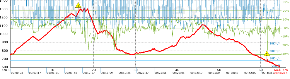
 Total length: 64.59 Km    mi / ft ?
 Analyzed distance: 64.59 Km
 Lineal distance: 16.38 Km
 Accumulated climb: 1361.1 m  info Points list
 Accumulated descent: 1504 m
 Maximum height: 1310.2 m
 Minimal height: 612.2 m
 Start height: 755 m
 End height : 612.2 m
 Climb rate: 4.79 %
 Descent rate: 5.43 %
 Positive climb difference per Km: 21.07 m
 Negative descent difference per Km: 23.29 m
 Max slope filter: ~30 %
 Min. points separation: ~30 m
 Number of points: 4088   (cad. 15.8 m)
 Significant points: 1810   (cad. 35.71 m / 44.28 %)
 Direction changes per Km: 10.99
 Direction changes >5º per Km: 7.97
 Accumulated straight stretches: 10.234 Km
 Straight stretches per Km: 158.45 m
 Penalizables slope changes: 11
 Penalizables slope changes per Km: 0.17
 Total time: 0:48:28 h
 Time in movement: 0:48:28 h
 Stopped time: 0:00:00 h
 Total speed average: 79.96 Km/h
 Average speed in movement : 79.96 Km/h
 Maximum held speed: 87.78 Km/h
Your fitness level
1


Altitude Slope % Speed Km/h Speed < 2 Km/h

Steep slopes > 5%

Steep slopes >5% Steep slopes >10% Steep slopes >15% Steep slopes >20% Steep slopes >25%
 Steep slope of 182 m.  Average slope  Interval  Download as waypoint
1
 km 0.634  6%  182 m
 Steep slope of 173 m.  Average slope  Interval  Download as waypoint
2
 km 0.925  8%  173 m
 Steep slope of 444 m.  Average slope  Interval  Download as waypoint
3
 km 1.207  7%  444 m
 Steep slope of 126 m.  Average slope  Interval  Download as waypoint
4
 km 2.358  5%  126 m
 Steep slope of 136 m.  Average slope  Interval  Download as waypoint
5
 km 2.908  6%  136 m
 Steep slope of 102 m.  Average slope  Interval  Download as waypoint
6
 km 3.733  5%  102 m
 Steep slope of 104 m.  Average slope  Interval  Download as waypoint
7
 km 4.769  5%  104 m
 Steep slope of 105 m.  Average slope  Interval  Download as waypoint
8
 km 5.162  5%  105 m
 Steep slope of 108 m.  Average slope  Interval  Download as waypoint
9
 km 7.974  7%  108 m
 Steep slope of 101 m.  Average slope  Interval  Download as waypoint
10
 km 8.615  5%  101 m
 Steep slope of 144 m.  Average slope  Interval  Download as waypoint
11
 km 8.827  5%  144 m
 Steep slope of 301 m.  Average slope  Interval  Download as waypoint
12
 km 9.771  5%  301 m
 Steep slope of 104 m.  Average slope  Interval  Download as waypoint
13
 km 10.221  6%  104 m
 Steep slope of 129 m.  Average slope  Interval  Download as waypoint
14
 km 11.615  6%  129 m
 Steep slope of 96 m.  Average slope  Interval  Download as waypoint
15
 km 11.843  6%  96 m
 Steep slope of 169 m.  Average slope  Interval  Download as waypoint
16
 km 12.049  6%  169 m
 Steep slope of 465 m.  Average slope  Interval  Download as waypoint
17
 km 12.753  7%  465 m
 Steep slope of 218 m.  Average slope  Interval  Download as waypoint
18
 km 13.68  6%  218 m
 Steep slope of 99 m.  Average slope  Interval  Download as waypoint
19
 km 14.233  5%  99 m
 Steep slope of 1062 m.  Average slope  Interval  Download as waypoint
20
 km 15.68  9%  607 m
21
 km 16.286  10%  138 m
22
 km 16.424  8%  317 m
 Steep slope of 376 m.  Average slope  Interval  Download as waypoint
23
 km 17.327  10%  34 m
24
 km 17.361  9%  134 m
25
 km 17.494  10%  208 m
 Steep slope of 402 m.  Average slope  Interval  Download as waypoint
26
 km 18.066  7%  402 m
 Steep slope of 345 m.  Average slope  Interval  Download as waypoint
27
 km 21.002  6%  345 m
 Steep slope of 101 m.  Average slope  Interval  Download as waypoint
28
 km 22.349  9%  101 m
 Steep slope of 178 m.  Average slope  Interval  Download as waypoint
29
 km 29.732  5%  178 m
 Steep slope of 159 m.  Average slope  Interval  Download as waypoint
30
 km 33.95  7%  159 m
 Steep slope of 116 m.  Average slope  Interval  Download as waypoint
31
 km 34.317  7%  116 m
 Steep slope of 170 m.  Average slope  Interval  Download as waypoint
32
 km 36.759  6%  170 m
 Steep slope of 182 m.  Average slope  Interval  Download as waypoint
33
 km 38.505  7%  182 m
 Steep slope of 1199 m.  Average slope  Interval  Download as waypoint
34
 km 39.679  8%  1199 m
 Steep slope of 143 m.  Average slope  Interval  Download as waypoint
35
 km 42.08  8%  143 m
 Steep slope of 203 m.  Average slope  Interval  Download as waypoint
36
 km 43.365  6%  203 m
 Steep slope of 538 m.  Average slope  Interval  Download as waypoint
37
 km 44.048  7%  538 m
 Steep slope of 145 m.  Average slope  Interval  Download as waypoint
38
 km 44.702  7%  145 m
 Steep slope of 141 m.  Average slope  Interval  Download as waypoint
39
 km 45.137  5%  141 m
 Steep slope of 484 m.  Average slope  Interval  Download as waypoint
40
 km 45.392  7%  484 m
 Steep slope of 117 m.  Average slope  Interval  Download as waypoint
41
 km 61.455  12%  117 m


Compare this trail with...
Select trails to compare from "My trails". 
demo_montnegrebtt_2013.trk Ref.: 36172170671632
demo_matagalls_montserrat.trk Ref.: 36172170846048
demo_marathon_madrid_2013.trk Ref.: 36172170699197
Compare


Download (Registered users)

  GPX (.gpx)
  Garmin Training Center (.tcx)
  CompeGPS (.trk)
  OziExplorer (.plt)
  Google Earth (.kml)
  PDF analysis


Remove track and analysis
Save this trail on "My trails"


Send this analysis to a friend (Registered users)
Message that will receive your friend:
Re:
Hi.
(your name) has considered that this analysis of a trail could be of your interest.

(he/she will see a link to this page)
E-mail of your friend
You can enter multiple addresses separated by commas
Text
 
Send to a friend