User: Password:   Login   Login with Facebook   Register

Send to a friend
   

Detailed analysis of the trail analyzed as Bicycle (BYC)
Trail difficulty
136
BYC
Track : aragon-zaragoza-rey-fernando-03-sos-rey-catolico-los-pintanos.gpx
These speeds are average for :  Drawn track (DRW)
Reanalyze as
HKG (Hiking) RNG (Running)
 Penalty trail's conditions: 81 %   ( > 50 % = MTB, < 50 % = RDB)
 Reliability of the original trail: DRW   (1570/64/0/-/-/64)
 Level of correction applied to the trail: 0
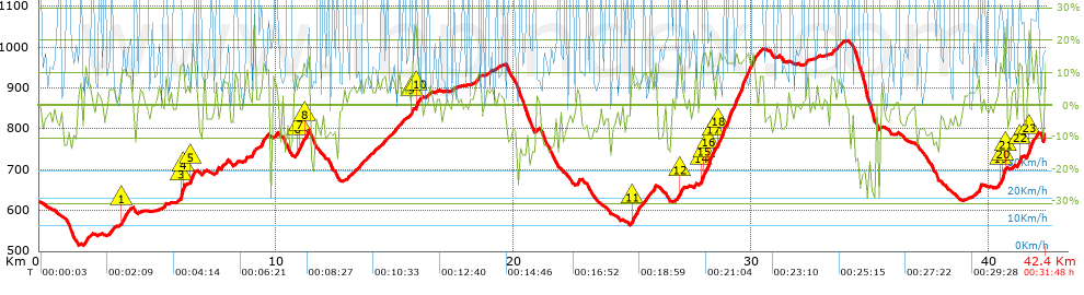
 Total length: 42.4 Km    mi / ft ?
 Analyzed distance: 42.4 Km
 Lineal distance: 16.56 Km
 Accumulated climb: 1559.44 m  info Points list
 Accumulated descent: 1390.84 m
 Maximum height: 1015.5 m
 Minimal height: 513.8 m
 Start height: 622.1 m
 End height : 785.6 m
 Climb rate: 7.55 %
 Descent rate: 8.09 %
 Positive climb difference per Km: 36.78 m
 Negative descent difference per Km: 32.8 m
 Max slope filter: ~30 %
 Min. points separation: ~30 m
 Number of points: 2666   (cad. 15.9 m)
 Significant points: 1168   (cad. 36.33 m / 43.81 %)
 Direction changes per Km: 11.42
 Direction changes >5º per Km: 8.3
 Accumulated straight stretches: 6.877 Km
 Straight stretches per Km: 162.19 m
 Penalizables slope changes: 15
 Penalizables slope changes per Km: 0.354
 Total time: 0:31:48 h
 Time in movement: 0:31:48 h
 Stopped time: 0:00:00 h
 Total speed average: 79.99 Km/h
 Average speed in movement : 80 Km/h
 Maximum held speed: 99.1 Km/h
Your fitness level
1


Altitude Slope % Speed Km/h Speed < 2 Km/h

Steep slopes > 5%

Steep slopes >5% Steep slopes >10% Steep slopes >15% Steep slopes >20% Steep slopes >25%
 Steep slope of 338 m.  Average slope  Interval  Download as waypoint
1
 km 1.893  8%  338 m
 Steep slope of 171 m.  Average slope  Interval  Download as waypoint
2
 km 2.963  8%  171 m
 Steep slope of 417 m.  Average slope  Interval  Download as waypoint
3
 km 3.445  9%  35 m
4
 km 3.479  11%  186 m
5
 km 3.666  9%  196 m
 Steep slope of 143 m.  Average slope  Interval  Download as waypoint
6
 km 5.203  5%  143 m
 Steep slope of 219 m.  Average slope  Interval  Download as waypoint
7
 km 5.923  13%  31 m
8
 km 5.955  19%  110 m
9
 km 6.065  15%  78 m
 Steep slope of 263 m.  Average slope  Interval  Download as waypoint
10
 km 6.245  5%  143 m
11
 km 6.389  13%  120 m
 Steep slope of 146 m.  Average slope  Interval  Download as waypoint
12
 km 6.903  8%  146 m
 Steep slope of 109 m.  Average slope  Interval  Download as waypoint
13
 km 7.422  15%  109 m
 Steep slope of 266 m.  Average slope  Interval  Download as waypoint
14
 km 7.698  8%  266 m
 Steep slope of 155 m.  Average slope  Interval  Download as waypoint
15
 km 8.207  9%  155 m
 Steep slope of 114 m.  Average slope  Interval  Download as waypoint
16
 km 8.616  6%  114 m
 Steep slope of 419 m.  Average slope  Interval  Download as waypoint
17
 km 9.285  5%  77 m
18
 km 9.361  9%  255 m
19
 km 9.616  11%  87 m
 Steep slope of 191 m.  Average slope  Interval  Download as waypoint
20
 km 9.815  6%  191 m
 Steep slope of 599 m.  Average slope  Interval  Download as waypoint
21
 km 10.723  8%  170 m
22
 km 10.894  11%  109 m
23
 km 11.003  10%  146 m
24
 km 11.149  12%  174 m
 Steep slope of 133 m.  Average slope  Interval  Download as waypoint
25
 km 12.973  7%  133 m
 Steep slope of 476 m.  Average slope  Interval  Download as waypoint
26
 km 13.245  6%  476 m
 Steep slope of 114 m.  Average slope  Interval  Download as waypoint
27
 km 13.832  6%  114 m
 Steep slope of 155 m.  Average slope  Interval  Download as waypoint
28
 km 14.057  5%  155 m
 Steep slope of 224 m.  Average slope  Interval  Download as waypoint
29
 km 14.392  7%  224 m
 Steep slope of 289 m.  Average slope  Interval  Download as waypoint
30
 km 14.711  6%  289 m
 Steep slope of 242 m.  Average slope  Interval  Download as waypoint
31
 km 15.103  7%  242 m
 Steep slope of 182 m.  Average slope  Interval  Download as waypoint
32
 km 15.559  5%  148 m
33
 km 15.706  12%  34 m
 Steep slope of 242 m.  Average slope  Interval  Download as waypoint
34
 km 15.823  25%  29 m
35
 km 15.852  15%  106 m
36
 km 15.958  8%  107 m
 Steep slope of 103 m.  Average slope  Interval  Download as waypoint
37
 km 16.298  6%  103 m
 Steep slope of 209 m.  Average slope  Interval  Download as waypoint
38
 km 18.336  7%  209 m
 Steep slope of 144 m.  Average slope  Interval  Download as waypoint
39
 km 22.633  9%  144 m
 Steep slope of 860 m.  Average slope  Interval  Download as waypoint
40
 km 24.888  8%  35 m
41
 km 24.924  11%  146 m
42
 km 25.07  8%  679 m
 Steep slope of 143 m.  Average slope  Interval  Download as waypoint
43
 km 25.865  10%  143 m
 Steep slope of 310 m.  Average slope  Interval  Download as waypoint
44
 km 26.831  8%  101 m
45
 km 26.932  15%  99 m
46
 km 27.03  8%  110 m
 Steep slope of 2669 m.  Average slope  Interval  Download as waypoint
47
 km 27.843  14%  67 m
48
 km 27.91  16%  98 m
49
 km 28.008  13%  189 m
50
 km 28.197  16%  156 m
51
 km 28.354  19%  37 m
52
 km 28.391  6%  148 m
53
 km 28.539  14%  1630 m
54
 km 30.169  5%  145 m
55
 km 30.314  8%  199 m
 Steep slope of 481 m.  Average slope  Interval  Download as waypoint
56
 km 33.339  6%  481 m
 Steep slope of 107 m.  Average slope  Interval  Download as waypoint
57
 km 39.524  18%  107 m
 Steep slope of 342 m.  Average slope  Interval  Download as waypoint
58
 km 40.404  11%  160 m
59
 km 40.563  22%  100 m
60
 km 40.663  18%  29 m
61
 km 40.692  6%  53 m
 Steep slope of 197 m.  Average slope  Interval  Download as waypoint
62
 km 41.233  13%  197 m
 Steep slope of 283 m.  Average slope  Interval  Download as waypoint
63
 km 41.605  8%  36 m
64
 km 41.64  17%  247 m
 Steep slope of 48 m.  Average slope  Interval  Download as waypoint
65
 km 41.935  17%  48 m


Compare this trail with...
Select trails to compare from "My trails". 
demo_montnegrebtt_2013.trk Ref.: 36172170671632
demo_matagalls_montserrat.trk Ref.: 36172170846048
demo_marathon_madrid_2013.trk Ref.: 36172170699197
Compare


Download (Registered users)

  GPX (.gpx)
  Garmin Training Center (.tcx)
  CompeGPS (.trk)
  OziExplorer (.plt)
  Google Earth (.kml)
  PDF analysis


Remove track and analysis
Save this trail on "My trails"


Send this analysis to a friend (Registered users)
Message that will receive your friend:
Re:
Hi.
(your name) has considered that this analysis of a trail could be of your interest.

(he/she will see a link to this page)
E-mail of your friend
You can enter multiple addresses separated by commas
Text
 
Send to a friend