Trail difficulty
87
RNG
|
| Track : v_v_ojos_negros_01.gpx |
|
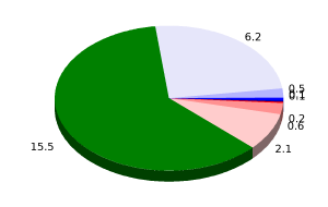
These speeds are average for : BYC
(Bicycle) Reanalyze as BYC (Bicycle) HKG (Hiking) |
|
|
| Level of correction applied to the trail: 0 |
| Total length: 25.34 Km mi / ft ? |
| Analyzed distance: 25.34 Km |
| Lineal distance: 18.67 Km |
| Accumulated climb: 100.9 m |
 info Points list info Points list |
| Accumulated descent: 170.6 m | |
| Maximum height: 1012.8 m | |
| Minimal height: 901.6 m | |
| Start height: 1012.8 m | |
| End height : 919.4 m | |
| Climb rate: 3.45 % | |
| Descent rate: 2.48 % | |
| Positive climb difference per Km: 3.98 m | |
| Negative descent difference per Km: 6.73 m | |
| Max slope filter: ~55 % |
| Min. points separation: ~30 m |
| Number of points: 545 (cad. 46.5 m) |
| Significant points: 383 (cad. 66.34 m / 70.28 %) |
| Direction changes per Km: 6.67 |
| Direction changes >5ş per Km: 2.33 |
| Accumulated straight stretches: 12.952 Km |
| Straight stretches per Km: 511.13 m |
| Penalizables slope changes: 0 |
| Penalizables slope changes per Km: 0 |
| Total time: 2:20:17 h |
| Time in movement: 2:15:32 h |
| Stopped time: 0:04:45 h |
| Total speed average: 10.84 Km/h |
| Average speed in movement : 11.22 Km/h |
| Maximum held speed: 35.89 Km/h |
 |
|
|
Remove track and analysis |
|
|
Save this trail on "My trails" |