User: Password:   Login   Login with Facebook   Register

Send to a friend
   

Detailed analysis of the trail analyzed as Hiking (HKG)
Trail difficulty
185
HKG
Track : completa-cantabria-menhires-mataporquera-pena-labra.gpx
These speeds are average for : HKG (Hiking)
Reanalyze as
BYC (Bicycle) RNG (Running)
 Reliability of the original trail: D   (2538/37/1/2/-/76)
 Level of correction applied to the trail: 5        See original analysis (without corrections)
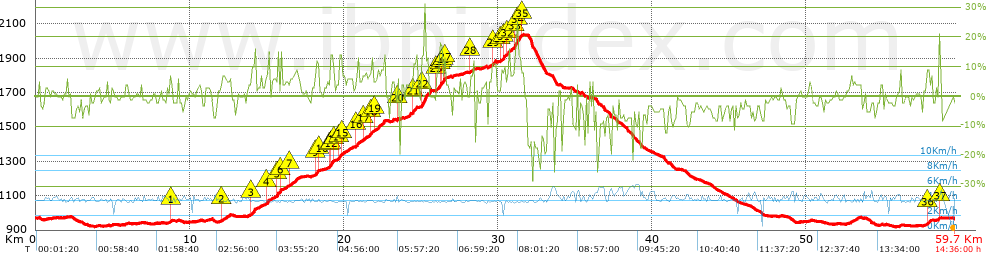
 Total length: 58.88 Km    mi / ft ?
 Analyzed distance: 58.88 Km
 Lineal distance: 0 Km
 Accumulated climb: 1448.73 m  info Points list
 Accumulated descent: 1453.24 m
 Maximum height: 2039.71 m
 Minimal height: 918.96 m
 Start height: 970.1 m
 End height : 967 m
 Climb rate: 6.01 %
 Descent rate: 5.82 %
 Positive climb difference per Km: 24.6 m
 Negative descent difference per Km: 24.68 m
 Max slope filter: ~55 %
 Min. points separation: ~30 m
 Number of points: 2597   (cad. 22.67 m)
 Significant points: 1342   (cad. 44.04 m / 51.68 %)
 Direction changes per Km: 8.8
 Direction changes >5º per Km: 5.03
 Accumulated straight stretches: 17.902 Km
 Straight stretches per Km: 304.04 m
 Penalizables slope changes: 8
 Penalizables slope changes per Km: 0.136
 Total time: 14:36:00 h
 Time in movement: 14:33:00 h
 Stopped time: 0:03:00 h
 Total speed average: 4.03 Km/h
 Average speed in movement : 4.05 Km/h
 Maximum held speed: 6.3 Km/h


Altitude Slope % Speed Km/h Speed < 0.5 Km/h

Steep slopes > 5%

Steep slopes >5% Steep slopes >10% Steep slopes >15% Steep slopes >20% Steep slopes >25%
 Steep slope of 133 m.  Average slope  Interval  Download as waypoint
1
 km 8.715  7%  133 m
 Steep slope of 576 m.  Average slope  Interval  Download as waypoint
2
 km 12.092  6%  576 m
 Steep slope of 346 m.  Average slope  Interval  Download as waypoint
3
 km 13.98  11%  346 m
 Steep slope of 605 m.  Average slope  Interval  Download as waypoint
4
 km 14.926  7%  605 m
 Steep slope of 255 m.  Average slope  Interval  Download as waypoint
5
 km 15.658  11%  211 m
6
 km 15.869  16%  44 m
 Steep slope of 641 m.  Average slope  Interval  Download as waypoint
7
 km 16.469  7%  641 m
 Steep slope of 301 m.  Average slope  Interval  Download as waypoint
8
 km 18.13  7%  42 m
9
 km 18.172  11%  216 m
10
 km 18.388  7%  43 m
 Steep slope of 297 m.  Average slope  Interval  Download as waypoint
11
 km 19.068  9%  43 m
12
 km 19.112  14%  212 m
13
 km 19.324  9%  42 m
 Steep slope of 854 m.  Average slope  Interval  Download as waypoint
14
 km 19.7  13%  171 m
15
 km 19.871  6%  683 m
 Steep slope of 297 m.  Average slope  Interval  Download as waypoint
16
 km 20.765  8%  297 m
 Steep slope of 1450 m.  Average slope  Interval  Download as waypoint
17
 km 21.233  7%  556 m
18
 km 21.789  12%  131 m
19
 km 21.919  8%  763 m
 Steep slope of 177 m.  Average slope  Interval  Download as waypoint
20
 km 23.468  9%  177 m
 Steep slope of 254 m.  Average slope  Interval  Download as waypoint
21
 km 24.46  12%  254 m
 Steep slope of 595 m.  Average slope  Interval  Download as waypoint
22
 km 25.009  15%  595 m
 Steep slope of 667 m.  Average slope  Interval  Download as waypoint
23
 km 25.98  8%  250 m
24
 km 26.231  18%  124 m
25
 km 26.355  7%  127 m
26
 km 26.482  17%  125 m
27
 km 26.606  6%  41 m
 Steep slope of 347 m.  Average slope  Interval  Download as waypoint
28
 km 28.179  8%  347 m
 Steep slope of 256 m.  Average slope  Interval  Download as waypoint
29
 km 29.63  11%  256 m
 Steep slope of 1424 m.  Average slope  Interval  Download as waypoint
30
 km 30.185  8%  168 m
31
 km 30.353  12%  167 m
32
 km 30.52  8%  587 m
33
 km 31.107  20%  167 m
34
 km 31.274  13%  248 m
35
 km 31.522  8%  87 m
 Steep slope of 177 m.  Average slope  Interval  Download as waypoint
36
 km 57.827  10%  177 m
 Steep slope of 136 m.  Average slope  Interval  Download as waypoint
37
 km 58.618  10%  136 m


Compare this trail with...
Select trails to compare from "My trails". 
demo_montnegrebtt_2013.trk Ref.: 36172170671632
demo_matagalls_montserrat.trk Ref.: 36172170846048
demo_marathon_madrid_2013.trk Ref.: 36172170699197
Compare


Download (Registered users)

  GPX (.gpx)
  Garmin Training Center (.tcx)
  CompeGPS (.trk)
  OziExplorer (.plt)
  Google Earth (.kml)
  PDF analysis


Remove track and analysis
Save this trail on "My trails"


Send this analysis to a friend (Registered users)
Message that will receive your friend:
Re:
Hi.
(your name) has considered that this analysis of a trail could be of your interest.

(he/she will see a link to this page)
E-mail of your friend
You can enter multiple addresses separated by commas
Text
 
Send to a friend