Trail difficulty
14
HKG
|
| Track : acceso_peonera.gpx |
|
These speeds are average for : HKG
(Hiking) Reanalyze as BYC (Bicycle) RNG (Running) |
|
|
Level of correction applied to the trail:
4
 See original analysis (without corrections) See original analysis (without corrections)
|
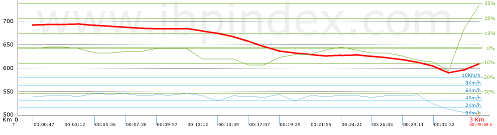
| Total length: 2.96 Km mi / ft ? |
| Analyzed distance: 2.96 Km |
| Lineal distance: 1.57 Km |
| Accumulated climb: 22.73 m |
info Points list |
| Accumulated descent: 108.85 m | |
| Maximum height: 694.01 m | |
| Minimal height: 587.56 m | |
| Start height: 692.2 m | |
| End height : 608.67 m | |
| Climb rate: 8.18 % | |
| Descent rate: 5.37 % | |
| Positive climb difference per Km: 7.68 m | |
| Negative descent difference per Km: 36.77 m | |
| Max slope filter: ~55 % |
| Min. points separation: ~30 m |
| Number of points: 256 (cad. 11.55 m) |
| Significant points: 87 (cad. 34.38 m / 33.98 %) |
| Direction changes per Km: 13.51 |
| Direction changes >5ş per Km: 10.81 |
| Accumulated straight stretches: 0.312 Km |
| Straight stretches per Km: 105.41 m |
| Penalizables slope changes: 0 |
| Penalizables slope changes per Km: 0 |
| Total time: 0:49:08 h |
| Time in movement: 0:40:50 h |
| Stopped time: 0:08:18 h |
| Total speed average: 3.61 Km/h |
| Average speed in movement : 4.35 Km/h |
| Maximum held speed: 6.07 Km/h |
 |
|
|
Remove track and analysis |
|
|
Save this trail on "My trails" |