Trail difficulty
46
HKG
|
| Track : acceso_masc_n.gpx |
|
These speeds are average for : HKG
(Hiking) Reanalyze as BYC (Bicycle) RNG (Running) |
|
|
| Level of correction applied to the trail: 0 |
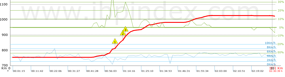
| Total length: 10.08 Km mi / ft ? |
| Analyzed distance: 10.08 Km |
| Lineal distance: 5.71 Km |
| Accumulated climb: 273 m |
 info Points list info Points list |
| Accumulated descent: 4 m | |
| Maximum height: 1027 m | |
| Minimal height: 754 m | |
| Start height: 754 m | |
| End height : 1023 m | |
| Climb rate: 9.47 % | |
| Descent rate: 3.87 % | |
| Positive climb difference per Km: 27.08 m | |
| Negative descent difference per Km: 0.4 m | |
| Max slope filter: ~55 % |
| Min. points separation: ~30 m |
| Number of points: 876 (cad. 11.51 m) |
| Significant points: 294 (cad. 34.41 m / 33.56 %) |
| Direction changes per Km: 13.99 |
| Direction changes >5ş per Km: 12.8 |
| Accumulated straight stretches: 0.832 Km |
| Straight stretches per Km: 82.54 m |
| Penalizables slope changes: 2 |
| Penalizables slope changes per Km: 0.198 |
| Total time: 2:30:39 h |
| Time in movement: 2:26:38 h |
| Stopped time: 0:04:01 h |
| Total speed average: 4.02 Km/h |
| Average speed in movement : 4.12 Km/h |
| Maximum held speed: 7.93 Km/h |
 |
|
|
Remove track and analysis |
|
|
Save this trail on "My trails" |