Trail difficulty
169
BYC
|
| Track : ruta.gpx |
|
These speeds are average for : HKG
(Hiking) Reanalyze as HKG (Hiking) RNG (Running) |
| Penalty trail's conditions: 65 % ( > 50 % = MTB, < 50 % = RDB) |
|
|
| Level of correction applied to the trail: 0 |
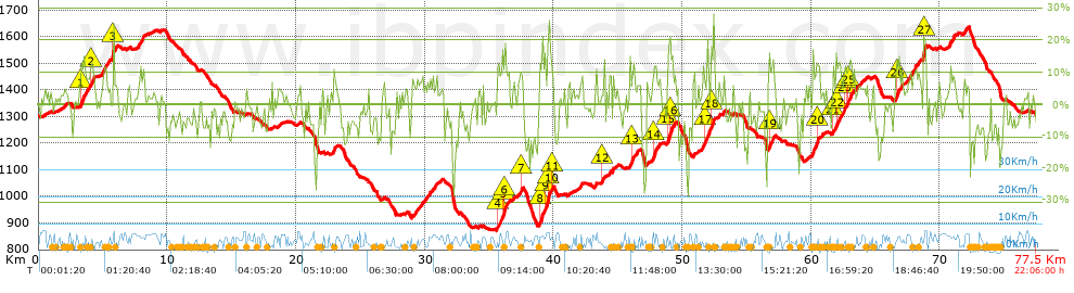
| Total length: 77.55 Km mi / ft ? |
| Analyzed distance: 77.55 Km |
| Lineal distance: 0.01 Km |
| Accumulated climb: 2285.62 m |
 info Points list info Points list |
| Accumulated descent: 2290.2 m | |
| Maximum height: 1636.9 m | |
| Minimal height: 871.5 m | |
| Start height: 1306.1 m | |
| End height : 1305.7 m | |
| Climb rate: 6.57 % | |
| Descent rate: 7.06 % | |
| Positive climb difference per Km: 29.47 m | |
| Negative descent difference per Km: 29.53 m | |
| Max slope filter: ~30 % |
| Min. points separation: ~30 m |
| Number of points: 1731 (cad. 44.8 m) |
| Significant points: 1356 (cad. 57.23 m / 78.34 %) |
| Direction changes per Km: 7.57 |
| Direction changes >5ş per Km: 6.41 |
| Accumulated straight stretches: 16.548 Km |
| Straight stretches per Km: 213.38 m |
| Penalizables slope changes: 26 |
| Penalizables slope changes per Km: 0.335 |
| Total time: 22:06:00 h |
| Time in movement: 18:52:40 h |
| Stopped time: 3:13:20 h |
| Total speed average: 3.51 Km/h |
| Average speed in movement : 4.11 Km/h |
| Maximum held speed: 8.98 Km/h |
Your fitness level
100
|
 |
|
|
Remove track and analysis |
|
|
Save this trail on "My trails" |