User: Password:   Login   Login with Facebook   Register

Send to a friend
   

Detailed analysis of the trail analyzed as Bicycle (BYC)
Trail difficulty
780
BYC
Track : global_express.gpx
These speeds are average for : BYC (Bicycle)
Reanalyze as
HKG (Hiking) RNG (Running)
 Penalty trail's conditions: 20 %   ( > 50 % = MTB, < 50 % = RDB)
 Reliability of the original trail: A   (7881/72/0/-/-/72)
 Level of correction applied to the trail: 0
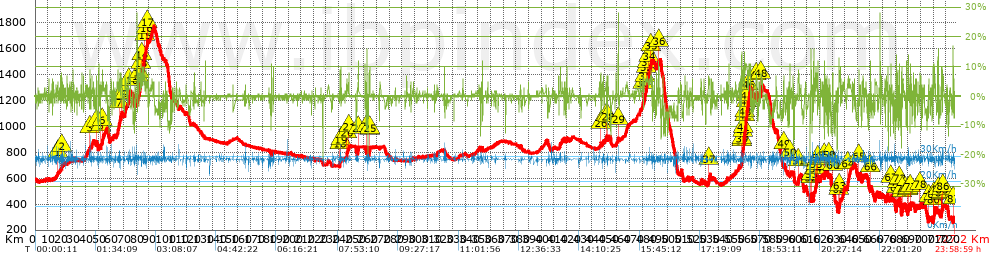
 Total length: 727.18 Km    mi / ft ?
 Analyzed distance: 727.18 Km
 Lineal distance: 490.01 Km
 Accumulated climb: 7880.5 m  info Points list
 Accumulated descent: 8107.9 m
 Maximum height: 1769.5 m
 Minimal height: 256.6 m
 Start height: 593.5 m
 End height : 266.5 m
 Climb rate: 3.88 %
 Descent rate: 4.03 %
 Positive climb difference per Km: 10.84 m
 Negative descent difference per Km: 11.15 m
 Max slope filter: ~30 %
 Min. points separation: ~30 m
 Number of points: 5879   (cad. 123.69 m)
 Significant points: 5340   (cad. 136.2 m / 90.83 %)
 Direction changes per Km: 3.54
 Direction changes >5º per Km: 3.07
 Accumulated straight stretches: 87.197 Km
 Straight stretches per Km: 119.91 m
 Penalizables slope changes: 82
 Penalizables slope changes per Km: 0.113
 Total time: 23:58:59 h
 Time in movement: 23:58:59 h
 Stopped time: 0:00:00 h
 Total speed average: 30.32 Km/h
 Average speed in movement : 30.32 Km/h
 Maximum held speed: 34.16 Km/h
Your fitness level
?*
* fit = ? Not enought comparison elements or invalid track


Altitude Slope % Speed Km/h Speed < 2 Km/h

Steep slopes > 5%

Steep slopes >5% Steep slopes >10% Steep slopes >15% Steep slopes >20% Steep slopes >25%
 Steep slope of 150 m.  Average slope  Interval  Download as waypoint
1
 km 17.871  6%  150 m
 Steep slope of 267 m.  Average slope  Interval  Download as waypoint
2
 km 20.941  7%  267 m
 Steep slope of 177 m.  Average slope  Interval  Download as waypoint
3
 km 43.171  5%  177 m
 Steep slope of 302 m.  Average slope  Interval  Download as waypoint
4
 km 48.495  7%  302 m
 Steep slope of 123 m.  Average slope  Interval  Download as waypoint
5
 km 51.97  8%  123 m
 Steep slope of 394 m.  Average slope  Interval  Download as waypoint
6
 km 53.062  6%  394 m
 Steep slope of 599 m.  Average slope  Interval  Download as waypoint
7
 km 66.682  6%  599 m
 Steep slope of 593 m.  Average slope  Interval  Download as waypoint
8
 km 67.868  6%  593 m
 Steep slope of 1167 m.  Average slope  Interval  Download as waypoint
9
 km 70.857  6%  1167 m
 Steep slope of 1243 m.  Average slope  Interval  Download as waypoint
10
 km 74.054  6%  1243 m
 Steep slope of 293 m.  Average slope  Interval  Download as waypoint
11
 km 81.519  5%  293 m
 Steep slope of 962 m.  Average slope  Interval  Download as waypoint
12
 km 82.246  7%  962 m
 Steep slope of 590 m.  Average slope  Interval  Download as waypoint
13
 km 83.518  8%  590 m
 Steep slope of 1962 m.  Average slope  Interval  Download as waypoint
14
 km 84.393  7%  1962 m
 Steep slope of 269 m.  Average slope  Interval  Download as waypoint
15
 km 86.504  6%  269 m
 Steep slope of 197 m.  Average slope  Interval  Download as waypoint
16
 km 87.701  7%  197 m
 Steep slope of 492 m.  Average slope  Interval  Download as waypoint
17
 km 88.867  5%  492 m
 Steep slope of 453 m.  Average slope  Interval  Download as waypoint
18
 km 240.882  8%  453 m
 Steep slope of 230 m.  Average slope  Interval  Download as waypoint
19
 km 241.483  8%  230 m
 Steep slope of 413 m.  Average slope  Interval  Download as waypoint
20
 km 246.31  7%  413 m
 Steep slope of 241 m.  Average slope  Interval  Download as waypoint
21
 km 247.889  5%  241 m
 Steep slope of 464 m.  Average slope  Interval  Download as waypoint
22
 km 255.338  8%  464 m
 Steep slope of 348 m.  Average slope  Interval  Download as waypoint
23
 km 262.14  13%  348 m
 Steep slope of 485 m.  Average slope  Interval  Download as waypoint
24
 km 264.295  8%  180 m
25
 km 264.475  11%  305 m
 Steep slope of 408 m.  Average slope  Interval  Download as waypoint
26
 km 446.922  8%  408 m
 Steep slope of 365 m.  Average slope  Interval  Download as waypoint
27
 km 451.246  5%  365 m
 Steep slope of 393 m.  Average slope  Interval  Download as waypoint
28
 km 452.689  7%  393 m
 Steep slope of 141 m.  Average slope  Interval  Download as waypoint
29
 km 460.988  18%  141 m
 Steep slope of 391 m.  Average slope  Interval  Download as waypoint
30
 km 480.435  7%  391 m
 Steep slope of 511 m.  Average slope  Interval  Download as waypoint
31
 km 481.908  6%  511 m
 Steep slope of 487 m.  Average slope  Interval  Download as waypoint
32
 km 483.2  5%  487 m
 Steep slope of 489 m.  Average slope  Interval  Download as waypoint
33
 km 483.978  6%  489 m
 Steep slope of 931 m.  Average slope  Interval  Download as waypoint
34
 km 484.935  5%  931 m
 Steep slope of 671 m.  Average slope  Interval  Download as waypoint
35
 km 486.378  7%  671 m
 Steep slope of 204 m.  Average slope  Interval  Download as waypoint
36
 km 492.857  10%  204 m
 Steep slope of 867 m.  Average slope  Interval  Download as waypoint
37
 km 532.374  6%  867 m
 Steep slope of 641 m.  Average slope  Interval  Download as waypoint
38
 km 558.404  11%  217 m
39
 km 558.621  10%  424 m
 Steep slope of 471 m.  Average slope  Interval  Download as waypoint
40
 km 559.176  8%  471 m
 Steep slope of 3033 m.  Average slope  Interval  Download as waypoint
41
 km 559.822  7%  844 m
42
 km 560.666  12%  404 m
43
 km 561.07  9%  308 m
44
 km 561.378  11%  1003 m
45
 km 562.382  10%  474 m
 Steep slope of 1834 m.  Average slope  Interval  Download as waypoint
46
 km 563.439  8%  1834 m
 Steep slope of 476 m.  Average slope  Interval  Download as waypoint
47
 km 570.016  6%  476 m
 Steep slope of 715 m.  Average slope  Interval  Download as waypoint
48
 km 573.62  7%  715 m
 Steep slope of 203 m.  Average slope  Interval  Download as waypoint
49
 km 591.839  6%  203 m
 Steep slope of 212 m.  Average slope  Interval  Download as waypoint
50
 km 596.622  9%  212 m
 Steep slope of 569 m.  Average slope  Interval  Download as waypoint
51
 km 603.11  7%  569 m
 Steep slope of 448 m.  Average slope  Interval  Download as waypoint
52
 km 613.176  13%  165 m
53
 km 613.341  5%  283 m
 Steep slope of 364 m.  Average slope  Interval  Download as waypoint
54
 km 616.596  6%  364 m
 Steep slope of 262 m.  Average slope  Interval  Download as waypoint
55
 km 617.22  5%  262 m
 Steep slope of 294 m.  Average slope  Interval  Download as waypoint
56
 km 617.977  6%  294 m
 Steep slope of 398 m.  Average slope  Interval  Download as waypoint
57
 km 618.597  7%  398 m
 Steep slope of 471 m.  Average slope  Interval  Download as waypoint
58
 km 623.925  8%  471 m
 Steep slope of 183 m.  Average slope  Interval  Download as waypoint
59
 km 627.452  8%  183 m
 Steep slope of 254 m.  Average slope  Interval  Download as waypoint
60
 km 630.326  8%  254 m
 Steep slope of 952 m.  Average slope  Interval  Download as waypoint
61
 km 635.326  8%  67 m
62
 km 635.393  11%  223 m
63
 km 635.615  7%  662 m
 Steep slope of 773 m.  Average slope  Interval  Download as waypoint
64
 km 642.274  6%  773 m
 Steep slope of 305 m.  Average slope  Interval  Download as waypoint
65
 km 651.14  8%  305 m
 Steep slope of 288 m.  Average slope  Interval  Download as waypoint
66
 km 660.275  9%  288 m
 Steep slope of 398 m.  Average slope  Interval  Download as waypoint
67
 km 676.342  9%  398 m
 Steep slope of 457 m.  Average slope  Interval  Download as waypoint
68
 km 680.626  6%  66 m
69
 km 680.692  13%  391 m
 Steep slope of 534 m.  Average slope  Interval  Download as waypoint
70
 km 681.444  7%  534 m
 Steep slope of 342 m.  Average slope  Interval  Download as waypoint
71
 km 683.038  7%  110 m
72
 km 683.148  11%  232 m
 Steep slope of 343 m.  Average slope  Interval  Download as waypoint
73
 km 685.027  9%  343 m
 Steep slope of 229 m.  Average slope  Interval  Download as waypoint
74
 km 685.552  7%  229 m
 Steep slope of 173 m.  Average slope  Interval  Download as waypoint
75
 km 689.904  11%  173 m
 Steep slope of 322 m.  Average slope  Interval  Download as waypoint
76
 km 690.294  9%  322 m
 Steep slope of 558 m.  Average slope  Interval  Download as waypoint
77
 km 691.864  7%  558 m
 Steep slope of 288 m.  Average slope  Interval  Download as waypoint
78
 km 699.344  6%  288 m
 Steep slope of 245 m.  Average slope  Interval  Download as waypoint
79
 km 706.531  5%  245 m
 Steep slope of 463 m.  Average slope  Interval  Download as waypoint
80
 km 709.926  8%  463 m
 Steep slope of 788 m.  Average slope  Interval  Download as waypoint
81
 km 710.578  7%  788 m
 Steep slope of 202 m.  Average slope  Interval  Download as waypoint
82
 km 713.847  10%  202 m
 Steep slope of 235 m.  Average slope  Interval  Download as waypoint
83
 km 716.304  8%  68 m
84
 km 716.372  12%  167 m
 Steep slope of 386 m.  Average slope  Interval  Download as waypoint
85
 km 716.738  6%  386 m
 Steep slope of 140 m.  Average slope  Interval  Download as waypoint
86
 km 717.405  8%  140 m
 Steep slope of 300 m.  Average slope  Interval  Download as waypoint
87
 km 725.557  11%  300 m


Compare this trail with...
Select trails to compare from "My trails". 
demo_montnegrebtt_2013.trk Ref.: 36172170671632
demo_matagalls_montserrat.trk Ref.: 36172170846048
demo_marathon_madrid_2013.trk Ref.: 36172170699197
Compare


Download (Registered users)

  GPX (.gpx)
  Garmin Training Center (.tcx)
  CompeGPS (.trk)
  OziExplorer (.plt)
  Google Earth (.kml)
  PDF analysis


Remove track and analysis
Save this trail on "My trails"


Send this analysis to a friend (Registered users)
Message that will receive your friend:
Re:
Hi.
(your name) has considered that this analysis of a trail could be of your interest.

(he/she will see a link to this page)
E-mail of your friend
You can enter multiple addresses separated by commas
Text
 
Send to a friend