Trail difficulty
286
RNG
|
| Track : madrid_-_06_etapa_del_camino_de_santiago_desde_el_burgo_ranero_hacia_astorga.gpx |
|
These speeds are average for : BYC
(Bicycle) Reanalyze as BYC (Bicycle) HKG (Hiking) |
|
|
Level of correction applied to the trail:
6
 See original analysis (without corrections) See original analysis (without corrections)
|
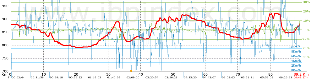
| Total length: 89.15 Km mi / ft ? |
| Analyzed distance: 89.15 Km |
| Lineal distance: 69.54 Km |
| Accumulated climb: 418.32 m |
info Points list |
| Accumulated descent: 398.08 m | |
| Maximum height: 921.58 m | |
| Minimal height: 790.91 m | |
| Start height: 879.7 m | |
| End height : 882.5 m | |
| Climb rate: 2.79 % | |
| Descent rate: 2.77 % | |
| Positive climb difference per Km: 4.69 m | |
| Negative descent difference per Km: 4.47 m | |
| Max slope filter: ~55 % |
| Min. points separation: ~30 m |
| Number of points: 3076 (cad. 28.98 m) |
| Significant points: 1996 (cad. 44.69 m / 64.89 %) |
| Direction changes per Km: 9.22 |
| Direction changes >5ş per Km: 2.56 |
| Accumulated straight stretches: 56.224 Km |
| Straight stretches per Km: 630.67 m |
| Penalizables slope changes: 6 |
| Penalizables slope changes per Km: 0.067 |
| Total time: 6:49:57 h |
| Time in movement: 6:02:58 h |
| Stopped time: 0:46:59 h |
| Total speed average: 13.05 Km/h |
| Average speed in movement : 14.74 Km/h |
| Maximum held speed: 51.14 Km/h |
 |
|
|
Remove track and analysis |
|
|
Save this trail on "My trails" |