Trail difficulty
63
BYC
|
| Track : madrid_-_09_del_camino_de_santiago_desde_sarria_a_o_coto.gpx |
|
These speeds are average for : BYC
(Bicycle) Reanalyze as HKG (Hiking) RNG (Running) |
| Penalty trail's conditions: 36 % ( > 50 % = MTB, < 50 % = RDB) |
|
|
| Level of correction applied to the trail: 0 |
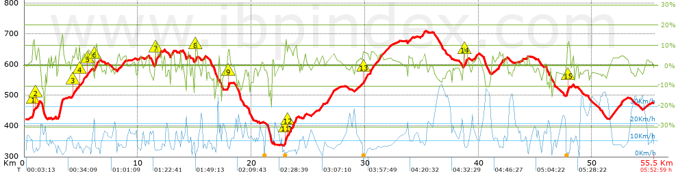
| Total length: 55.47 Km mi / ft ? |
| Analyzed distance: 55.47 Km |
| Lineal distance: 45.73 Km |
| Accumulated climb: 1149.2 m |
 info Points list info Points list |
| Accumulated descent: 1094.2 m | |
| Maximum height: 708.1 m | |
| Minimal height: 336.5 m | |
| Start height: 422.6 m | |
| End height : 473.7 m | |
| Climb rate: 4.55 % | |
| Descent rate: 4.91 % | |
| Positive climb difference per Km: 20.72 m | |
| Negative descent difference per Km: 19.73 m | |
| Max slope filter: ~30 % |
| Min. points separation: ~30 m |
| Number of points: 609 (cad. 91.08 m) |
| Significant points: 544 (cad. 102.15 m / 89.33 %) |
| Direction changes per Km: 5.28 |
| Direction changes >5ş per Km: 4.78 |
| Accumulated straight stretches: 4.341 Km |
| Straight stretches per Km: 78.26 m |
| Penalizables slope changes: 9 |
| Penalizables slope changes per Km: 0.162 |
| Total time: 5:52:59 h |
| Time in movement: 5:17:08 h |
| Stopped time: 0:35:51 h |
| Total speed average: 9.43 Km/h |
| Average speed in movement : 10.49 Km/h |
| Maximum held speed: 44.68 Km/h |
Your fitness level
97
|
 |
|
|
Remove track and analysis |
|
|
Save this trail on "My trails" |