User: Password:   Login   Login with Facebook   Register

Send to a friend
   

Detailed analysis of the trail analyzed as Hiking (HKG)
Trail difficulty
84
HKG
Track : circular-foradadapenya-rojaalt-del-xapxarpolarbenissiliriu-d_1.gpx
These speeds are average for : HKG (Hiking)
Reanalyze as
BYC (Bicycle) RNG (Running)
 Reliability of the original trail: D   (1169/47/1/4/-/76)
 Level of correction applied to the trail: 3        See original analysis (without corrections)
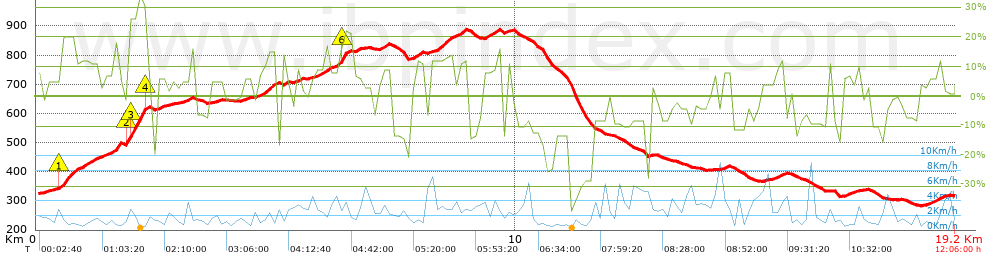
 Total length: 19.06 Km    mi / ft ?
 Analyzed distance: 19.06 Km
 Lineal distance: 0 Km
 Accumulated climb: 894.36 m  info Points list
 Accumulated descent: 887.94 m
 Maximum height: 888.32 m
 Minimal height: 281.88 m
 Start height: 318.7 m
 End height : 318.8 m
 Climb rate: 9.33 %
 Descent rate: 9.87 %
 Positive climb difference per Km: 46.92 m
 Negative descent difference per Km: 46.59 m
 Max slope filter: ~55 %
 Min. points separation: ~30 m
 Number of points: 861   (cad. 22.14 m)
 Significant points: 448   (cad. 43.13 m / 52.03 %)
 Direction changes per Km: 12.07
 Direction changes >5º per Km: 10.07
 Accumulated straight stretches: 1.328 Km
 Straight stretches per Km: 69.67 m
 Penalizables slope changes: 7
 Penalizables slope changes per Km: 0.367
 Total time: 12:06:00 h
 Time in movement: 9:50:40 h
 Stopped time: 2:15:20 h
 Total speed average: 1.58 Km/h
 Average speed in movement : 1.94 Km/h
 Maximum held speed: 7.06 Km/h


Altitude Slope % Speed Km/h Speed < 0.5 Km/h

Steep slopes > 5%

Steep slopes >5% Steep slopes >10% Steep slopes >15% Steep slopes >20% Steep slopes >25%
 Steep slope of 814 m.  Average slope  Interval  Download as waypoint
1
 km 0  5%  480 m
2
 km 0.48  19%  304 m
3
 km 0.784  10%  30 m
 Steep slope of 736 m.  Average slope  Interval  Download as waypoint
4
 km 0.945  12%  41 m
5
 km 0.986  10%  155 m
6
 km 1.142  11%  166 m
7
 km 1.308  7%  374 m
 Steep slope of 454 m.  Average slope  Interval  Download as waypoint
8
 km 1.853  25%  43 m
9
 km 1.896  29%  381 m
10
 km 2.277  15%  30 m
 Steep slope of 315 m.  Average slope  Interval  Download as waypoint
11
 km 2.471  5%  315 m
 Steep slope of 700 m.  Average slope  Interval  Download as waypoint
12
 km 4.261  5%  476 m
13
 km 4.737  14%  224 m
 Steep slope of 115 m.  Average slope  Interval  Download as waypoint
14
 km 5.42  9%  115 m
 Steep slope of 809 m.  Average slope  Interval  Download as waypoint
15
 km 5.744  9%  576 m
16
 km 6.32  16%  58 m
17
 km 6.378  22%  175 m
 Steep slope of 210 m.  Average slope  Interval  Download as waypoint
18
 km 7.17  9%  210 m
 Steep slope of 104 m.  Average slope  Interval  Download as waypoint
19
 km 7.906  12%  104 m
 Steep slope of 616 m.  Average slope  Interval  Download as waypoint
20
 km 8.247  11%  616 m
 Steep slope of 362 m.  Average slope  Interval  Download as waypoint
21
 km 9.318  10%  362 m
 Steep slope of 208 m.  Average slope  Interval  Download as waypoint
22
 km 15.422  9%  52 m
23
 km 15.474  12%  156 m
 Steep slope of 332 m.  Average slope  Interval  Download as waypoint
24
 km 16.819  6%  332 m
 Steep slope of 470 m.  Average slope  Interval  Download as waypoint
25
 km 18.592  7%  470 m


Compare this trail with...
Select trails to compare from "My trails". 
demo_montnegrebtt_2013.trk Ref.: 36172170671632
demo_matagalls_montserrat.trk Ref.: 36172170846048
demo_marathon_madrid_2013.trk Ref.: 36172170699197
Compare


Download (Registered users)

  GPX (.gpx)
  Garmin Training Center (.tcx)
  CompeGPS (.trk)
  OziExplorer (.plt)
  Google Earth (.kml)
  PDF analysis


Remove track and analysis
Save this trail on "My trails"


Send this analysis to a friend (Registered users)
Message that will receive your friend:
Re:
Hi.
(your name) has considered that this analysis of a trail could be of your interest.

(he/she will see a link to this page)
E-mail of your friend
You can enter multiple addresses separated by commas
Text
 
Send to a friend