Trail difficulty
53
HKG
|
| Track : -ruta-covaltacreuv-g-covalta-casa-forestal-dalbaida-ibp-53-h.gpx |
|
These speeds are average for : HKG
(Hiking) Reanalyze as BYC (Bicycle) RNG (Running) |
|
|
| Level of correction applied to the trail: 0 |
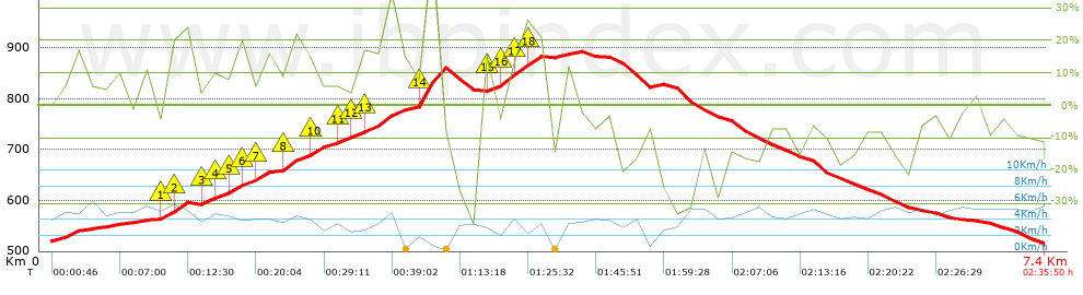
| Total length: 7.38 Km mi / ft ? |
| Analyzed distance: 7.38 Km |
| Lineal distance: 0.02 Km |
| Accumulated climb: 473.38 m |
 info Points list info Points list |
| Accumulated descent: 477.68 m | |
| Maximum height: 892.7 m | |
| Minimal height: 515.4 m | |
| Start height: 520.2 m | |
| End height : 515.4 m | |
| Climb rate: 14.3 % | |
| Descent rate: 12.35 % | |
| Positive climb difference per Km: 64.14 m | |
| Negative descent difference per Km: 64.73 m | |
| Max slope filter: ~55 % |
| Min. points separation: ~30 m |
| Number of points: 665 (cad. 11.09 m) |
| Significant points: 219 (cad. 33.83 m / 32.93 %) |
| Direction changes per Km: 13.55 |
| Direction changes >5ş per Km: 11.38 |
| Accumulated straight stretches: 0.684 Km |
| Straight stretches per Km: 92.68 m |
| Penalizables slope changes: 4 |
| Penalizables slope changes per Km: 0.542 |
| Total time: 2:35:50 h |
| Time in movement: 1:58:13 h |
| Stopped time: 0:37:37 h |
| Total speed average: 2.84 Km/h |
| Average speed in movement : 3.75 Km/h |
| Maximum held speed: 7.38 Km/h |
 |
|
|
Remove track and analysis |
|
|
Save this trail on "My trails" |