Trail difficulty
45
BYC
|
| Track : -ruta-covaltacreuv-g-covalta-casa-forestal-dalbaida-ibp-53-h.gpx |
|
These speeds are average for : HKG
(Hiking) Reanalyze as HKG (Hiking) RNG (Running) |
| Penalty trail's conditions: 78 % ( > 50 % = MTB, < 50 % = RDB) |
|
|
| Level of correction applied to the trail: 0 |
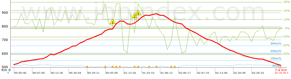
| Total length: 7.34 Km mi / ft ? |
| Analyzed distance: 7.34 Km |
| Lineal distance: 0.02 Km |
| Accumulated climb: 452.78 m |
 info Points list info Points list |
| Accumulated descent: 457.18 m | |
| Maximum height: 893.2 m | |
| Minimal height: 515.4 m | |
| Start height: 520.2 m | |
| End height : 515.4 m | |
| Climb rate: 12.92 % | |
| Descent rate: 12.45 % | |
| Positive climb difference per Km: 61.69 m | |
| Negative descent difference per Km: 62.29 m | |
| Max slope filter: ~30 % |
| Min. points separation: ~30 m |
| Number of points: 665 (cad. 11.04 m) |
| Significant points: 219 (cad. 33.84 m / 32.93 %) |
| Direction changes per Km: 13.08 |
| Direction changes >5ş per Km: 10.08 |
| Accumulated straight stretches: 0.617 Km |
| Straight stretches per Km: 84.06 m |
| Penalizables slope changes: 1 |
| Penalizables slope changes per Km: 0.136 |
| Total time: 2:35:50 h |
| Time in movement: 1:47:52 h |
| Stopped time: 0:47:58 h |
| Total speed average: 2.83 Km/h |
| Average speed in movement : 4.08 Km/h |
| Maximum held speed: 7.35 Km/h |
Your fitness level
?*
|
 |
|
|
Remove track and analysis |
|
|
Save this trail on "My trails" |