Trail difficulty
4706
RNG
|
| Track : x727_7jpko.gpx |
|
These speeds are average for : RNG
(Running) Reanalyze as BYC (Bicycle) HKG (Hiking) |
|
|
Level of correction applied to the trail:
2
 See original analysis (without corrections) See original analysis (without corrections)
|
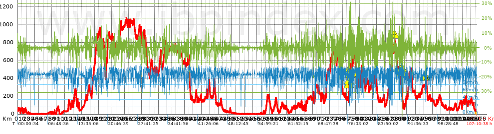
| Total length: 1072.52 Km mi / ft ? |
| Analyzed distance: 1072.52 Km |
| Lineal distance: 0.02 Km |
| Accumulated climb: 20104.46 m |
info Points list |
| Accumulated descent: 20144.07 m | |
| Maximum height: 1073 m | |
| Minimal height: 0.11 m | |
| Start height: 32.9 m | |
| End height : 33.4 m | |
| Climb rate: 4.88 % | |
| Descent rate: 5.12 % | |
| Positive climb difference per Km: 18.75 m | |
| Negative descent difference per Km: 18.78 m | |
| Max slope filter: ~55 % |
| Min. points separation: ~30 m |
| Number of points: 23317 (cad. 46 m) |
| Significant points: 16481 (cad. 65.12 m / 70.68 %) |
| Direction changes per Km: 7.67 |
| Direction changes >5ş per Km: 6.78 |
| Accumulated straight stretches: 86.236 Km |
| Straight stretches per Km: 80.41 m |
| Penalizables slope changes: 204 |
| Penalizables slope changes per Km: 0.19 |
| Total time: 107:10:38 h |
| Time in movement: 107:13:25 h |
| Stopped time: -1:57:13 h |
| Total speed average: 10.01 Km/h |
| Average speed in movement : 10 Km/h |
| Maximum held speed: 14.63 Km/h |
 |
|
|
Remove track and analysis |
|
|
Save this trail on "My trails" |