User: Password:   Login   Login with Facebook   Register

Send to a friend
   

Detailed analysis of the trail analyzed as Bicycle (BYC)
Trail difficulty
743
BYC
Track : 727.gpx
These speeds are average for :  Drawn track (DRW)
Reanalyze as
HKG (Hiking) RNG (Running)
 Penalty trail's conditions: 53 %   ( > 50 % = MTB, < 50 % = RDB)
 Reliability of the original trail: DRW   (10062/51/1/16/-/67)
 Level of correction applied to the trail: 1        See original analysis (without corrections)
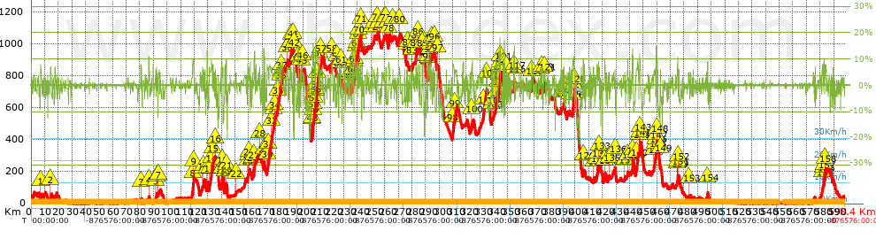
 Total length: 598.12 Km    mi / ft ?
 Analyzed distance: 598.12 Km
 Lineal distance: 0.02 Km
 Accumulated climb: 9336.23 m  info Points list
 Accumulated descent: 9370.49 m
 Maximum height: 1073 m
 Minimal height: 0 m
 Start height: 32.9 m
 End height : 33.4 m
 Climb rate: 4.47 %
 Descent rate: 4.71 %
 Positive climb difference per Km: 15.61 m
 Negative descent difference per Km: 15.67 m
 Max slope filter: ~30 %
 Min. points separation: ~30 m
 Number of points: 12264   (cad. 48.77 m)
 Significant points: 8688   (cad. 68.86 m / 70.84 %)
 Direction changes per Km: 7.07
 Direction changes >5º per Km: 6.18
 Accumulated straight stretches: 54.624 Km
 Straight stretches per Km: 91.33 m
 Penalizables slope changes: 96
 Penalizables slope changes per Km: 0.161
 Total time: 0 h
 Time in movement: 0 h
 Stopped time: 0 h
 Total speed average: 0 Km/h
 Average speed in movement : 0 Km/h
 Maximum held speed: 0 Km/h
Your fitness level
?*
* fit = ? Not enought comparison elements or invalid track


Altitude Slope % Speed Km/h Speed < 2 Km/h

Steep slopes > 10%

Steep slopes >5% Steep slopes >10% Steep slopes >15% Steep slopes >20% Steep slopes >25%
 Steep slope of 290 m.  Average slope  Interval  Download as waypoint
1
 km 86.497  11%  290 m
 Steep slope of 255 m.  Average slope  Interval  Download as waypoint
2
 km 119.543  10%  255 m
 Steep slope of 383 m.  Average slope  Interval  Download as waypoint
3
 km 129.346  13%  383 m
 Steep slope of 236 m.  Average slope  Interval  Download as waypoint
4
 km 143.422  10%  236 m
 Steep slope of 559 m.  Average slope  Interval  Download as waypoint
5
 km 163.882  12%  559 m
 Steep slope of 287 m.  Average slope  Interval  Download as waypoint
6
 km 171.081  14%  287 m
 Steep slope of 318 m.  Average slope  Interval  Download as waypoint
7
 km 196.394  14%  318 m
 Steep slope of 520 m.  Average slope  Interval  Download as waypoint
8
 km 207.342  16%  201 m
9
 km 207.543  11%  319 m
 Steep slope of 961 m.  Average slope  Interval  Download as waypoint
10
 km 209.149  12%  86 m
11
 km 209.235  11%  289 m
12
 km 209.524  12%  586 m
 Steep slope of 390 m.  Average slope  Interval  Download as waypoint
13
 km 237.884  16%  390 m
 Steep slope of 525 m.  Average slope  Interval  Download as waypoint
14
 km 291.769  12%  214 m
15
 km 293.09  12%  311 m
 Steep slope of 982 m.  Average slope  Interval  Download as waypoint
16
 km 343.681  11%  520 m
17
 km 344.57  14%  43 m
18
 km 344.613  18%  231 m
19
 km 344.844  11%  188 m
 Steep slope of 131 m.  Average slope  Interval  Download as waypoint
20
 km 347.983  17%  131 m
 Steep slope of 245 m.  Average slope  Interval  Download as waypoint
21
 km 354.842  13%  245 m
 Steep slope of 273 m.  Average slope  Interval  Download as waypoint
22
 km 398.85  11%  273 m
 Steep slope of 566 m.  Average slope  Interval  Download as waypoint
23
 km 442.019  12%  566 m
 Steep slope of 186 m.  Average slope  Interval  Download as waypoint
24
 km 447.404  12%  186 m
 Steep slope of 267 m.  Average slope  Interval  Download as waypoint
25
 km 459.401  15%  267 m
 Steep slope of 284 m.  Average slope  Interval  Download as waypoint
26
 km 475.274  11%  284 m


Compare this trail with...
Select trails to compare from "My trails". 
demo_montnegrebtt_2013.trk Ref.: 36172170671632
demo_matagalls_montserrat.trk Ref.: 36172170846048
demo_marathon_madrid_2013.trk Ref.: 36172170699197
Compare


Download (Registered users)

  GPX (.gpx)
  Garmin Training Center (.tcx)
  CompeGPS (.trk)
  OziExplorer (.plt)
  Google Earth (.kml)
  PDF analysis


Remove track and analysis
Save this trail on "My trails"


Send this analysis to a friend (Registered users)
Message that will receive your friend:
Re:
Hi.
(your name) has considered that this analysis of a trail could be of your interest.

(he/she will see a link to this page)
E-mail of your friend
You can enter multiple addresses separated by commas
Text
 
Send to a friend